
USGS/Cascades Volcano Observatory, Vancouver, Washington
Long Valley Vicinity, California
Maps and Graphics, etc.
-
 [Map,27K,InlineGIF]
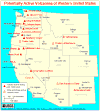
Potentially Active Volcanoes of the Western United States
-- Modified from: Brantley, 1994, Volcanoes of the United States:
USGS General Interest Publication
-
 [Map,20K,InlineGIF]
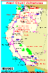
Major West Coast Volcanoes - Washington, Oregon, and California
-
 [Map,21K,GIF]
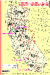
Map of Western United States, showing locations of volcanoes
monitored by CVO
-- Mount Baker to Long Valley
-- Modified from: Iwatsubo and Swanson, 1992,
IN: USGS Bulletin 1966
-
 [Map,65K,InlineGIF]
Areas subject to potential hazards from future eruptions in California.
-- Modified from: Miller, 1989, USGS Bulletin 1847
-
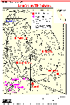
 [Map,18K,InlineGIF]
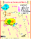
Long Valley Vicinity
-- Modified from: USGS/Menlo Park
-
 [Schematic,13K,InlineGIF]
Vertical Section through Long Valley Caldera
-- Modified from: Newhall and Dzursin, 1988, USGS Bulletin 1855
-
 [Map,36K,GIF]
Long Valley Tilt Network - 1982
-- Modified from: Dzurisin, Cashman, and Sylvester, 1982
-
 [Map,165K,GIF]
Long Valley Rapid Static GPS Network
--
[Map,186K,JPG]
-
 [Map,220K,InlineGIF]
Long Valley Deformation Monitoring Sites - 1999
-- showing permanent GPS sites, EDM sites, and Dilatometers
Return to:
[Long Valley Menu] ...
[California Volcanoes and Volcanics Menu] ...

Use of CVO Material and Copyright Information
URL for CVO HomePage is:
<http://vulcan.wr.usgs.gov/home.html>
URL for this page is:
<http://vulcan.wr.usgs.gov/Volcanoes/LongValley/Graphics/framework.html>
If you have questions or comments please contact:
<GS-CVO-WEB@usgs.gov>
03/23/07, Lyn Topinka
 Link to: Long Valley Observatory Website for MORE Maps and Graphics
 [Map,21K,GIF]
 [Map,36K,GIF]
 [Map,165K,GIF]