
Global GIS Button Page
This page covers buttons and menu items unique to the Global GIS interface. To find out more information on other ArcView buttons or menu items please refer to our Arcview help documents. See Global GIS Quick Start for other detailed information on the Global GIS interface.
Unique Buttons Query Buttons
![]() Create Map Report:
Create Map Report:
Used to generate a feature map from a single lat, lon location. Features searched are within the user's search radius.
![]() Create Text
Report:
Create Text
Report:
Used to generate a feature report from a single lat, lon location. Features searched are within the user's search radius.
![]() Examine One
Feature:
Examine One
Feature:
Used to generate a report on any single feature. Features searched are within the user's search radius.
![]() Select
Feature Totals:
Select
Feature Totals:
Will select and report the total number of features intersected by the user's search radius.
![]() Advance
Search
Advance
Search
Search for information in a theme. This will open up the advanced search tool.
![]() Factbook
Hotlink:
Factbook
Hotlink:
When this button is active, it allows one to click on a country to access information from the World Fact Book.
![]() Population Query:
Population Query:
When this button is active, it allows one to click in the view to access population information.
![]() Drag Search
Radius:
Drag Search
Radius:
Defines the search radius for the Examine Feature routines and the Select Feature Total routine.
![]() Toggle draw
radius on view and map:
Toggle draw
radius on view and map:
Toggles between drawing the examine features tool point location and search radius on the view or not drawing it.
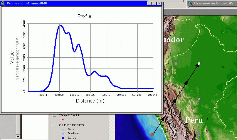
![]() Create Profile Tool:
Create Profile Tool:
The Create Profile Tool allow the user to generate elevation, population, etc. profiles over the raster datasets. Note: To allow ArcView to query the raster datasets we had to generate a generalized 1 x 1 degree point file to hold the raster values. After selecting the profile button, click and drag with the mouse a line and then let go. Here is an example of an elevation profile
![]() Open Earthquake Tools:
Open Earthquake Tools:
The Earthquake Tool opens a new dialog that allows you modify the Earthquake legend, show earth quakes by magnitude ranges, and one year intervals. That interface is shown here.
Unique Graphic Tools Buttons
![]() Erase
All Unlocked Graphics from View:
Erase
All Unlocked Graphics from View:
Erases all unlocked graphics from the current view. Graphics include any text, points, shapes not related to an individual theme.
![]() Locked and Unlock Graphics:
Locked and Unlock Graphics:
These two buttons allows one to lock and unlock graphics to a view. If the graphics (text, points, lines...) are locked the Erase button (above) will not delete them. To lock graphics, select the graphics to lock and click the L (lock) button. If you wish to delete locked graphics, select the graphics and hit the U (unlock) button. Then hit Del on the keyboard or the Erase button.
![]() Turn on
MapTips:
Turn on
MapTips:
Once you have selected the MapTips tool, return to the view window. Activate the themes you wish to query. Click once to start MapTips. Click once to stop. The four color buttons allow you to choose the color of the MapTips text.
![]() Set Text Label
Size Larger or Smaller:
Set Text Label
Size Larger or Smaller:
These two buttons help in setting a text label font size. This will change any text visible on the screen. If you do not wish to resize the political boundary or city labels make sure to turn them off.
![]() Draw
Graticule:
Draw
Graticule:
Draws a graticule or grid on the view. The user must first drag a box to generate the graticule boundaries. This button may also be found when creating a layout.
Unique Table of Contents (TOC) Buttons
![]() Toggle Theme's
Legend:
Toggle Theme's
Legend:
Allows one to toggle a theme's legend in the TOC (table of contents) of the main view.
![]() Open Climate
Options:
Open Climate
Options:
Opens a new interface which allows one to toggle climate themes on and off.
![]() Open Image Options:
Open Image Options:
Opens a new interface which allows one to toggle image layers on and off.
![]() Open Themes
Metadata:
Open Themes
Metadata:
Open themes metadata documentation.
![]() Open Movies, 3D, ...:
Open Movies, 3D, ...:
Opens external animation, image, and perspective files.
Unique Miscellaneous Buttons
![]() Reset
Defaults:
Reset
Defaults:
This resets the Drill Down interface to the startup defaults. The defaults include a 50 kilometer search radius and they will reset all Examine Feature themes to on.
![]() Zoom to Shaded
Relief Base:
Zoom to Shaded
Relief Base:
Zooms to the Shaded Relief base image.
![]() More Viewing Tools:
More Viewing Tools:
Opens up a floating interface which allows you zoom, pan, and refresh previous view.

![]() Delete
Drill Down Theme:
Delete
Drill Down Theme:
This button will delete a feature for the Examine report. Only available in the Advanced Interface, see Global GIS Quick Start
![]() Add Drill Down
Theme:
Add Drill Down
Theme:
This button will add a feature for the Examine report. Only available in the Advanced Interface, see Global GIS Quick Start.
Unique Menu Items
An alternate way to toggle themes on and off. Note: this does not activate or highlight the theme in the table of contents.
Right Mouse Button Tools
By using the right mouse button over the view window, several new options appear:
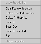
Clear Feature Selection:
Clears any features selected from the active themes
Delete Selected Graphics:
Deletes any selected graphical additions from the view window. This includes added labels, points, text...
Delete All Graphics:
Deletes ALL graphical additions from the view window. This includes added labels, points, text...
[Previous] - ArcView GIS Tool Buttons Project Documents - [Next]