What is ArcView and ArcView DataPublisher?
ArcView GIS
ArcView GIS is a desktop geographic information system (GIS) from Environmental Systems Research Institute, Inc. (ESRI). A GIS is a database that links information to location (it connects the what to the where), allowing you to see and analyze data in new and useful ways.
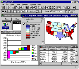
Below is a typical ArcView project. A map, chart, and table have been used to depict migration patterns in the United States.
The ArcView interface consists of windows that present information in different ways. Rows of menus, buttons, and tools at the top of the main application window allow you to view and perform analytical operations on the data in the database.

ArcView DataPublisher
ArcView DataPublisher is a free limited version of ArcView GIS which will work only with the Global GIS datasets. Along with this limitation, the following functions have also been disabled :
- Saving changes to your project
- Opening a new project
- Importing documents from another project
- Creating new event themes
- Address geocoding
- Exporting themes
- Editing themes
- Creating new tables
- Exporting tables
- Editing tables
- DWG and DXF file support
- SQL connections (ODBC support)
- Using DLL extensions
- RPC support
- Using OIScript extensions
ArcView DataPublisher allows the user to add themes and alter theme properties, to view tables, to manipulate the data, and to create charts and layouts. It is possible to print layouts and charts, and it will allow screen snapshots (Windows Print Screen button). It is not possible for the user to save any changes to the project or export any data.
