
|
|

 Update
Summary of the Pu`u `Ō `ō-Kupaianaha Eruption, 1983-present |
|
 |
 |
|
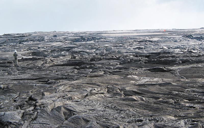
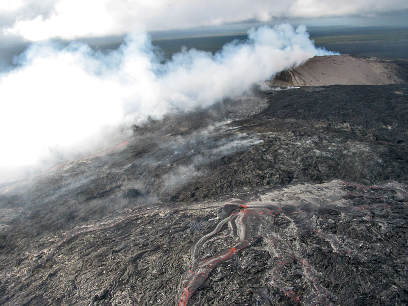
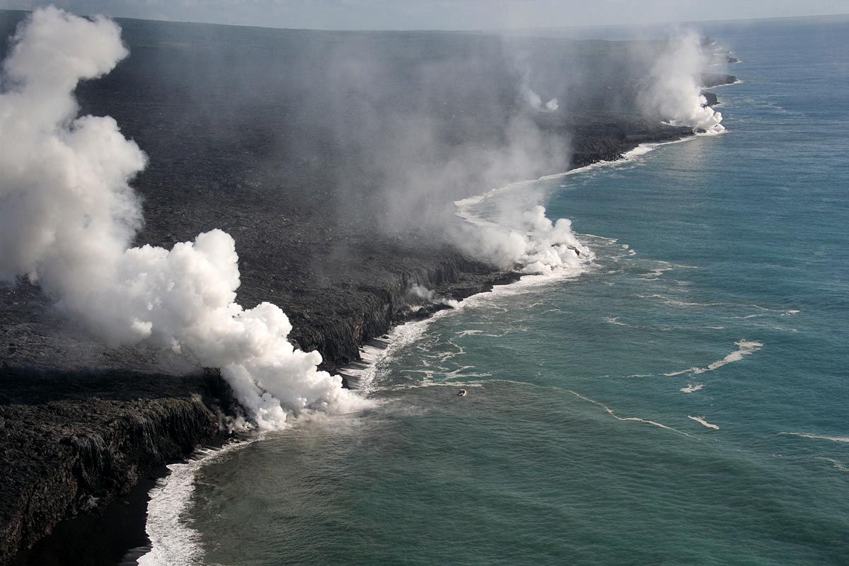
The Pu`u `Ō `ō-Kupaianaha eruption of Kīlauea, now in its twenty-fourth year and 55th eruptive episode, ranks as the most voluminous outpouring of lava on the volcano's east rift zone in the past five centuries. By January 2007, 3.1 cubic km of lava had covered 117 km2 and added 201 hectares to Kīlauea's southern shore. In the process, lava flows destroyed 189 structures and resurfaced 14 km of highway with as much as 35 m of lava. Beginning in 1983, a series of short-lived lava fountains built the massive cinder-and-spatter cone of Pu`u `Ō `ō. In 1986, the eruption migrated 3 km down the east rift zone to build a broad shield, Kupaianaha, which fed lava to the coast for the next 5.5 years. When the eruption shifted back to Pu`u `Ō `ō in 1992, flank-vent eruptions formed a shield banked against the west side of the cone. From 1992 to 2007, nearly continuous effusion from these vents has sent lava flows to the ocean, mainly inside the national park. Flank vent activity undermined the west and south sides of the cone, resulting in the collapse of the west flank in January 1997. Since 1997, the eruption has continued from a series of flank vents on the west and south sides of the Pu`u `Ō `ō cone. During this time the composite flow field has expanded westward, and tube-fed pahoehoe forms a plain that spans 15.6 km at the coast. Resources
Eruption summary
1983-1986, The rise of Pu`u `Ō `ō: episodic lava fountains build massive cone
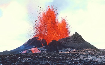
The Pu`u `Ō `ō-Kupaianaha eruption began on January 3, 1983. For the first six months, fissures erupted intermittently along the middle east rift zone from Napau Crater to Kalalua (eruptive episodes 1-3). In June 1983, the activity became localized at the Pu`u `O`o vent, which straddles the boundary of Hawai`i Volcanoes National Park. For the next three years (episodes 4-47), Pu`u `Ō `ō erupted approximately every three to four weeks, usually for less than 24 hours at a time. These eruptive episodes were characterized by spectacular lava fountains that catapulted lava as high as 470 m above the vent. The high fountains produced mainly `a`a flows, the more viscous and crystalline of the two types of Hawaiian lava. `A`a flows from Pu`u `Ō `ō were typically 3-5 m thick and advanced at speeds of 50-500 m/hr, picking up speed and narrowing on steep slopes. Because of the short duration of each eruptive episode, none of these flows reached the ocean or the coastal highway. The flows posed an immediate threat, however, to the sparsely populated Royal Gardens subdivision, located on a steep slope 6 km southeast of the vent. `A`a flows reached the subdivision in as little as 13 hrs during several eruptive episodes. They destroyed 16 houses in 1983 and 1984. Fallout from the towering lava fountains built a cinder-and-spatter cone 255 m high, over twice the height of any other cone on the east rift zone. The cone was strikingly asymmetric, because the prevailing trade winds caused most of the airborne fragments to pile up on the southwest side of the conduit.
1986-1991, Eruption shifts to Kupaianaha: continuous effusion sends lava to the sea
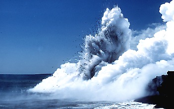
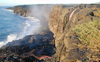
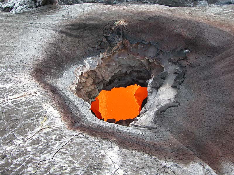
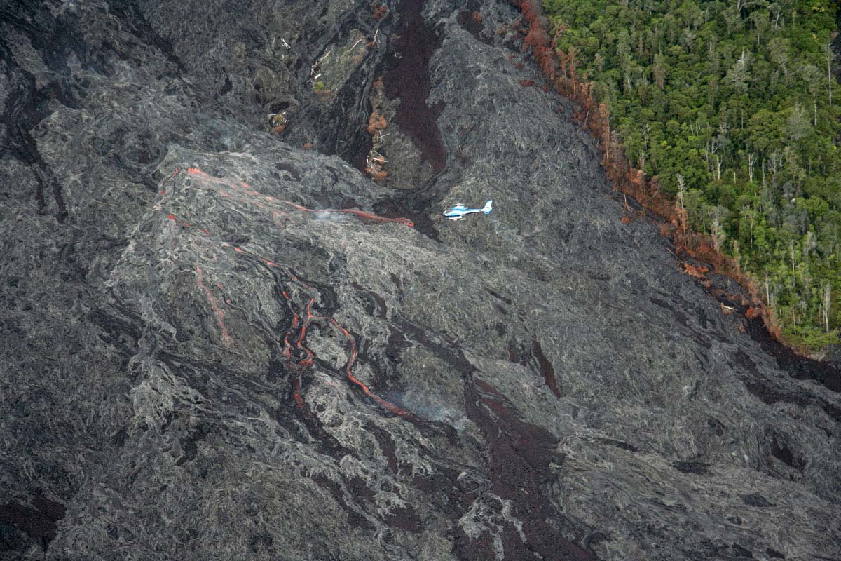
In July 1986, the vertical conduit of Pu`u `Ō `ō ruptured and the eruption shifted to a new vent, Kupaianaha, 3 km northeast of Pu`u `Ō `ō. This marked the end of episodic high fountaining and the beginning of five-and-a-half years of nearly continuous, quiet effusion (episode 48). A lava pond formed over the new vent, and its frequent overflows built a broad, low shield that reached its maximum height of 55 m in less than a year. After weeks of continuous eruption, the main channel exiting from the pond gradually developed a roof as crust at the sides of the channel extended across the lava stream, forming the beginning of a lava tube. Lava tubes insulate rivers of lava from heat loss, producing pahoehoe, a type of lava more fluid than `a`a. The surface of a cooled pahoehoe flow can be flat and smooth, ropy, or undulating. A broad field of tube-fed pahoehoe spread gradually toward the coast, 12 km to the southeast, taking three months to cover the same distance that `a`a flows from Pu`u `Ō `ō traveled in less than a day. By early November 1986, the flows were visible on the steep slope above the small community of Kapa`ahu, and their leisurely pace was no longer reassuring. Late in November 1986, flows from Kupaianaha reached the ocean, cutting a swath through Kapa`ahu and closing the coastal highway. A few weeks later, the lava took a more easterly course and overran 14 homes on the northwest edge of Kalapana in a single day. Luckily for the rest of the village, this flow abruptly stagnated when the tube became blocked near the vent. Over the next three years, lava destroyed homes on either side of the ever-widening flow field. Initially, the course of the pahoehoe flows was strongly influenced by pre-eruption topography, but eventually even the highest ground was inundated. This was not only because pahoehoe re-covered many areas repeatedly, but also because the tube-fed flows thickened from within, inflating as more lava was intruded under the already solid crust of the flow front. From mid-1987 through 1989, most of the lava erupted from Kupaianaha flowed directly to the sea. Steam explosions at the ocean entry fragmented the lava, creating black glassy sand that collected to form new beaches in protected bays down-current from the lava entry. New, albeit unstable, land was added as lava built a series of benches seaward over a steep submarine slope of fragmented lava (see hazards associated with collapsing and exploding lava benches). The long-lived tube system delivering lava to the ocean began to break down in the spring of 1989, and surface flows were a common sight, particularly on the steep slope (Pulama pali) above the coastal plain. Lava flows encroached on new territory, overrunning the Waha`ula Visitor Center and adjoining residences in Hawai`i Volcanoes National Park. The eruption began to change in 1990, when a series of 12 pauses, lasting from 1-4 days, interrupted the steady effusion of lava. At the same time, the eruption entered its most destructive period. In March 1990, the flows turned toward Kalapana, an area cherished for its historic sites and black sand beaches. By the end of the summer, the entire community, including a church, store, and 100 homes, lay buried under 15-25 m of lava (see detailed summary). As the flows advanced eastward, they took to the sea, replacing the palm-lined Kaimu Bay with a plain of lava that extends 300 m beyond the original shoreline. In late 1990, a new lava tube finally diverted lava away from Kalapana and back into the national park, where flows once again entered the ocean. During the five-and-a-half years that Kupaianaha reigned, repeated collapses of the Pu`u `Ō `ō conduit gradually formed a crater approximately 300 m in diameter. A lava pond was present sporadically at the bottom of the crater starting in 1987; since 1990 it has been present much of the time. The volume of lava erupted from Kupaianaha steadily declined through 1991. Concurrently the level and activity of the Pu`u `Ō `ō lava pond rose. In November 1991, fissures opened between Pu`u `Ō `ō and Kupaianaha and erupted lava for three weeks. Kupaianaha continued to erupt during this event (episode 49), but its output was waning. On February 7, 1992, the Kupaianaha vent was dead.
1992-1996, Eruption returns to Pu`u `Ō `ō: flank vents build shield against uprift side of cone
Ten days after Kupaianaha stopped erupting, activity returned to Pu`u `Ō `ō. Lava erupted in low fountains along a fissure on the west flank of the steep-sided cone. This was the first in a series of flank vents that have been active for eight years (episodes 50-53 and episode 55). As at Kupaianaha, the style of the eruption was nearly continuous, quiet effusion. Episodes 50-53 built a lava shield 45 m high and 1 km in diameter that banked against the western flank of Pu`u `Ō `ō. In November 1992, lava crossed the Chain of Craters Road in Hawai`i Volcanoes National Park and entered the ocean at Kamoamoa, 11 km from the vents. Over the next month, tube-fed pahoehoe flows buried the Kamoamoa archaeological site, the National Park's campground and picnic area, and a black sand beach formed earlier in the eruption when flows from Kupaianaha entered the ocean. From the end of 1992 through January 1997, lava tubes fed lava to the ocean almost continuously, broadening the Kamoamoa flow field, which lies mostly within the National Park. Beginning in 1993, collapse pits appeared on the west flank of Pu`u `Ō `ō as lava flowing from the flank vents downcut through tephra beneath the cone. By the end of 1996, the largest of these, known as the "Great Pit", would engulf most of the west flank.
1997-1998, The fall of Pu`u `Ō `ō: collapse claims west flank of cone; episode 55 begins
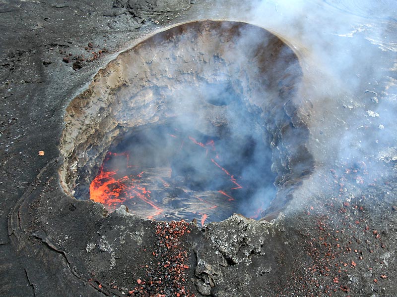
On the night of January 30, 1997, Pu`u `Ō `ō cone changed dramatically. Magma drained from the conduit of Pu`u `Ō `ō, causing first the crater floor, and then the west wall of the cone, to collapse. Shortly thereafter, new fissures broke open and erupted briefly in and near Napau Crater. This event, designated episode 54, was over in 24 hours. The collapse created a large gap in the west side of the cone, and the rubble-lined crater was now 210 m deep. For the next 23 days, no active lava was visible at the eruption site. Episode 55 began on February 24, 1997, when a lava pond returned to the Pu`u `Ō `ō crater. A month later, lava erupted outside the crater from new vents on the west and southwest flanks of the cone. In April 1997, the active lava pond in Pu`u `Ō `ō crater was replaced by a single vent in the western part of the crater, known as the "crater vent." Flows from the crater vent intermittently ponded in the eastern part of the crater. In mid-June 1997, the pond rose until it overtopped the gap in the west wall of Pu`u `Ō `ō, and lava spilled from the crater for the first time in 11 years. Subsequent crater overflows sent lava over the east crater rim to form flows that spread as far as 1.5 km downrift. The spillovers were brief events, ending when the pond drained through conduits in the crater floor. Tube-fed flows from the episode 55 flank vents reached the ocean in July 1997 near the eastern boundary of Hawaii Volcanoes National Park. Lava poured into the ocean at two adjacent sites, Waha`ula and Kamokuna, through 1998. Episode 55 flows have subsequently buried much of the episode-50-53 flow field. The most spectacular event in 1998 was a surge in the supply of magma to Pu`u `Ō `ō on January 14. Lava briefly overflowed the crater (the only time in 1998) and fountains and flows erupted from several collapse pits on the south flank of the cone. For the rest of the year, lava flowed from the south flank vents directly into the tube system. Downcutting beneath the flank vents continued to remove support for the Pu`u `Ō `ō cone. A new collapse pit, Puka Nui, began to form in December 1997 on the southwest flank of the cone. By the end of 1998, Puka Nui was more than 175 m in diameter.
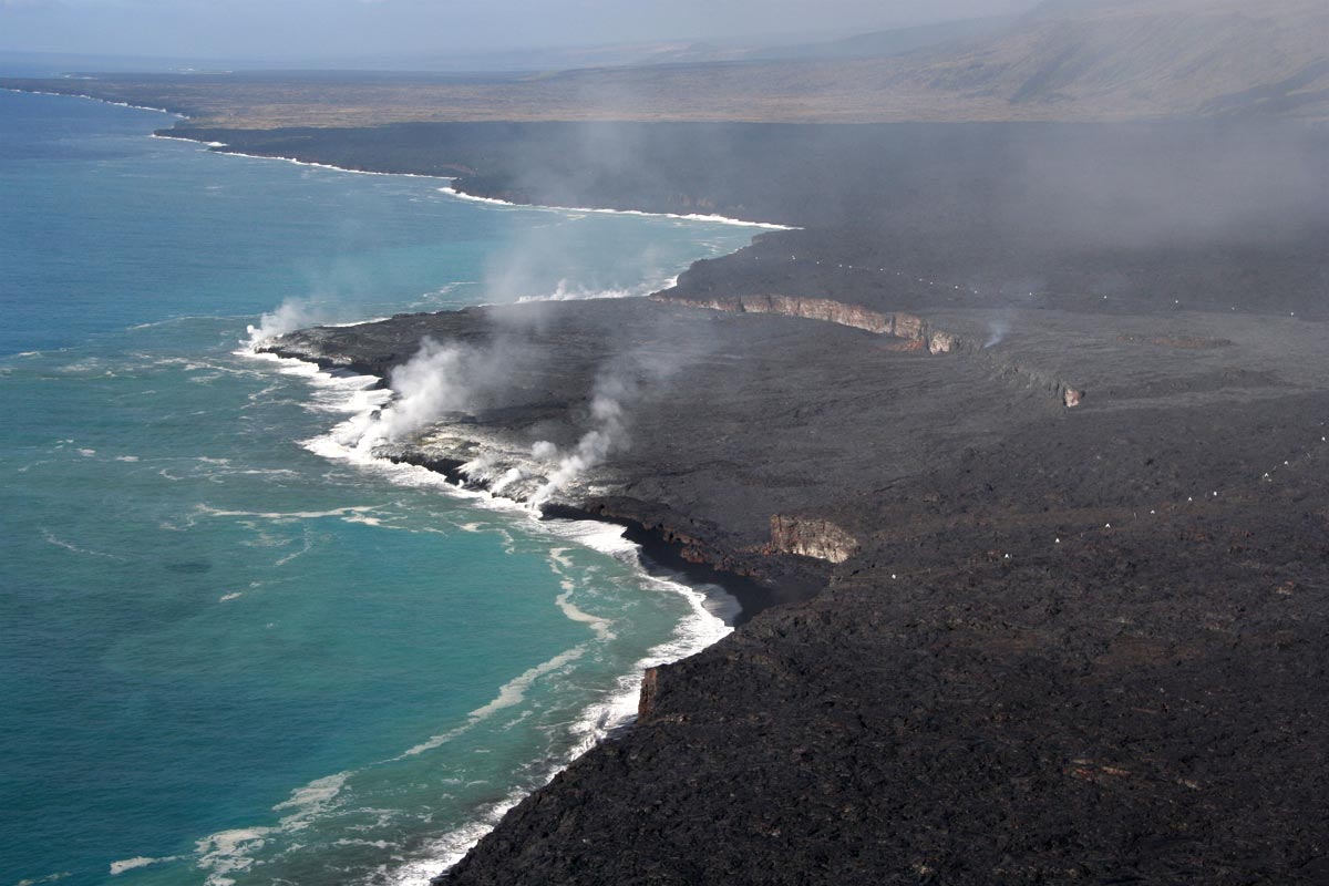
On September 12, 1999, an earthquake swarm and deflation of the summit heralded an intrusion of magma in the upper east rift zone of Kīlauea (see summary in eruption archive, the 7th such event to occur during this eruption. The magma conduit supplying Pu`u `Ō `ō was depressurized as magma was diverted into the upper east rift zone, and the normal supply of magma to the eruption was interrupted for 11 days-the longest pause in activity since the hiatus following the 1997 cone collapse. The eruption resumed with several weeks of heightened activity in and near the crater. Active lava resurfaced most of the crater floor, and about ten new spatter cones formed both inside the crater and on its flanks. New flows floored Puka Nui, the huge composite collapse pit on the southwest flank of Pu'u 'O'o. Prior to the intrusion, the lava tubes had been holding a steady course for 12 months, feeding lava to the coast where it entered the ocean at the Kamokuna site inside Hawai`i Volcanoes National Park. During the pause, however, the long-lived tube system became permanently blocked near the 1750 ft elevation, about 8 km from the coast. When the eruption resumed, surface flows broke out of the tube above this elevation. For several weeks, persistent breakouts at 2050 ft elevation formed large perched ponds over the tube. Hundreds of short flows overflowing from the ponds built a series of rootless shields, 5-20 m high and up to 500 m in diameter, that coalesced to form a prominent ridge along the axis of the tube. Eventually, longer flows advanced down the pali, lava reached the ocean in mid-December at Highcastle and Lae`apuki. These entries were relatively short-lived, and by spring 2000, the active ocean entries had shifted to the eastern side of the flow field. Over the next five months, entries coated the entire seacliff from Kamokuna to the east edge of the flow field. In early 2000, flows crossed the eastern boundary of the national park and encroached on private property. During the next two years, lava overran five abandoned houses in Royal Gardens subdivision, bringing the total number of structures destroyed by this eruption to 189 by the end of May 2002. Ocean entries died out at the beginning of 2001, but picked up again in April, when a new entry was established on the far eastern edge of the flow field at E. Kupapa`u. This was the first ocean entry outside the national park since 1991. In August 2001, the County of Hawaii opened public access to the E. Kupapa`u entry via the east side of the flow field, after improving an existing 4-wheel-drive access road established by Royal Gardens subdivision property owners. Within the first week, 400 vehicles per day traversed the now-historic Kupaianaha flowfield (emplaced from 1987-1991) to see lava enter the sea. A second ocean entry formed at Kamoamoa in late September. Both entries remained active through the end of the year.
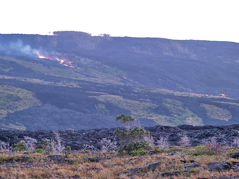
At the end of 2001, the lower reaches of the tube leading to the coast began to stagnate. The ocean entries died in January 2002, and breakouts increased high on the tube, and, as in 1999, overflowing perched ponds built rootless shields along the tube. By the end of March 2002, eight main shields formed a continuous ridge, 2.7 km long and up to 1.5 km wide, between the 2250- and 2000-ft elevations. A fantastic crop of hornitos of all sizes formed over the tube in the first three months of 2002, with with several specimens 8-11.8-m-high. Both the hornitos and the rootless shields require a full tube to form, a condition that was met during January-March 2002 because the lower end of the tube had atrophied. Early 2002 was also a period of heightened activity in and near the Pu`u `Ō `ō crater . Several spatter cones formed within Puka Nui in April-May 2002 and new flows floored the pit. By mid-2002, Puka Nui was 180 by 200 m in diameter, and headward erosion of the upper edge of the pit had carved a notch in the rim of the cone. New spatter cones also formed in the West Gap. In April 2002, a flow advanced from the southeast side of the rootless shields and entered the upper end of Royal Gardens subdivision, where it claimed a long-abandoned house. The "Halp" flow continued its advance through Royal Gardens until mid-June. Meanwhile, on May 12, 2002, a new flank vent opened on the west side of Pu`u `Ō `ō and fed flows down the western margin of the flow field, sparking the largest forest fire in the national park in 15 years . As the "Mothers' Day" flow relieved pressure in the complex magmatic plumbing system beneath Pu`u `Ō `ō, activity in and near the crater died. The older tube, which fed the Halp flow, remained active through August, though its activity was much diminished after the Mothers' Day flow began. The Mothers' Day flow reached the ocean near the end of Chain of Craters Road in July 2002. For the next year, lava entered the ocean nearly continuously at several locations on the western side of the flow field. The longest-lived entry during this period was at West Highcastle. In early 2003, a new breakout from the Mothers' Day tube advanced along the western margin of the flow field. The Kohola flow reached the ocean with a flourish on Valentine's Day, after devouring a fresh section of the Chain of Craters Road and forcing the Park Service to move their mobile visitors' center. The new entry, however, was active for a scant two weeks. Late 2003 was a repeat of early 2002. Activity on the lower reaches of the tube system steadily diminished, and by mid-November 2003, all surface flows from the Mother's Day tube were associated with rootless shield activity within 3 km of the Pu`u `Ō `ō cone. Once again, spatter cones were active in the crater, West Gap, and Puka Nui.
2004-2005, Crater and flank vent activity intensify: PKK flows create multiple ocean entries
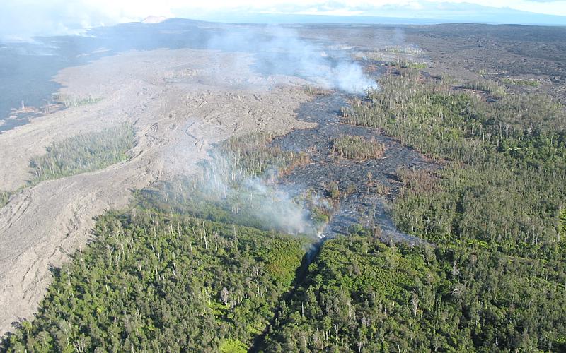
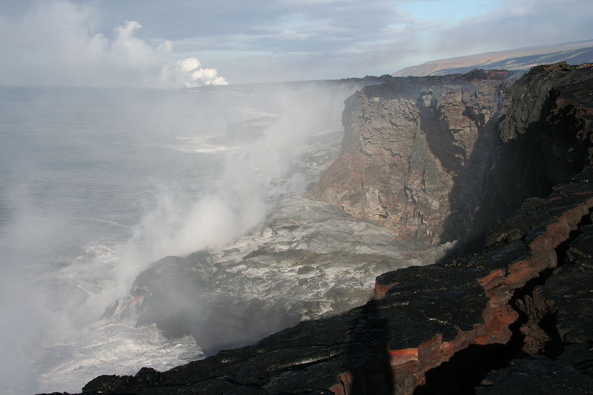
In January 2004, lava flowed out of the crater for the first time since 1998. Small flows briefly overtopped the West Gap and the east rim of the crater on three occasions. A few days later, on Martin Luther King, Jr.'s birthday, four new vents opened on the south side of Pu`u `Ō `ō cone, and produced a short but spectacular flow. For the rest of the year, more vents, collectively known as the MLK vents, opened in the same area. The MLK vents remain active as of June 2005, intermittently producing spatter and short lava flows. Activity in the crater diminished after the MLK vents erupted, but resumed in early February. On February 6-9, lava from vents inside the crater overflowed into Puka Nui for the first time. Lava lows also spilled out of the crater again through the West Gap. After early March, the crater was quiet for the rest of the year. On Prince Kuhio Kalaniana`ole's birthday in March 2004, another major breakout took place southwest of the cone, this time producing substantial lava flows and forming the PKK lava tube. This became the dominant tube by August 2004. Meanwhile, at the beginning of 2004, breakouts from the Mother's Day tube were feeding rootless shield activity on the upper flow field. This remained the case until late April, when the "Banana" flow advanced from the lower margin of the rootless shield field to the coast, reaching the sea at the end of May. This flow remained vigorous through July. The PKK flow was continuously active by August, and the Mothers' Day tube slowly died. Since November 2004, PKK has been the only active lava tube. The PKK flow branched at the top of the pali, forming two widely-separated west and east arms. Lava from the west arm first entered the ocean at East Lae`apuki in November 2004, and from the east arm in January 2005. As of June 2005, the PKK flows had entered the ocean across a wide span of coastline, from Highcastle to Ka`ili`ili. Activity at vents in the Pu`u `Ō `ō crater and on the flanks of Pu`u `Ō `ō pick up from late January through February 2005, with nearly continuous spattering from vents inside the crater. New spatter cones formed inside the crater, at Puka Nui, and at the MLK vents. Activity diminished in March 2005, with spattering usually confined to the most active of the crater vents, the East Pond vent. At the end of March, the spatter cone over the East Pond vent collapsed to reveal a roiling lava pond, which was visible the rest of the year. Only three small flows were erupted onto the crater floor during the rest of 2005: one from the January vent in June and two from the Drainhole vent in October and December (see map for vent locations). In May 2005, one of the MLK cones collapsed, unroofing a lava pond 20 m x 15 m, which crusted over at the end of June. For the rest of 2005, MLK flows were confined to the complex of collapse pits that formed over the vents. The Puka Nui vent had a quiet year after February, when a new 5-6 m high spatter cone formed. This cone collapsed in mid-July. In the last half of 2005, subsidence was the main theme in the crater. In mid-October, over a period of several days, the entire southern part of the crater subsided, claiming several cones on the crater floor and part of the south rim of the crater. In early November, renewed subsidence saw the formation of a shallow trough across the south side of the crater and further slumping of the south crater wall. The PKK flow created six ocean entries during 2005, spanning more than 5 km of coastline. Most of these entries were short-lived; the only one still active at the end of the year was East Lae`apuki. On November 28, 2005, the East Lae`apuki entry produced the largest bench collapse of the eruption. The estimated area of bench that collapsed was 17.8 hectares (44 acres). In addition to the bench, another 4 hectares (10 acres) of pre-2005 lava also calved into the sea. This included much of an episode 55 bench from March 2000, remnants of episode 53 benches from 1996 and 1997, and a portion of the pre-eruption coastline underlying the episode 53 flows.
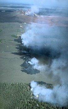
2006 was a quiet year at the eruption site, with subdued activity in the crater and at the flank vents. The PKK tube fed lava continuously to the sea, where the East Lae`apuki ocean entry was active all year. The most significant period of surface-flow activity began in May, when the Campout flow split off from the PKK tube about 1 kilometer south of Pu`u `Ō `ō. In August, the Campout flow reached the ocean at East Ka`ili`ili. A third ocean entry, at Kamokuna, began when an offshoot of the Campout flow reached the ocean in late December 2006. Kamokuna was located about midway between the two older entries. All three entries were active at the year’s end. Lava entered the ocean every day of the year, for the first time during this eruption since 1989. From late 2005 through the first half of 2006, the upper flow field along the PKK lava tube was a breeding ground for shatter rings. Episodic breakouts from the shatter ring area produced only short flows until the Campout flow began in the spring. The Campout flow began to descend Pulama pali on the last day of June and reached the ocean at the beginning of August. Thereafter, breakouts occurred sporadically on the pali and coastal plain along the margins of the new flow. In the last week of September, a narrow finger of the Campout flow stretched eastward into grassland at the base of the pali in Royal Gardens subdivision . After advancing only about 55 m over unburied ground, the finger turned southeast on to older flows and stagnated. On June 24, a large breakout 50 m inland of the sea cliff at East Lae`apuki put on a spectacular show as it cascaded over the 15-m-high sea cliff and quickly resurfaced much of the bench in the next two days. Intermittent flows broke out from this area again in July, and from September through November 2006. A shatter ring formed at the breakout point in mid-September. Inside the crater of Pu`u `Ō `ō , the quiet period that began in late March 2005 continued through 2006. The lava pond at East Pond vent was active throughout the year. The thinly crusted, constantly sloshing pond maintained a relatively constant level about 20–22 m below the rim of the pit. The most conspicuous change was in the rim of the vent, which continued to crumble away, as the pond undermined its walls. The Drainhole vent pond was first observed in mid-March, and waxed and waned through the rest of the year. The pond, which appeared to be at about the same level as that at the East Pond Vent, was heavily crusted, and only about 10 m in diameter. Gas pistoning was observed soon after the pond formed (link to movie page), and became quite conspicuous in June and July. Between November 30 and December 20, the Drainhole pond produced the one-and-only lava flow in the crater in 2006, when it overflowed into the deep subsidence trough beneath the south wall of the crater. The other noteworthy changes in the crater were due to subsidence. In a repeat of October 2005, October 2006 brought renewed (though less extensive) subsidence to the south side of the crater, particularly to the septum between the South Wall Complex and the Drainhole vent. Collapse of the crater floor also triggered subsidence of the slump blocks on the south rim of Pu`u `Ō `ō cone, which dropped several meters. This period of collapse culminated in October with the collapse of the two West Gap cones, leaving a talus floored pit. The last sizeable pit in the West Gap was filled in October 2003, when the two cones that met their demise in 2006 began to form. These cones continued to grow through February 2004; thereafter they only occasionally produced a little spatter. As usual, the flank vent activity matched that of the crater vents. The last overflow from both the MLK and Puka Nui vents was in May 2005. In 2006, small flows on the floor of the MLK pit occurred in January, February, March, April or May, and October. The largest of these was in February, and ponded over much of the pit floor. The Puka Nui vent erupted a few small flows in February and March. These were also contained within a collapse pit. The East Lae`apuki entry was active all year long, and by year’s end, had surpassed several records for this eruption. At the age of 20 months, it was the longest lived entry, and its bench, with an area of 23 hectares, was the largest ever. Since November 28, 2005, East Lae`apuki has also held the record for the largest bench collapse, which claimed 17.8 ha of bench and 4 ha of the adjacent seacliff. By mid-April 2006, the East Lae`apuki bench had exceeded its pre-November 2005 dimensions. The only significant collapse in 2006 occurred on July 30, and removed 3.6 ha from the west side of the bench. The resulting embayment quickly healed, and no more collapses occurred in 2006. The two eastern entries, East Ka`ili`ili and Kamokuna , were fed by the Campout tube. The Campout flow initially produced a long narrow bench at East Ka`ili`ili as the flow spilled over the sea cliff in numerous places along a span of more than 500 m. The bench reached its greatest length by the end of August, when it was 640 m long with an average width of 50 m. Piecemeal collapse prevented the bench from extending farther seaward. In September, the number of entry points was reduced to one, and the inactive eastern end of the bench soon eroded away. In early November, the small bench began to expand seaward and to the west, and by the end of the year had an area of 3 ha. At the beginning of 2007, we remapped the entire 1986-2006 coastline, including the episode-48 coastline, which was last active in 1991. About 30 ha of new land had been lost to wave erosion and mass wasting along the sea cliff. As a result, the net new land created from 1986-2006 decreased. The total area of new land created during this eruption now stands at 201 ha.
ReferencesHeliker, C., and Brantley, S.R., 2004, The ongoing Pu`u `Ō `ō-Kupaianaha eruption of Kilauea Volcano, Hawai`i: U.S. Geological Survey Fact Sheet 2004-3085, 2 p.
| PDF
| HTML |
Heliker, C., Swanson, D.A., and Takahashi, T. J., (eds.), 2003, The Pu`u `Ō `ō-Kupaianaha eruption of Kilauea Volcano, Hawai`i: The first twenty years: USGS Professional Paper 1676. 206 p. Takahashi, T.J., Heliker, C.C., and Diggles, M.F., 2003, Selected images of the Pu`u `Ō `ō-Kupaianaha eruption, 1983-1997: U.S. Geological Survey Digital Data Series DDS-80. Heliker, C., Ulrich, G.E., Margriter, S.C., and Hoffmann, J.P., 2001, Maps showing the development of the Pu`u `Ō `ō--Kupaianaha Flow Field, June 1984-February 1987, Kīlauea Volcano, Hawaii: USGS Geologic Investigations Series, Map I-2685, 4 sheets. C. Christina Heliker, Margaret T. Mangan, Tari N. Mattox, and James P. Kauahikau, 1998, Pu`u `Ō `ō-Kupaianaha eruption of Kīlauea, November 1991-February 1994; field data and flow maps Open-File Report 98-103. Wolfe, E.W. (ed), 1988, The Pu`u `Ō `ō eruption of Kīlauea Volcano:
U.S. Geological Survey Professional Paper 1463, 251 p.
|
||||||||||||||||||||||||


Contact: hvowebmaster@hvo.wr.usgs.gov
Updated: 4 Oct 2008 (pnf)