
|
|

 Summary
Current Update
Eruptive Pause Accompanies Magma Intrusion Into Upper East Rift Zone
The update below is current as of September 14, 1999. This extended update is changed about every 4 to 6 weeks; more frequent updates will be made when there are drastic changes in activity or when residential areas are threatened by lava flows. Update archive.
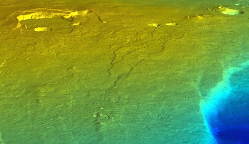 View of Kilauea Volcano looking toward the northeast. | |
| Early on the morning of September 12, a swarm of small earthquakes and volcanic tremor on the east rift zone of Kilauea, and a sharp deflation of the summit area and parts of the east rift zone (see press release), were associated with a new intrusion of magma. Apparently, magma moved from both the summit area and from near Pu`u `O`o into the upper rift zone, forming a dike in the area between Pauahi Crater and Mauna Ulu. Preliminary analysis of the data suggests that 3-5 million m3 intruded into the rift zone. In this illustration, Pu`u `O`o is located beyond Makaopuhi, the large crater in the upper right corner, and the dike is shown reaching from Pauahi (left) to Mauna Ulu (right). |
Overview
Another pause in episode 55 of the Pu`u `O`o - Kupaianaha eruption began at 0131 HST on the morning of September 12. The supply of magma to Pu`u `O`o was interrupted in response to an intrusion into the upper east rift zone in an area between Pauahi Crater and Mauna Ulu, based on the location of small earthquakes and the pattern of ground tilt from several tiltmeters. About 8 hours after the start of the intrusion, the active lava bench on the south coast of Kilauea began collapsing into the sea. Several small collapses were observed by scientists on September 12, and by the evening of September 13, about 2 ha (5 acres) had been removed. The discharge of lava into the sea stopped completely in the afternoon of September 13.
Seismic swarm followed by absence of tremor

Seismogram for seismic station STC, Kilauea Volcano
Part of the September 11-12 seismogram for station STC near Pu`u `O`o. There is a time difference of 15 minutes between each horizontal line and 1 minute between each small tic. Volcanic tremor was normal before the seismic swarm of September 12 but absent afterward, because the eruption entered a pause during the time of the swarm. Click for large image.
Sudden tilt of ground at summit marks intrusion into east rift zone

The intrusion began when three tiltmeters at the summit showed a downward tilt of the ground (red line) toward the caldera. A swarm of small earthquakes along the upper rift zone accompanied the ground deformation. The downward tilt indicates that magma was moving out of the summit reservoir; data from two other tiltmeters on the east rift zone (east of Pauahi Crater and just uprift from Pu`u `O`o) indicate the magma was moving into the rift zone. The reversal of summit tilt about 4-6 hours later indicates when the intrusion stopped and magma once again moved into the summit reservoir. An inspection on September 12 of the ground above the intrusion did not reveal new ground cracks, which suggests the magma intusion did not reach to within 1-2 km of the surface.
Much remains to be learned from this event. Leveling across the zone of intrusion on September 14 showed changes in elevations that provide clear evidence for a dike, but the size and depth of the dike remain to be calculated. The onset of seismicity and tilting on September 12 was abrupt and simultaneous to within the one-minute resolution of the tilt data, all along the rift zone and the summit. This intriguing observation will be the source of considerable interpretative effort by HVO staff and colleagues.
Series of bench collapses begin on September 12
The lava bench began to collapse between 0800-0915 HST and continued for most of the day. The following photos before and after the main collapse events show how much of the bench slid into the sea.
 |
 |

Close view of remaining lava bench on September 13
Photographs by J. Kauahikaua
Flow-field Map
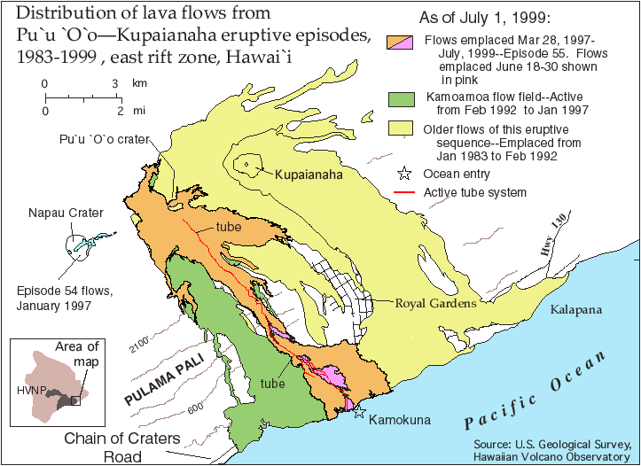
Map showing area covered by lava flows emplaced during the Pu`u `O`o - Kupaianaha eruption between 1983 and July 1, 1999. Flows active between March 28 and July 1, 1999, are shown in pink. The tube delivers lava to the ocean a few hundred meters west of a prominent littoral cone (star) at Kamokuna (click map for a larger view of the map).
Update Archive
Eruption-viewing opportunities change constantly, so those readers planning a visit to the volcano should contact Hawai`i Volcanoes National Park for the most current eruption information (tel. 808-985-6000).
![]()
![]()
![]()
![]()
![]()
![]()
![]()
![]()
![]()
![]()
Contact: hvowebmaster@usgs.gov
Updated: 15 September 1999