 Global Analysis / Global Hazards / United States / U.S.
Drought / Extremes
Global Analysis / Global Hazards / United States / U.S.
Drought / Extremes
Use these links to access detailed analyses of Global and U.S. data.

 Drought & Heat | Flooding | Storms | Tropical Cyclones | Extratropical Cyclones | Severe Winter Weather

| A multi-month period of wet weather across southwestern areas of the United States ameliorated drought conditions in parts of California, Arizona and New Mexico. Extreme to exceptional drought persisted farther north throughout portions of the northern and central Rockies. |

Larger Image
|

Larger Image
|
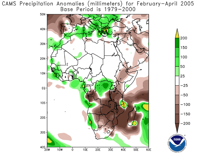
Long-term drought continued across areas of the Greater Horn of Africa (eastern Kenya, southeastern Ethiopia, northern/central Somalia and Djibouti) and southern Africa. In Kenya, two million people were in need of food aid (WFP). Widespread crop failure over much of Mozambique, southern and eastern Zimbabwe, as well as adjacent parts of Malawi and South Africa, was the result of less than half the normal rainfall during the rainy season. For the latest African analysis and forecast, see the Famine Early Warning System Network.
|
| Drought across Thailand is reportedly the worst in seven years. Two million hectares (5.2 million acres) of farmland have been damaged, while causing $191 million (USD) in economic losses. More than 9 million people in 71 of Thailand's 76 provinces have been affected by water shortages. Government-sponsored cloud seeding operations were employed as an attempt to mitigate the drought conditions (Associated Press).
|

Larger Image
|


|
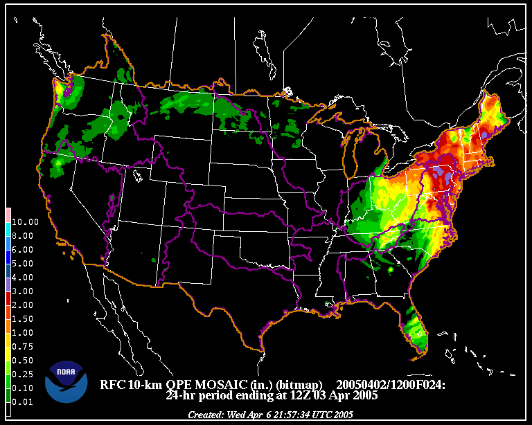
In the United States, heavy rainfall in the Northeast produced flooding in parts of New York, New Jersey and Pennsylvania. Severe flooding along the Delaware River forced the evacuation of 6,000 residents in New Jersey and over 5,700 in Pennsylvania during the weekend of the 2nd-3rd. Around 3,200 homes in New Jersey were damaged, while one fatality was reported in New York (Associated Press). |

Larger Image
|
Across Zanzibar Island off the coast of Tanzania, heavy rains associated with showers and thunderstorms during April 17-19 produced heavy flooding described as the worst in 40 years. At least 150 familes lost their homes due to the flooding (IFRC).
In Romania, flooding in the northern and western parts of the country damaged thousands of homes and submerged 30,000 hectares (75,000 acres) of farmland. More than 140 towns were affected by the flooding, which prompted government officials to issue a regional state of emergency (AFP).
Heavy rain in the Somali region of Ethiopia during April 21-30 produced flooding that caused 134 fatalities and displaced nearly 250,000 (AFP/OCHA).
In the Indonesian province of Aceh, flooding rains were responsible for 15 deaths and the destruction of 490 homes in the village of Lawe Mengkudu on the 26th. (AFP).
|

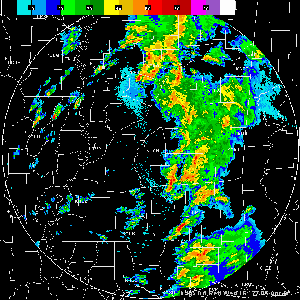
Click For Radar Animation
|
Thunderstorms erupted on April 6 and produced severe weather including 32 reports of tornadoes, most of which touched down in Mississippi and Louisiana. Between 20 and 25 homes were destroyed and 7 people were injured. Mississippi governor Haley Barbour declared a state of emergency (CNN).
|
|
Severe thunderstorms affected the eastern China province of Jiangsu on the 20th, producing a deadly tornado near the city of Yancheng. There were seven people killed and at least 60 injured (AFP/Associated Press). |

Larger Image
|


Larger Image
|
Typhoon Sonca developed in the western Pacific Ocean on the 20th, and passed near the Yap Islands as a depression on the 21st. Sonca attained typhoon status by the 23rd, but remained offshore before recurving to the northeast and weakening over cooler waters. |

|
No reports of significant extratropical cyclones were received during April 2005.
|

|
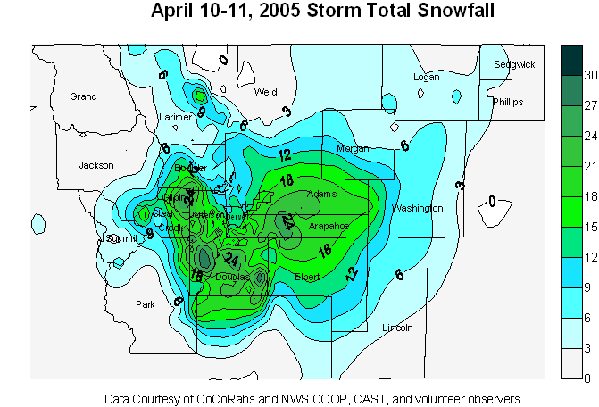
Heavy snow affected the Colorado Rockies during April 10-11, 2005, as up to 76 cm (30 inches) of snow affected the mountains around Denver. In the Denver metro area, 25-38 cm (10-15 inches) of snow accumulated. |

Larger Image
|
|
Elsewhere in the United States, snow fell across portions of the Great Lakes southeastward into the central and southern Appalachians on April 24. In the greater Cleveland, OH area, locally one foot (30 cm) of snow accumulated.
|
References:
Basist, A., N.C. Grody, T.C. Peterson and C.N. Williams, 1998: Using the Special Sensor Microwave/Imager to Monitor Land Surface Temperatures, Wetness, and Snow Cover. Journal of Applied Meteorology, 37, 888-911.
Peterson, Thomas C. and Russell S. Vose, 1997: An overview of the Global Historical Climatology Network temperature data base. Bulletin of the American Meteorological Society, 78, 2837-2849.
For all climate questions other than questions concerning this report, please contact the National Climatic Data Center's Climate Services Division:
- Climate Services Division
NOAA/National Climatic Data Center
151 Patton Avenue, Room 120
Asheville, NC 28801-5001
fax: 828-271-4876
phone: 828-271-4800
email: ncdc.orders@noaa.gov
For more information, refer also to ...
March Hazards and Significant Events
Selected U.S. City and State Extremes
2004 Atlantic Hurricanes
2004 East Pacific Hurricanes
2004 U.S. Wildfire Summary
SSMI Derived Products
Global Historical Climatology Network (GHCN)
The Blended GHCN - SSM/I Product
The Global Temperature Anomalies
CLIMVIS - Global Summary of the Day
CAMS data provided by the Climate Prediction Center
Tropical Rainfall Measuring Mission (TRMM) - NASA
Geographic Reference Maps (pdf format)
|
For further information on the historical climate perspective presented in this report, contact:
- Scott Stephens
NOAA/National Climatic Data Center
151 Patton Avenue
Asheville, NC 28801-5001
fax: 828-271-4328
email: Scott.Stephens@noaa.gov
|
 NCDC / Climate
Monitoring / Climate
of 2005 / Hazards / Help NCDC / Climate
Monitoring / Climate
of 2005 / Hazards / Help
|


