 Global Analysis / Global Hazards / United States / U.S.
Drought / Extremes
Global Analysis / Global Hazards / United States / U.S.
Drought / Extremes
Use these links to access detailed analyses of Global and U.S. data.

 Drought & Heat | Flooding | Storms | Tropical Cyclones | Extratropical Cyclones | Severe Winter Weather

| A multi-month period of wet weather across southwestern areas of the United States ameliorated drought conditions in parts of California, Arizona and New Mexico. Extreme to exceptional drought persisted farther north throughout portions of the northern and central Rockies. |

Larger Image
|

Larger Image
|
Long-term drought continued across areas of the Greater Horn of Africa and southern Africa. Low water levels on Lake Victoria reduced flows into the Nile and diminished hydroelectric power generation in Uganda. Farther north across Eritrea, long-term drought promoted worsening food shortages throughout the country, with malnutrition estimated above 10 percent (OCHA). For the latest African analysis and forecast, see the Famine Early Warning System Network.
|
|
Severe drought conditions affected southern Brazil during March. The southernmost state of Rio Grande do Sul, which typically is one of Brazil's most prolific agricultural states, was the worst-affected. With little to no rainfall since December 2004, 440 cities and towns declared a state of emergency due to water shortages, where major economic impacts were reported (Associated Press/CNN). |

Larger Image
|


|
In Algeria, heavy rainfall on the 6th-7th caused flooding in the Saharan desert region resulting in 2 deaths and 9 injuries (AFP). |

Larger Image
|

Larger Image
|
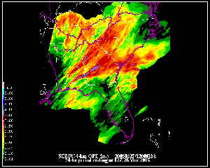
Heavy rain caused flooding in parts of Pakistan and Afghanistan during March. Flooding which began in February in Pakistan continued into March, affecting the particularly hard-hit Balochistan province. There were more than 30 fatalities during the month in southwestern Pakistan. In neighboring Afghanistan, at least 24 deaths were blamed on flooding from rainfall and snowmelt (Associated Press/AFP).
|
|
Across Angola, above-normal wet season rainfall generated flooding in the northern Kwanza Norte province. The flooding was responsible for rendering at least 10,000 people homeless in the province (OCHA). |
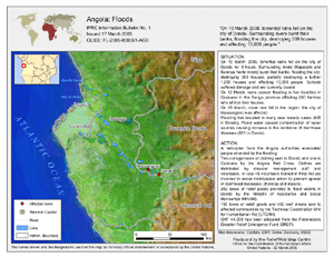
Larger Image
|
Flooding in Madagascar during the first week of March claimed 25 lives, displaced more than 8,000 from their homes, and flooded 35,500 hectares (88,000 acres) of agricultural land (OCHA).
For an archive of flood events worldwide, see the Dartmouth Flood Observatory.
|
Larger Image
|
Showers and thunderstorms affected the southeastern United States during March 27-28 with rainfall totals of 50-100 mm (~2-4) inches common in parts of Georgia, South Carolina, Mississippi and Alabama. Flooding forced some people from their homes, washing out roads and flooding rivers (Associated Press). |

In New Zealand, a tornado tore through the town of Greymouth on the West Coast on the 9th. While no injuries were reported, the tornado cut a 300-meter (~1,000 feet) wide path of destruction through the town (AFP).
|
| A severe thunderstorm brought significant hail and a tornado to northern Bangladesh on March 20. The storm destroyed 3,000 houses and killed at least 56 people in the districts of Gaibandha and Rangpur, where severe damage was reported in 20 villages (AFP/BBC/OCHA).
|

Larger Image
|

| Tropical Cyclone Ingrid developed in the Coral Sea on the 6th and reached Australia's northern coast of Queensland on the 10th. The storm made landfall near the town of Lockhart River with maximum sustained winds near 185 km/hr (115 mph). This was reportedly the strongest tropical cyclone to strike the coastline of Queensland in more than three decades (CNN/BBC). |

Tropical Cyclone Ingrid
|

Larger Image
|
Ingrid continued westward into the open waters of the Gulf of Carpentaria, skirting the northern coast of the Northern Territory during the 11th-13th, with peak sustained winds during this time period near 250 km/hr (135 knots or 155 mph). Ingrid passed north of Darwin and lashed relatively isolated areas of the Arnhem Land region. Croker Island, located in the Arafura Sea, sustained damage to trees, powerlines and roofs on buildings, although no injuries were reported (AFP/Reuters). The cyclone entered the Timor Sea before making a third and final landfall in the remote northern tip of Western Australia near Kalumburu on the 15th. Maximum sustained winds near the time of landfall were around 240 km/hr (130 knots or 150 mph). |
| Typhoon Roke developed across the Caroline Islands on the 13th, reaching typhoon intensity by the 15th as it tracked westward. The typhoon reached the central Philippines by the 16th with maximum sustained winds near 120 km/hr (65 knots or 75 mph). Roke weakened below typhoon strength as it tracked over land, re-emerging in the open waters of the South China Sea by the 17th before dissipating. |

Typhoon Roke
|
Larger Image
|
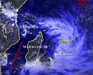
Tropical Cyclone Hennie developed in the South Indian Ocean on the 21st and passed just east of Mauritius on the 24th. Maximum sustained winds reached 120 km/hr (65 knots or 75 mph), although these stronger winds remained off the coast of Mauritius. |

Larger Image
|
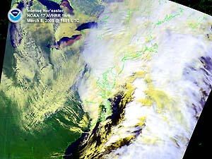
A powerful storm system brought a variety of weather impacts to the eastern United States on March 8. Strong thunderstorms affected the eastern Carolinas, while strong winds, heavy rain and heavy snow affected areas of the Mid-Atlantic and Northeast. Minimum central pressure with the storm dropped to near 960 mb (28.35 inches of mercury) just off the coast of Maine and New Brunswick. Wind gusts over 95 km/hr (60 mph) were reported, along with heavy accumulations of snow in some areas. |

| Above average snow cover characterized much of Europe and Asia during the early part of March, as unusually cold and snowy conditions throughout the boreal winter season persisted through the 9th. Across Serbia and Montenegro, snow depths exceeding 2 meters (6.5 feet) were reported in some areas, cutting off some residents (IFRC). |

Animation
|
References:
Basist, A., N.C. Grody, T.C. Peterson and C.N. Williams, 1998: Using the Special Sensor Microwave/Imager to Monitor Land Surface Temperatures, Wetness, and Snow Cover. Journal of Applied Meteorology, 37, 888-911.
Peterson, Thomas C. and Russell S. Vose, 1997: An overview of the Global Historical Climatology Network temperature data base. Bulletin of the American Meteorological Society, 78, 2837-2849.
For all climate questions other than questions concerning this report, please contact the National Climatic Data Center's Climate Services Division:
- Climate Services Division
NOAA/National Climatic Data Center
151 Patton Avenue, Room 120
Asheville, NC 28801-5001
fax: 828-271-4876
phone: 828-271-4800
email: ncdc.orders@noaa.gov
For more information, refer also to ...
Selected U.S. City and State Extremes
2004 Atlantic Hurricanes
2004 East Pacific Hurricanes
2004 U.S. Wildfire Summary
SSMI Derived Products
Global Historical Climatology Network (GHCN)
The Blended GHCN - SSM/I Product
The Global Temperature Anomalies
CLIMVIS - Global Summary of the Day
CAMS data provided by the Climate Prediction Center
Tropical Rainfall Measuring Mission (TRMM) - NASA
Geographic Reference Maps (pdf format)
|
For further information on the historical climate perspective presented in this report, contact:
- Scott Stephens
NOAA/National Climatic Data Center
151 Patton Avenue
Asheville, NC 28801-5001
fax: 828-271-4328
email: Scott.Stephens@noaa.gov
|
 NCDC / Climate
Monitoring / Climate
of 2005 / Hazards / Help NCDC / Climate
Monitoring / Climate
of 2005 / Hazards / Help
|


