 |
 |
||
 |
| Site Map | News | Organization |
|
You have arrived at the NWFO Jackson Mississippi Storm of the Month webpage. Here you can view RADAR images of intense storms that occurred within the KJAN(Jackson MS)or KDGX(Brandon MS) WSR-88D Coverage Umbrellas of approximately 124nm and that were selected by the staff as being most impressive for that particular month. The KJAN radar served the area from 4/1993 to 2/2003 and the KDGX 88D radar began coverage for the area on 2/19/2003. The new radar location facilitates improved radar detection ability for much of the eastern third of Mississippi...especially in regard to rainfall amounts.
| ||||||||||||||||||||||||||||||
| YEAR/MO | JAN | FEB | MAR | APR | MAY | JUN | JUL | AUG | SEP | OCT | NOV | DEC | YR! |
| 1995 | '95 | ||||||||||||
| 1996 | '96 | ||||||||||||
| 1997 | '97 | ||||||||||||
| 1998 | '98 | ||||||||||||
| 1999 | '99 | ||||||||||||
| 2000 | '00 | ||||||||||||
| 2001 | '01 | ||||||||||||
| 2002 | '02 | ||||||||||||
| 2003 | note: | JAN | data | ends | .... | DGX | begins | 03/ | '03 | ||||
| 2003 | ^^^^ | ^^^^ | '03 | ||||||||||
| 2004 | OCT | NOV | DEC | '04 |

| 
| 
|  |
 |
 |
 |
![]()
![]()
![]()
![]()
![]()
![]()
![]()
![]()
![]()
![]()
![]()
![]()
![]()
![]()
![]()
![]()
![]()
![]()
![]()
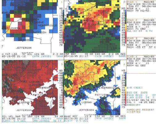
| Link to
a Composite Reflectivity Loop of the May 1995 Storm(image ~1mb) |
 Work In Progress |
| Local Climate Water & Weather Topics: Current Hazards, Current Conditions, Radar, Satellite, Climate, Weather Safety, Contact Us |
| National Weather Service 234 Weather Service Drive Jackson, MS 39232 (601) 936-2189 Contact us Page last modified: June 1, 2005 |
Disclaimer | Privacy Notice |
 k!
k!