Tanya caused gale force winds over the Azores, while losing
its tropical characteristics.
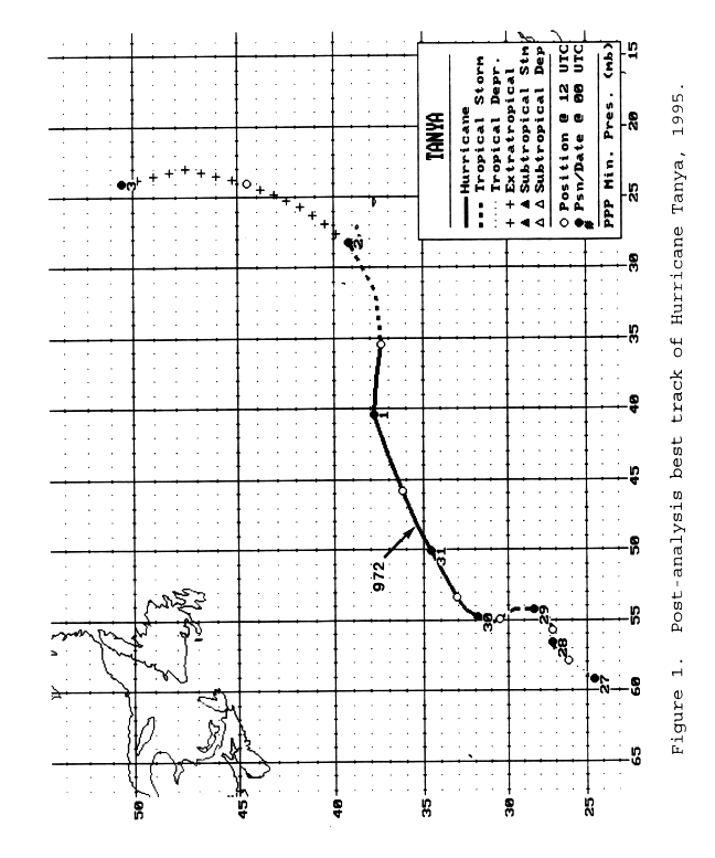
a. Synoptic History
Tanya originated from a tropical wave that,
based on extrapolation, moved off the west coast of Africa in mid-October.
This wave followed one that spawned Tropical Storm Sebastien, and
was not easily identifiable as a cloud mass on satellite pictures
until 20 October, when it neared 40°W longitude in the tropical
Atlantic. The wave moved slowly westward for a few days. By 24
October, cloudiness associated with the wave merged with an area of
convection to the east and northeast of Tropical Depression
Sebastien. This weather was partly associated with an upper-level
cyclone that was
producing shearing winds over Sebastien,
causing its demise. At 1800 UTC on the 25th, a low cloud swirl was evident
in the vicinity of 22°N 60°W. However, this system was barely classifiable by the
Dvorak technique
since deep convection was not very close to the
center. The low-cloud swirl
became more pronounced on satellite images on the 26th. By 0000 UTC 27
October, surface observations indicated a definite closed surface
circulation, and the tropical depression
stage of Tanya is initiated at this time in the post-analysis
best track (Table 1
and Fig. 1 [63K GIF]).
The movement of the tropical cyclone
was controlled mainly by two factors: shortwaves in the midlatitude westerlies and the
upper-level cyclone in Tanya's vicinity. Initially the cyclone
moved northeastward, in response to an approaching shortwave
trough. However, due to the effect of the upper cyclone, Tanya
turned more eastward and slowed.
Because of the influence of the upper-level cyclone, the
development of Tanya was not like that of a typical tropical
cyclone in the deep tropics. On the 27th and 28th, the system had some
subtropical characteristics, i.e. a large
comma-shaped cloud band and strongest winds well removed from the center. Nonetheless,
Tanya's winds increased to tropical storm
force by 1200 UTC on the 27th and gradual strengthening continued
thereafter. Convection developed closer to the center by 1800 UTC
on the 28th, and on the following day the cloud pattern was more
symmetrical about the center. Tanya reached
hurricane
strength around 1200 UTC on the 29th, when a small
eye was observed in the
middle of the central dense overcast.
While Tanya was strengthening into a hurricane, its motion was
cyclonic along roughly a half-circular path, again due to the
adjacent upper low. This movement continued into the 29th, when a
strong eastward-moving mid-tropospheric trough over the western
Atlantic, and associated cold front near Bermuda, began to
influence the track of the hurricane. Tanya turned north-
northeastward on the 30th, and east-northeastward later that same
day. Early on the 31st, while still embedded in a narrow wedge of
warmer air between cooler air masses over the western and eastern
Atlantic, the system acquired peak intensity of 75-knot
winds with a 972 mb central pressure.
On the 1st of November, Tanya veered to the east and weakened
to a tropical storm - headed in the general direction of the
Azores. As the storm neared those islands, the movement became
more northeasterly, taking the center just to the north of the Azores. Tanya was becoming
extratropical as it passed near the
Azores. The extratropical cyclone turned north-northeastward, then
northward, and was absorbed into a larger low pressure system over
the north Atlantic by 0600 3 November.
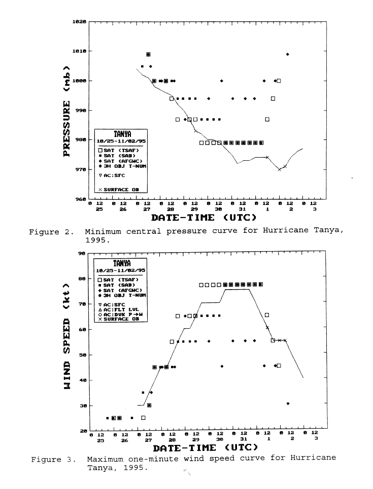
b. Meteorological Statistics
The post-analysis best track intensities are listed in Table 1
and displayed in Figs. 2 and 3 (56K GIF),
which show the estimated minimum central pressure and maximum one-minute wind speed,
respectively, versus time. These intensity estimates were derived mainly from
analyses of satellite images, using the Dvorak technique, performed by meteorologists at the
Synoptic Analysis Branch (SAB), the
Tropical Analysis and Forecast Branch
(TAFB; formerly the Tropical Satellite Analysis and Forecast unit, TSAF, as in the figures), and
at the Air Force Global Weather Central (AFGWC).
There were some surface observations from the Azores of sustained
gale force winds. Lajes Air Base on Terceira measured sustained
winds of 34 knots at 2255 UTC with gusts to
59 knots at 2343 UTC on
the 1st. Santa Maria Island reported sustained winds of 39 knots
at 2300 UTC on the 1st, with gusts to 50 knots at 0200 UTC on the
2nd. Lowest pressure observed in the Azores was 973.5 mb at Horta
on the island of Faial.
Table 2 is a listing of ship reports of tropical
storm force wind speeds associated with Tanya. One ship, with call sign GBSA,
had the misfortune of being near the center of Tanya twice: on the
29th, when Tanya was a hurricane; and on the 2nd, when Tanya was an extratropical storm.
c. Casualty and Damage Statistics
Although strong winds likely had some impact on the Azores and
ships that were affected by Tanya, no reports of casualties or
damage have been received at the NHC.
d. Forecast and Warning Critique
At 12, 24, 36, 48, and 72 hours, the mean official forecast
errors for Tanya were 65, 121, 166, 237, and 357 n mi,
respectively. These are 20 to 30 per cent larger than the most
recent ten-year average errors. This is not too surprising, since
Tanya was a relatively high-latitude tropical cyclone, and track
forecasts for such systems are typically not as good as those for
cyclones in the deep tropics. The average official forecast error
was comparable to, or lower than, the average error of any of the
available objective track prediction models.
Beginning at 0300 UTC 1 November, a statement was included in
the advisories that tropical storm conditions were expected to
spread over the Azores within 24 hours. This turned out to be
roughly correct, since sustained winds of at least 34 knots
occurred at these islands around 0000 UTC on the 2nd. However,
Tanya is estimated to have lost tropical characteristics by that time.
![[NCEP Logo]](graphics/ncep.gif)