a. Synoptic History
Pablo was a Cape Verde-type tropical storm
that did not affect land.
Pablo originated from a tropical wave
which moved from Africa to the Atlantic Ocean on October 3rd. The wave acquired a low-
level circulation and became a tropical depression
at 1800 UTC on the 4th, while it moved westward at 15 to 20 knots and was centered
about 600 n mi southwest of the Cape Verde Islands. The official track
of Pablo, listed in Table 1 and plotted in
Fig. 1 (41K GIF), begins at this time.
Pablo became a tropical storm on the 5th. Its movement was
rather fast toward the west-northwest and then west across the
tropical Atlantic for the next three days under the influence of
deep easterlies. It is estimated that the storm's sustained winds
reached their maximum value of 50 knots on the 6th and then stayed
near 45 knots until the 8th, when the storm encountered very strong
vertical shear and quickly dissipated while centered about 135 n mi
east-southeast of Barbados.
b. Meteorological Statistics
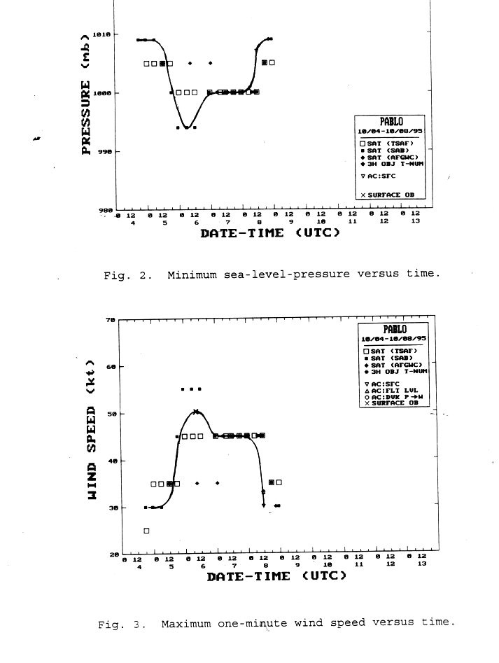
Only one reconnaissance mission investigated Pablo on the
morning of the 8th, and was unable to locate a well-defined low-
level wind center.
The minimum sea-level pressure and flight-level
wind speed observations from this aircraft are plotted in
Figs. 2 and 3 (45K GIF), respectively.
Wind speed estimates from satellite data
are plotted in Fig. 3
and the corresponding pressure from the Dvorak pressure-wind relation is
plotted in Fig. 2.
One ship reported tropical-storm-force winds from Pablo and its
observations are listed in Table 2.
c. Casualty and Damage Statistics
There are no deaths or damages attributed to Pablo.
d. Forecast and Warning Critique
The official track forecast errors for Pablo averaged 127 n mi
at 24 hours based on nine cases, 198 n mi at 48 hours from five
cases, and 314 n mi at 72 hours from only one case. These errors
are slightly above the previous ten-year averages. In the early
stages, Pablo was over-forecast to become a 65-knot hurricane and
this resulted in a positive bias to the official wind speed forecast errors.
A tropical storm watch
was issued for Martinique, Dominica and Guadeloupe at 2100 UTC on the
7th, when Pablo was centered about 370 n mi east of Barbados.
This watch was extended to include St.
Maarten, Saba and St. Eustatius six hours later, and to include
Barbados, St. Vincent and the Grenadines at 0900 UTC on the 8th.
The watch was extended again at 1500 UTC to include Grenada and
was, at the same time, discontinued for St. Maarten, Saba and St.
Eustatius. Finally, all watches for the Lesser Antilles were
discontinued at 1800 UTC on the 8th, as Pablo was dissipating.
![[NCEP Logo]](graphics/ncep.gif)