|
 Global Analysis / Global Hazards / United States / U.S.
Drought / Extremes
Global Analysis / Global Hazards / United States / U.S.
Drought / Extremes
Use these links to
access detailed analyses of Global and U.S. data.

 Drought & Heat | Flooding | Storms | Tropical Cyclones | Extratropical Cyclones | Severe Winter Weather

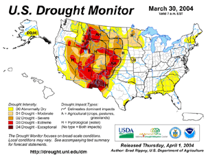
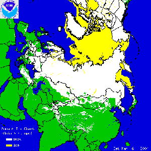
| Significant precipitation during the winter season alleviated drought conditions along the immediate West Coast, although severe to extreme drought classification continued in March throughout the Intermountain West, the Northern Rockies, and southward into New Mexico. |
larger image
|
For complete drought analysis throughout the United States, please see the U.S. regional drought pages.
larger image
|
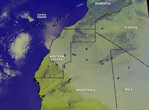
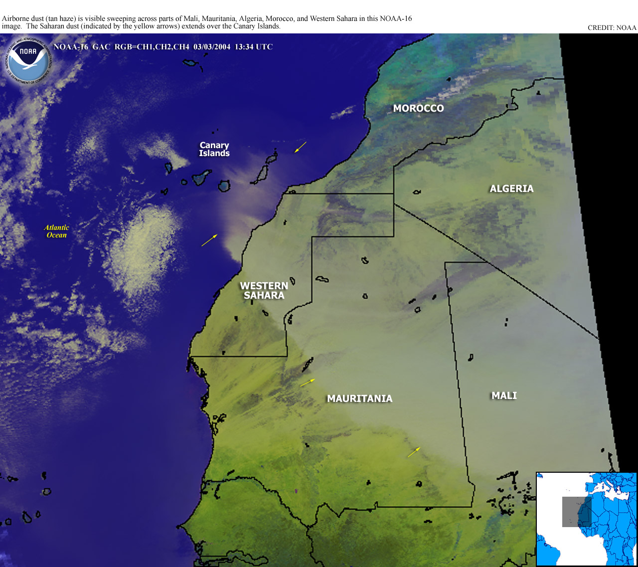
A dust storm originating from the Sahara Desert affected much of Mali, Mauritania, Algeria, Morocco and Western Sahara during early March. In Mali, air traffic was disrupted during the 4th-5th at the Bamako-Senou international airport. In Bamako, visibilities on March 4 were as low as a few hundred meters (yards) (AFP).
|
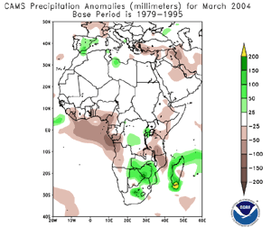
| Long term drought continued across areas of Africa, including the Greater Horn and parts of southern Africa (WFP). In Eritrea, it was estimated than more than half of the population (1.9 million) would require food aid during 2004 (USAID FEWS). |
 larger image larger image
|
Drought affected areas of Vietnam during March 2004. In the northern Son La province some 1,000 families were without clean water for daily use. In the central highlands province of Gia Lai, 1,600 hectares (4,000 acres) of rice and maize were endangered (Xinhua).


larger image
|
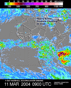
In northwestern Iran, at least one person was killed as flash floods triggered by torrential rains swept across parts of the West Azerbaijan province late on the 7th. The rains produced flooding along the Simineh River.
|
Heavy rains in Papua New Guinea produced flooding that swept away bridges, washed away roads and destroyed hundreds of homes during the latter half of March 2004. Flooding earlier in the month prompted the evacuation of more than 10,000 people in the Western Highlands after heavy rain brought the Waghi River above the flood stage (AFP).
In the upper Midwest of the United States, heavy rain produced flooding in areas of northeastern North Dakota, as well as in parts of Wisconsin. North Dakota governor John Hoeven declared a flood emergency for northeastern parts of the state, where Pembina and Walsh counties were the hardest hit. In Wisconsin, flooding in the town of Antigo was described as the worst in 40 years. Rainfall amounts of up to 100 mm (4 inches), combined with snowmelt and icejams on rivers and streams, exacerbated the flooding problems (Associated Press).
For an archive of flood events worldwide, see the Dartmouth Flood Observatory.

| In the United States, thunderstorms that moved through Maryland caused the capsizing of a water taxi with 25 people aboard in Baltimore's inner harbor near Fort McHenry. Winds gusting to 90 km/hr (50 knots or 55 mph) struck the area as the thunderstorms moved through the region. Five people died as a result of the accident (CBS/Associated Press). |
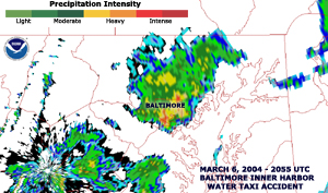 Radar Image Radar Image
|
In Australia, thunderstorms produced strong winds which gusted up to 130 km/hr (80 mph) across parts of the east coast of Queensland as well as the northern part of New South Wales. More than 70,000 homes were left without power and 3 people were killed by the storms (AFP).

 larger image larger image
|
Tropical Cyclone Evan formed in Australia's Gulf of Carpentaria on February 29 and moved across the island of Groote Eylandt on the 1st and then ashore along the east coast of the Northern Territory on the 2nd. Maximum sustained winds were near 75 km/hr (40 knots or 45 mph) as the cyclone came inland, accompanied by heavy rains.
|
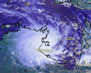
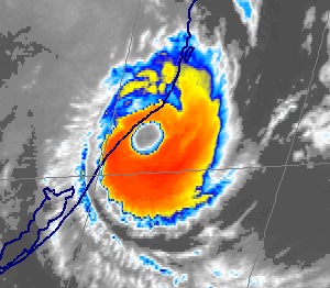
| Tropical Cyclone Gafilo developed in the South Indian Ocean on the 2nd and struck northern Madagascar on the 7th. Gafilo came ashore near Antalaha with maximum sustained winds near 260 km/hr (140 knots or 160 mph). In Antalaha, 95 percent of the houses were destroyed. The cyclone moved back over the Mozambique Channel before coming back across the southern part of the island nation on the 10th. In addition to the strong winds, torrential rain fell across much of Madagascar, and there were 300,000 rendered homeless (BBC News/AFP). There were 237 confirmed fatalities on the island, and a Comoran ferry sank with 113 people aboard with only 3 survivors accounted for (AFP/IFRC). Gafilo was the strongest tropical cyclone to hit Madagascar in ten years (IFRC). |
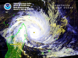 larger image larger image
|
 larger image larger image
|
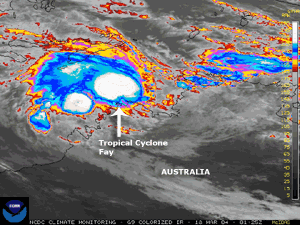
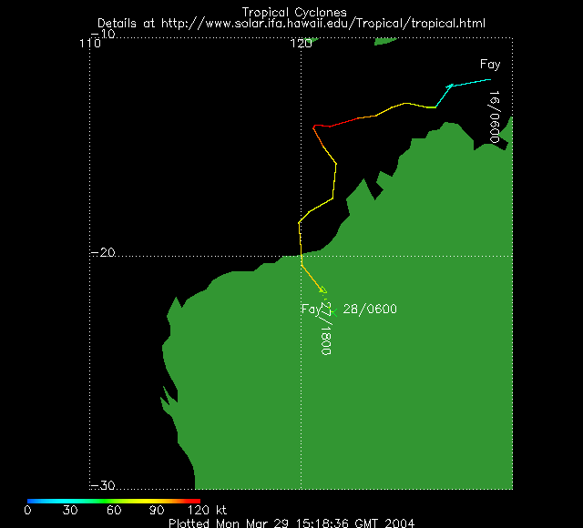
Tropical Cyclone Fay developed in the Timor Sea west of Bathurst Island on the 16th and drifted westward. The cyclone made landfall just east of Pardoo in Western Australia on the 27th with maximum sustained winds near 175 km/hr (95 knots or 110 mph). Heavy rain accompanied the cyclone well inland as it dissipated over the interior. |
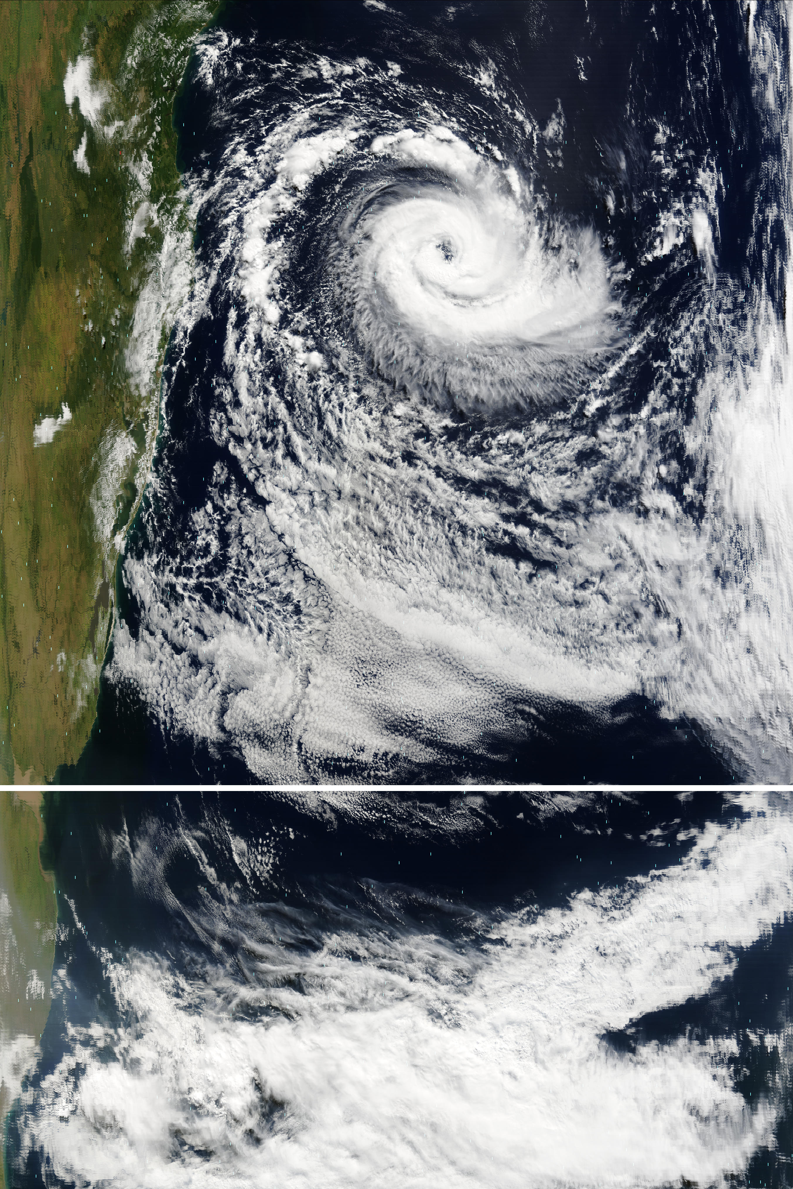
| The South Atlantic Hurricane developed from an extratropical cyclone that emerged off the coast of Brazil on the 20th. This nearly stationary non-tropical low pressure system acquired tropical characteristics and developed into a hurricane by the 26th. The hurricane made landfall along the southern coast of Brazil in the state of Santa Catarina just south of the resort town of Laguna early on the 28th. Maximum sustained winds were estimated between 120-130 km/hr (65 to 70 knots or 75 to 80 mph) with gusts to 155 km/hr (85 knots or 95 mph). The storm left at least three people dead and injured 38, while more than 2,000 were rendered homeless (Associated Press). This was the first documented hurricane in the South Atlantic Ocean since geostationary satellite records began in 1966. |
 Click For Animation (large loop) Click For Animation (large loop)
|
A table containing the Accumulated Cyclone Energy (ACE) index for global tropical cyclones occurring during the month of March 2004 is available.

No reports of significant extratropical cyclones were received during March 2004

 larger image larger image
|
In South Korea, a heavy snowstorm affected the country during March 4-6 and stranded around 4,000 motorists on highways. The central provinces of North and South Chungcheong received the heaviest single-day snowfall since 1904 when the country began collecting weather data (Reuters). Nearly 60 cm (2 feet of snow) accumulated in some central areas of the country.
|
Severe winter weather was blamed for 11 deaths during March 6-7 in Turkey. Avalanches and landslides were blamed for 8 deaths, while another 3 individuals were killed when an ice floe in floodwaters destroyed a bridge (Disasterrelief.org).
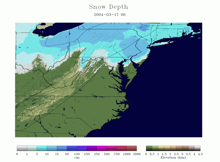
| A late-season winter storm affected the northern Mid-Atlantic and into the Northeast United States on the 16th. Snowfall accumulations of 15-25 cm (6-10 inches) were common across areas of Pennsylvania, New York and into southern New England. Boston, MA reported just over 18 cm (7 inches) of snowfall from the storm. |
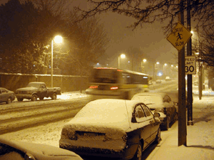 Boston Snowfall On March 16, 2004 Boston Snowfall On March 16, 2004
|
For detailed information on snowfall in the United States, see the U.S. Snow Page.
References:
Basist, A., N.C. Grody, T.C. Peterson and C.N. Williams, 1998: Using the Special Sensor Microwave/Imager to Monitor Land Surface Temperatures, Wetness, and Snow Cover. Journal of Applied Meteorology, 37, 888-911.
Peterson, Thomas C. and Russell S. Vose, 1997: An overview of the Global Historical Climatology Network temperature data base. Bulletin of the American Meteorological Society, 78, 2837-2849.
For all climate questions other than questions concerning this report, please contact the National Climatic Data Center's Climate Services Division:
For further information on the historical climate perspective presented in this report, contact:
Scott Stephens
NOAA/National Climatic Data Center
151 Patton Avenue
Asheville, NC 28801-5001
fax: 828-271-4328
email: Scott.Stephens@noaa.gov
-or-
Jay Lawrimore
NOAA/National Climatic Data Center
151 Patton Avenue
Asheville, NC 28801-5001
fax: 828-271-4328
email: Jay.Lawrimore@noaa.gov
 NCDC / Climate
Monitoring / Climate
of 2004 / Hazards / Search / Help NCDC / Climate
Monitoring / Climate
of 2004 / Hazards / Search / Help
http://www.ncdc.noaa.gov/oa/climate/research/2004/mar/hazards.html
Downloaded Saturday, 20-Sep-2008 12:17:53 EDT
Last Updated Tuesday, 29-Nov-2005 14:05:01 EST by Scott.Stephens@noaa.gov
Please see the NCDC Contact Page if you have questions or comments.
|


