 NCDC / Climate Monitoring / Climate of 2003 / East Pacific Hurricanes / Search / Help NCDC / Climate Monitoring / Climate of 2003 / East Pacific Hurricanes / Search / Help
Use these links to access detailed analyses of Global and U.S. data 
|


|
In the Eastern North Pacific, the season began slowly, though 16 named storms had developed as of the end of November. None of the storms reached hurricane strength until Hurricane Ignacio in late August. Seven storms had reached hurricane strength by the end of the season, though none of these reached 'major' status (category three on the Saffir Simpson Scale). This is the first year since 1977 since no hurricanes have reached category three strength. The 1966-1996 average for the Eastern Pacific is for 16.4 storms to form, with nine hurricanes, so the Eastern North Pacific hurricane season was near average in terms of the number of storms, but the storms were of a lower intensity than the average. Five storms made landfall on Mexico's Pacific coast in 2003. Marty and Ignacio were at hurricane strength when they came ashore in Baja California during August and September, respectively. Carlos in June and Olaf in September were at tropical storm strength when they impacted mainland Mexico, while Nora had weakened to a tropical depression when it came ashore in Northern Mexico in October. Marty was also a tropical depression as it affected mainland Mexico after crossing Baja California at hurricane strength. No tropical cyclones formed in November. The Eastern North Pacific season runs from May 15th-November 30th. |
 October
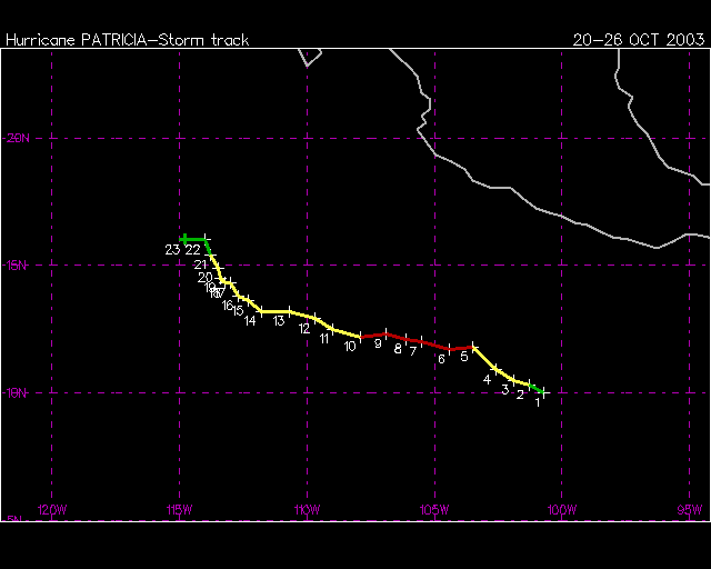
| In October 2003, three tropical storms formed in the eastern Pacific, all of which reached hurricane strength. Hurricanes Olaf and Nora came ashore in Mexico, while short-lived Hurricane Patricia did not make landfall. |
 larger image larger image
|
Hurricane Olaf formed as a tropical depression on the 3rd in the eastern Pacific Ocean south of Acapulco, Mexico. Olaf peaked with maximum sustained winds near 120 km/hr (65 knots or 75 mph) before weakening prior to landfall. Olaf crossed into Mexico near Manzanillo as a 95 km/hr (50 knots or 60 mph) tropical storm on the 7th. |
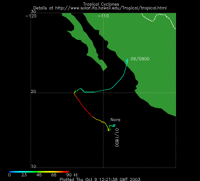
| Hurricane Nora developed as a tropical depression in the eastern Pacific Ocean on the 1st. Nora reached maximum intensity over open waters on the 4th with maximum sustained winds near 165 km/hr (90 knots or 100 mph). Nora weakened to a depression before moving inland early on the 9th near Mazatlan, Mexico. |  larger image |
September
| Tropical Storm Kevin began as a depression on September 3rd about 250 n mi southwest of Cabo San Lucas, Mexico and moved parallel to the Baja California Peninusula becoming a tropical storm on the 4th. Since Kevin formed at a fairly high latitude, its life cycle was short and it quickly weakened back to a depression on the 5th. Hurricane Linda formed from a wave that moved off the coast of Central America on the 6th, becoming a tropical depression on the 14th, and a hurricane on the 15th. Linda weakened back to a depression on the 16th and continued to weaken as it moved southwestward. |
 larger image larger image
|
Hurricane Marty developed as a tropical depression in the eastern Pacific Ocean on the 19th. Marty made landfall along Mexico's Baja Peninsula on the 22nd near San Jose del Cabo with maximum sustained winds near 160 km/hr (85 knots or 100 mph). Marty weakened as it tracked northward across the Gulf of California, spreading heavy rains as far north as Arizona by the 24th. Marty was responsible for 10 deaths, and was the second hurricane in less than a month to affect Baja California (Reuters/AFP). |
August
| Four tropical systems developed during August with two reaching hurricane strength. Hurricane Ignacio developed off the west coast of Mexico on the 21st and became a hurricane by the 24th as it entered the Gulf of California. Ignacio made landfall along Mexico's Baja Peninsula on the 26th, along with very heavy rainfall and maximum sustained winds near 65 knots (75 mph 120 km/hr). The storm battered the city of La Paz for more than 48 hours with strong winds and flooding rains. By the 27th, Ignacio had weakened into a tropical depression as it tracked over the central Baja Peninsula. |  larger image |
|
A tropical depression developed in the eastern Pacific on August 7th, strengthening to become Tropical Storm Guillermo on the 8th. Peak wind speeds of 50 kts (58 mph/93 kph) were reached later that day for Guillermo. By the 10th, Guillermo was weakening and the storm became a depression again on the 11th. Tropical Storm Hilda was active at the same time as Guillermo but was weaker reaching only 35 kts (40 mph/65 kph)at its peak on August 9th. Hilda weakened on the 11th and had dissipated by the 13th. A system which formed later in the month developed into Hurricane Jimena, eventually threatening the Hawaiian islands. Jimena became a tropical storm on August 28th and quickly reached hurricane strength the following day about 1300 miles east of Hilo, Hawaii. Maximum windspeeds of 90 kts (104 mph/167 kph) were reached on August 30th (category 2 on the Saffir-Simpson scale). The storm passed close to the Big Island of Hawaii on September 1st, but weakened into a tropical storm as it did so. Damage was light on the Big Island though as many as 1,500 residents were without power and rainfall amounts ranged from 3.74 inches (95 mm) at Hilo Airport to 6.42 inches (163 mm) at Mountain View (NWS/CPHC) |
July
So far this season (as of July 31), 6 tropical storms have formed, which is near average, however, climatologically, 3 hurricanes could be expected by July 31. None of these 6 tropical storms developed into hurricanes by the end of July.  larger image |
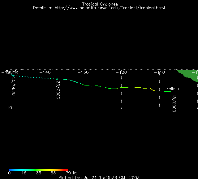
During July, 3 tropical storms developed in the eastern North Pacific. A weak and short-lived tropical storm, Tropical Storm Dolores, formed on July 6th, but weakened back to a depression early on the 7th, before meandering gradually northwestward and dissipating to become a remnant low on the 8th. Tropical Depression #5E became Tropical Storm Enrique on July 11. Enrique maintained strong convection and reached a maximum windspeed of 55 kts (102 kph/63 mph), but was unable to reach hurricane intensity before moving over colder sea surface temperatures and weakening on the 12th and 13th. Tropical Storm Felicia began as a disorganized tropical depression off the Manzanillo, Mexico coast on July 17th. Reaching tropical storm strength on the 18th, Felicia appeared as though it might strengthen to become the first hurricane of the eastern North Pacific season, but Felicia became somewhat disorganized and reached maximum windspeeds of only 45 kts (83 kph/52 mph) before weakening over cooler waters early on the 20th.
|
June
 larger image |
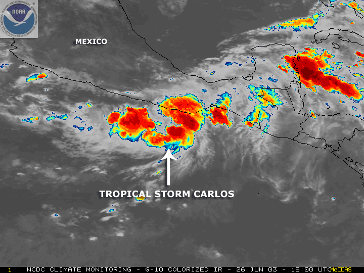
The second and third tropical storms of the season in the eastern North Pacific formed during June. Tropical Storm Blanca formed about 260 miles south-southeast of Manzanillo, Mexico and reached maximum windspeeds of 55 knots (63 mph) on June 18. Blanca did not move far from its point of origin and never threatened land. T.S. Carlos came ashore near Puerto Escondido on June 27 as a 55 kt (63 mph) tropical storm. It had formed on June 25 about 200 miles south-southeast of Acapulco. After making landfall, Carlos quickly dissipated.
|
May
 larger image |
The eastern North Pacific hurricane season officially begins on May 1st, generally peaks in late August/early September and concludes around the beginning of November. On May 20th, a tropical depression approximately 650 miles south of Manzanillo, Mexico became the first tropical storm of the 2003 season for the eastern North Pacific. Tropical Storm Andres reached maximum windspeeds of 40 knots (46 mph) and never threatened land. T.S. Andres was downgraded to a depression on the 24th.
|
Useful Links
Questions?
For all climate questions other than questions concerning this report, please contact the National Climatic Data Center's Climate Services Division:
|
Climate Services Division NOAA/National Climatic Data Center 151 Patton Avenue Asheville, NC 28801-5001 fax: 828-271-4876 phone: 828-271-4800 email: questions@ncdc.noaa.gov |
For further information on the historical climate perspective presented in this report, contact:
|
Jay Lawrimore NOAA/National Climatic Data Center 151 Patton Avenue Asheville, NC 28801-5001 fax: 828-271-4328 email: Jay.Lawrimore@noaa.gov |
NCDC / Climate Monitoring / Climate of 2003 / hurricanes / Search / Help
Downloaded Sunday, 21-Sep-2008 07:47:09 EDT
Last Updated Friday, 18-Nov-2005 14:12:19 EST by Anne.Waple@noaa.gov
Please see the NCDC Contact Page if you have questions or comments.