 NCDC / Climate Monitoring / Climate of 2004 / Snow Summary / Search / Help NCDC / Climate Monitoring / Climate of 2004 / Snow Summary / Search / Help
Use these links to access detailed analyses of Global and U.S. data. 
|


| The map to the right shows the percent average snowfall for the 2003-2004 winter season, as of the beginning of May. Below average seasonal snowfall generally occurred in the far eastern Mississippi Valley through the Tennessee Valley. Less than average seasonal snowfall was also evident in parts of the South, Colorado and western Kansas as well as patchy areas of the West. Above average snow amounts were recorded along much of the Appalachian chain, southwest Iowa, parts of the West and the northern Great Plains. |  larger image |
 larger image
|
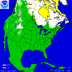
The map to the left shows snow cover on April 29th after a snow storm left 3-6 inches of snow across much of western Wyoming, with locally greater amounts in the higher elevations. When the map is animated, it shows the continental retreat of snow cover over the month of April. Snow retreated rapidly and was below average across most of the West at the end of April, partly in response to a large ridge of high pressure and near record temperatures across much of the far West. At the beginning of May, snow and ice remained in the high regions of the Rockies and in eastern Canada. Hudson Bay was still frozen as of the end of April, though no significant ice remained across the Great Lakes. |
|
See NCDC's snow monitoring page for the latest snow totals and the snow climatology pages for snow statistics for U.S. states and stations. |
 March
March
| The map to the right shows departures from average (in percent) for March snowfall totals across the US. Parts of the Northeast (from Ohio to Massachusetts) received above average snowfall for the month as well as areas of the upper Midwest and southwest Iowa. However, seasonal snowfall departures show that snow totals were below average for several areas of the country, including much of New England, the Lower Great Lakes, especially around Chicago, and the southwestern Great Plains. Areas of above average seasonal snowfall include North Carolina and the Appalachian Range, southwest Iowa and parts of the Northern Plains. |  larger image |
 larger image
|
The image to the left shows the snow depth on March 17th, 2004, after a snowstorm in the Northeast left 6-10 inches of snow from Pennsylvania through southern New England. Over 7 inches of snow fell in Boston from the storm. |
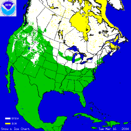
| The map to the right shows snow cover on March 16th after a late winter storm left much of the Northeast under 6-10 inches of snow. When the map is animated, it shows the continental retreat of snow cover over the month of March. Snow remained in the far Northeast and upper elevations of the West but generally decreased across the North American continent with the onset of spring. Snow melt was especially severe across much of West with the snowpack diminishing to much below average conditions by the beginning of April. |
 larger image
|
|
See NCDC's snow monitoring page for the latest snow totals and the snow climatology pages for snow statistics for U.S.states and stations. |
February
| The map to the right shows departures from normal (in percent) for February snowfall totals across the US. The Northeast received much less snow than normal for the month while areas of the Midwest and the Southeast had above average snowfall. However, seasonal snowfall departures show that snow totals across the Northeast relative to the long-term mean were above average, with less than average seasonal snow amounts being confined to the southern Wisconsin area and the High Plains spreading into the Rocky Mountains and southeastern Oklahoma. |  larger image |
 larger image
|
The image to the left shows the snow depth on February 12th, 2004, after a blizzard on the 11th left parts North Dakota with 20 foot drifts of snow. The blizzard conditions, created by heavy snow and gusts of up to 70 mph, prompted the governor of North Dakota to declare a snow emergency. The monthly total snowfall record was also broken for Pocotello, ID in February. A total of 30.5 inches fell during the month breaking the old record by over 7 inches. |
| Parts of North and South Carolina also received heavy snow in February with near record amounts falling in the Charlotte Metropolitan area on the 26th. It was Charlotte's third largest snow storm on record for a calendar day, with 11.6 inches observed at the airport and up to 20 inches recorded elsewhere in and around the city. |
 larger image
|
|
See NCDC's snow monitoring page for the latest snow totals and the snow climatology pages for snow statistics for U.S.states and stations. |
January
| The map to the right shows departures from normal (in percent) for seasonal snowfall totals across the US. Most areas of the country received near average or much above average snowfall for the season as of January 31st. Areas of much above average snowfall include the Northeast, especially western areas of the Northeast (NY, PA), and parts of the northern Great Plains, with snowfall as much as 200% above normal. |  larger image |
 Click here for animated image
|
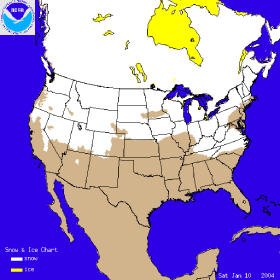
The image to the left shows the snow cover on January 10th, 2004, after a storm left parts the east coast blanketed in snow. Another storm late in the month (26th) left over a quarter of a million people without power after snow and ice swept across Georgia and the Carolinas. At least 14 people died in storm-related accidents (Reuters). The same storm dumped up to a foot of snow in parts of the Northeast, while areas of the Midwest (especially Minnesota) received over a foot of snow in a separate storm during the same period. Extreme lake effect snows impacted areas of western New York state with some parts of Oswego County, NY recording over 130 inches of snow for the month and over 3 feet for a single 3-day event near the end of January. |
December
| The map to the right shows snowfall totals in inches from a storm which tracked across the Northeast between December 5th and December 7th. The National Weather Service 24-hour snow totals and other information on the storm can be found at the Taunton, MA NWS office. |  larger image |
 Click here for animated image
|
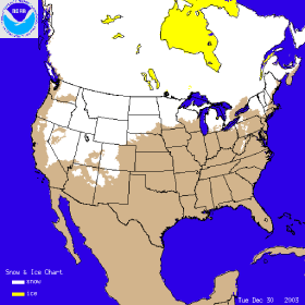
The image to the left shows the snow cover on December 30th 2003 after a series of snow storms left much the West covered in many feet of snow. Over 6 feet (2 meters) of snow fell on Utah's Salt Lake City leading to avalanches in the surrounding area and loss of electrical power for many residents. A fast moving snow storm caused 150 miles of Interstate 5 through northern California/southern Oregon to be closed on December 28th and 29th. As much as 2 feet of snow fell along parts of the highway with drifts of 6-7 feet stranding motorists overnight with little food or water. |
|
See NCDC's snow monitoring page for the latest snow totals and the snow climatology pages for snow statistics for U.S. states and stations. |
November
 larger image |
The first significant snowfall of the 2003-2003 winter season arrived early in November across parts of Montana, Wyoming and the Dakotas. |
| A strong storm system that moved across the U.S. Great Lakes and into Quebec during the 12th-13th produced a variety of weather impacts, including severe thunderstorms, strong winds and heavy snows. Winds gusting to 80-95 km/hr (50-60 mph) across the Ohio Valley, Great Lakes, Northeast and Mid-Atlantic knocked out power to over 200,000 customers in the region (Associated Press). Heavy snows affected areas of southeastern Canada, including Quebec, while snow also fell downwind of the Great Lakes. |  larger image larger image
|
 Click here for animated image
|
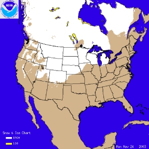
The image to the left shows the snow cover on November 24th 2003 after the most significant storm outside of the mountains this year left parts of the North Central region of the country with more than 10 inches of snow. Click on the image for an animation of daily snowcover throughout the month of November. |
|
See NCDC's snow monitoring page for the latest snow totals and the snow climatology pages for snow statistics for U.S.states and stations. |
Questions?
For all climate questions other than questions concerning this report, please contact the National Climatic Data Center's Climate Services Division:
| Climate Services Division NOAA/National Climatic Data Center 151 Patton Avenue Asheville, NC 28801-5001 fax: 828-271-4876 phone: 828-271-4800 email: questions@ncdc.noaa.gov |
For further information on the historical climate perspective presented in this report, contact:
|
Jay Lawrimore NOAA/National Climatic Data Center 151 Patton Avenue Asheville, NC 28801-5001 fax: 828-271-4328 email: Jay.Lawrimore@noaa.gov |
NCDC / Climate Monitoring / Climate of 2004 / Snow Summary / Search / Help
Downloaded Sunday, 12-Oct-2008 01:59:30 EDT
Last Updated Friday, 18-Nov-2005 14:12:24 EST by Anne.Waple@noaa.gov
Please see the NCDC Contact Page if you have questions or comments.