

| Return to Satellite Home | ||
SSMI and SSMIS Monitoring and Documentation |
||
| Summary | Details and Documents | Contact |
|
|
||
Summary |
||
Data from the Special Sensor Microwave Imager (SSMI) instrument is collected under the Defense Meteorological Satellite Program (DMSP), which is a Department of Defense (DoD) program responsible for designing, building, launching, and operating polar-orbiting environmental satellites. By the year 2010 the military and civilian operational meteorological satellite systems will be merged into a single, national program. This program is known as the National Polar-orbiting Operational Environmental Satellite System (NPOESS), and is designed to employ three or more satellites to integrate remote sensing, surface data collection, and search and rescue payloads. This system will replace both the Polar-orbiting Operational Environmental Satellite (POES) and the DMSP series. |
||
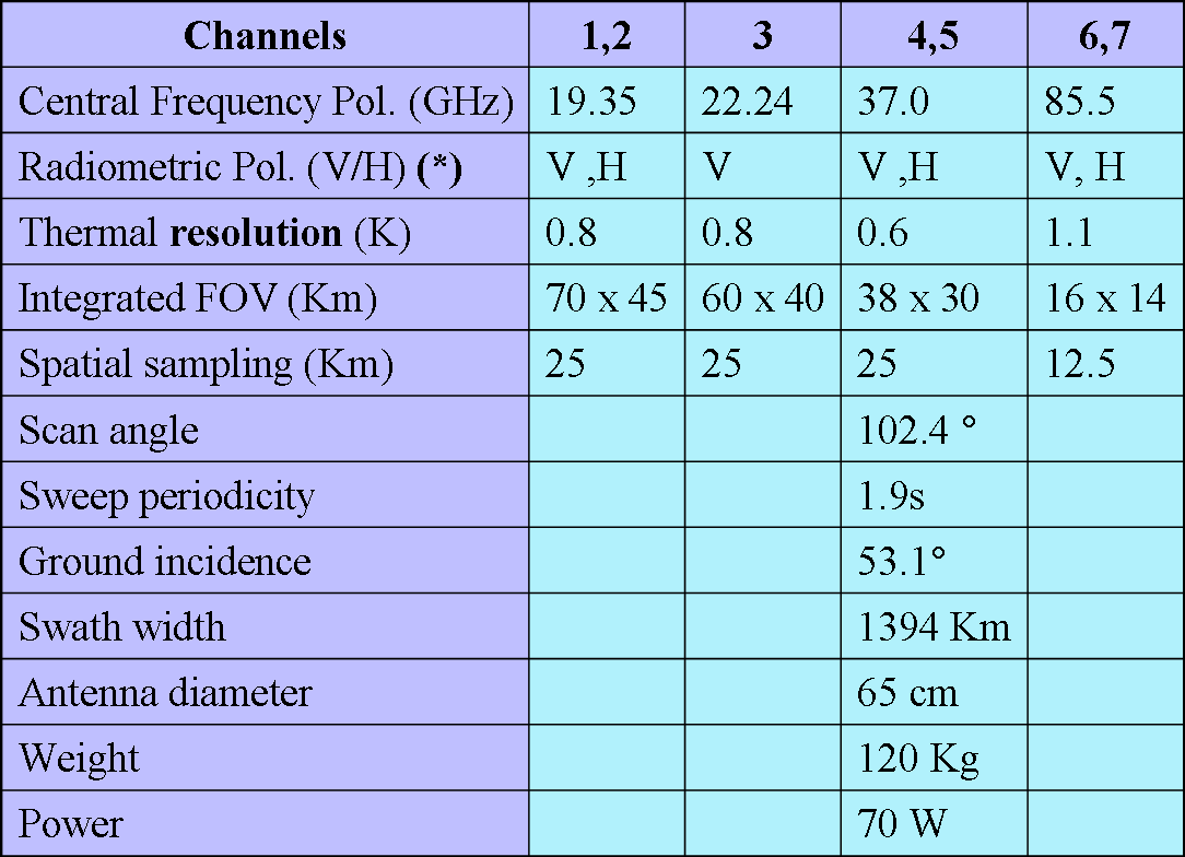
The Special Sensor Microwave Imager (SSMI) is a seven channel, four frequency, linearly-polarized, passive microwave radiometric system which measures atmospheric, ocean, and terrain microwave brightness temperatures at 19.35, 22.24, 37.00, and 85.80. NOAA's National Climatic Data Center (NCDC) is undertaking the task of recovering SSMI data starting from the first successful launch of the F-8 platform in 1987. |
||
The first Special Sensor Microwave Imager/Sounder (SSMIS) sensor is onboard the DMSP F-16 platform that was launched on 18 October 2003 and became operational in November 2005. The SSMIS sensor is a passive conically scanning microwave radiometer that combines and extends the current imaging and sounding capabilities of three previously separate DMSP microwave sensors: the SSM/T-1 temperature sounder, the SSMI/T- 2 moisture sounder, and the SSMI. The SSMIS instrument measures microwave energy at 24 discrete frequencies from 19 to 183 GHz with a swath width of 1700 km. |
||
|
|
||
Details and Documents |
||
Original Navy-NESDIS SSMI Data Information
Original Navy-NESDIS SSMIS Data InformationDetailed spectral or channel information can be found in this table and this table. The SSMIS Temperature Data Record (TDR) document describes antenna temperature data. The Sensor Data Record (SDR) document describes brightness temperature data. Other relevant documents for the SSMIS instrument are:
NOAA Center for Satellite Applications and Research (STAR) Recalibrated SSMIS TDR Data (HDF-EOS format)
Other possible changes in data formats are currently being investigated. In the near future, SSMI and SSMIS TDR/SDR data will be provided in a netCDF format.
|
||
|
Data Access |
||
|
|
||
Contact |
||
|
Satellite Services Group |
||
   Downloaded Tuesday, 16-Sep-2008 08:06:56 EDT Last Updated Wednesday, 25-Jul-2007 10:28:40 EDT by Hilawe.Semunegus@noaa.gov Please see the NCDC Contact Page if you have questions or comments. |