Tropical Cyclone Report
Tropical Storm Matthew
8 - 10 October 2004
Lixion A. Avila
National Hurricane Center
27 October 2004
Matthew made landfall on the Louisiana
coast as a tropical storm with 35 kt winds.
a. Synoptic History
The origin of Matthew can be traced to a
tropical wave that moved across the west coast of Africa on 19
September. The wave was very difficult to track between Africa and
the Lesser Antilles because its close proximity to
Tropical Storm Lisa
and another large disturbance in the tropical Atlantic. The
wave crossed the Lesser Antilles on 29 September and began to
interact with a westward moving upper-level low. Cloudiness and
showers gradually increased as the wave moved very slowly westward,
trailing the upper-level low. The shower activity associated with
the wave reached the Bay of Campeche on 5 October and gradually
became better organized while moving little. An upper-level ridge
became established over the convection and surface pressures began
to fall in the area. On 7 October, data from a reconnaissance
aircraft indicated a broad area of low pressure had formed just
east of Tampico, Mexico, accompanied by light winds. The system
continued to become better organized while moving little, and it is
estimated that a tropical depression formed at 1200 UTC 8 October
about 180 n mi southeast of Brownsville Texas. By 1800 UTC that day
the cyclone strengthened into Tropical Storm Matthew. Initially,
the cyclone moved toward the east and east-northeast, but then
gradually turned to the northeast and north steered by a large mid-
to upper-level low over western Texas. It is estimated that Matthew
reached its peak intensity of 40 knots and a minimum pressure of
997 mb at 1800 UTC 9 October. Matthew's center made landfall just
west of Cocodrie, Louisiana about 1100 UTC 10 October. Maximum
estimated winds were then 35 knots. Thereafter, Matthew weakened to
a depression and became an extratropical low. It continued moving
northward and was absorbed by a frontal system at 1200 UTC 11
October.
The "best track" chart of the tropical
cyclone's path is given in Figure 1, with the wind and pressure
histories shown in Figure 2 and Figure 3, respectively. The best track
positions and intensities are listed in Table 1.
b. Meteorological Statistics
Observations in Matthew (Figure 2 and Figure 3)
include satellite-based Dvorak technique intensity estimates from
the Tropical Analysis and Forecast Branch (TAFB), the Satellite
Analysis Branch (SAB) and the U. S. Air Force Weather Agency
(AFWA), as well as flight-level observations from flights of the
53rd Weather Reconnaissance Squadron of the U. S. Air
Force Reserve Command. Microwave satellite imagery from NOAA
polar-orbiting satellites, the NASA Tropical Rainfall Measuring
Mission (TRMM), the NASA QuikSCAT, and Defense Meteorological
Satellite Program (DMSP) satellites were also useful in tracking
Matthew.
Table 2 shows selected surface observations
including reports from southern Louisiana of heavy rainfall. The
maximum rainfall was reported at Reserve in St. John Parish with
16.23 inches.
c. Casualty and Damage Statistics
One tornado briefly occurred near Golden
Meadow, damaging the roof of a trailer. In Terrebonne Parish about
20 homes were flooded by the combination of rains and storm surge.
There was a report of a 5.85 ft surge at Frenier as indicated in
Table 2. According to local newspapers, Grand Isle suffered
extensive beach front erosion. There were no known deaths or
injuries.
d. Forecast and Warning Critique
Matthew was a short-lived tropical cyclone
and there were only a few forecasts to verify. The few track
forecasts produced errors are comparable to the average official
track errors for the 10-yr period 1994-2003. The average official
intensity errors were smaller than the average official intensity
errors over the same period.
A strong pressure gradient prevailed over
the northeastern Gulf of Mexico and produced gale force winds in
that area during the formation of Matthew. As the circulation of
the tropical cyclone headed for the coast, a tropical storm warning
was issued from the Alabama-Florida border westward to Intracoastal
City, Louisiana at 2100 UTC 9 October. The tropical storm warning
replaced the existing gale warning about 15 hours before the
poorly-defined center of Matthew crossed the Louisiana coast. The
warning was discontinued at 1500 UTC 10 October.
Table 1: Best track for Tropical Storm
Matthew, 8-10 October, 2004.
Date/Time
(UTC) | Position | Pressure
(mb) | Wind Speed
(kt) | Stage |
Lat.
(°N) | Lon.
(°W) |
| 08 / 1200 | 24.0 | 95.4 | 1007 | 30 | tropical depression |
| 08 / 1800 | 24.1 | 94.2 | 1004 | 35 | tropical
storm |
| 09 / 0000 | 24.6 | 93.7 | 1000 | 40 | " |
| 09 / 0600 | 25.3 | 93.2 | 1002 | 35 | " |
| 09 / 1200 | 26.3 | 92.8 | 1002 | 35 | " |
| 09 / 1800 | 26.8 | 92.0 | 997 | 40 | " |
| 10 / 0000 | 27.3 | 91.4 | 998 | 40 | " |
| 10 / 0600 | 28.1 | 91.2 | 999 | 40 | " |
| 10 / 1200 | 29.4 | 90.9 | 1000 | 30 | tropical
depression |
| 10 / 1800 | 30.4 | 90.9 | 1002 | 25 | " |
| 11 / 0000 | 32.0 | 91.0 | 1003 | 25 | extratropical |
| 11 / 0600 | 33.6 | 91.9 | 1005 | 20 | " |
| 11 / 1200 | | | | | Absorbed by front |
| 10 / 1100 | 29.2 | 91.0 | 999 | 35 | Landfall near Cocodrie, LA. |
| 09 / 1800 | 26.8 | 92.0 | 997 | 40 | minimum pressure |
Table 2: Selected surface and coastal
observations for Tropical Storm Matthew, 8-10 October, 2004.
| | Minimum
Sea-level
Pressure | Maximum Surface Wind Speed
(kt) | |
| Location | Date/
Time
(UTC) | Press.
(mb) | Date/
Timea
(UTC) | Sust.
Windb
(kts) | Peak
Gust (kts) | Storm
Surgec
(ft) | Storm
Tided
(ft) | Rain
(storm total)
(in) |
| Louisiana |
| New Orleans Lakefront Airport | 10/1205 | 1003.7 | 10/1306 | 33 | 41 | | | 4.06 |
| BURLI (CMAN) | 10/1200 | 1004.0 | 10/0940 | 42 | 48 | | | |
| Grand Isle GDIL1 (CMAN) | 10/1100 | 1002.8 | 10/0927 | | 40 | 3.61 | | |
| Lumcon | 10/1000 | 1001.7 | 10/0200 | | 34 | | | |
| LSU Agricultural Stn. Citrus | | | 10/1506 | | 38 | | | 5.47 |
| Tambour Bay | 10/1000 | 999.7 | | | | | | |
| Cocodrie | | | | | | 3.7 | | |
| NWS Mandeville | | | | | | 5.3 | | |
| NWS Frenier | | | | | | 5.85 | | |
| Slidell KASD | | | | | | | | 5.16 |
| Baton Rouge KBTR | | | | | | | | 7.42 |
| New Orleans KMSY | | | | | | | | 7.50 |
| Galliano | | | | | | | | 14.28 |
| Thibodaux | | | | | | | | 9.43 |
| LSU Agricultural Stn Sugarcane | | | | | | | | 13.02 |
| Houma | | | | | | | | 8.86 |
| Paradis | | | | | | | | 8.68 |
| Reserve | | | | | | | | 16.23 |
aDate/time is for sustained
wind when both sustained and gust are listed.
bExcept as noted, sustained
wind averaging periods for C-MAN and land-based ASOS reports are 2
min; buoy averaging periods are 8 min.
cStorm surge is water height
above normal astronomical tide level.
dStorm tide is water height
above National Geodetic Vertical Datum (1929 mean sea level). |
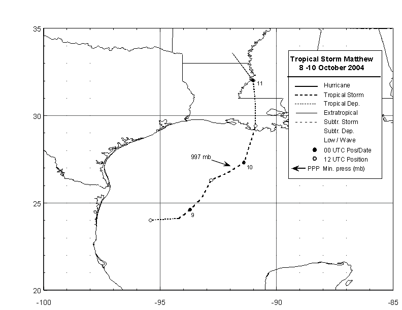
Figure 1:
Best track positions for
Tropical Storm Matthew, 8-10 October, 2004.

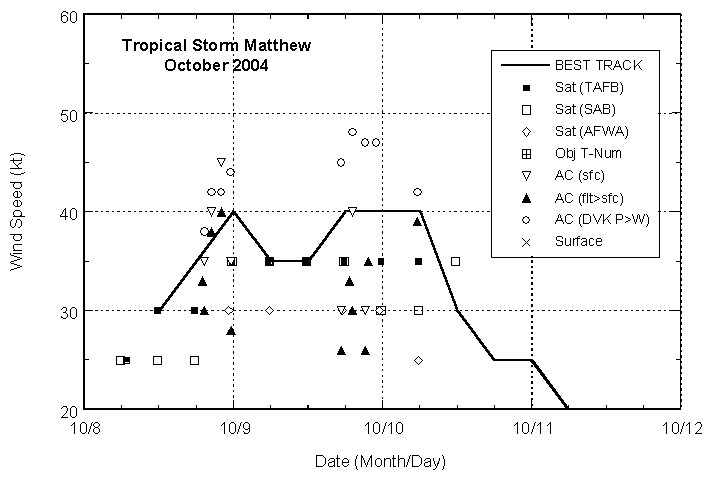
Figure 2:
Selected wind observations and
best track maximum sustained surface wind speed curve for Matthew,
8-10 October, 2004. Aircraft observations have been adjusted for
elevation using 80%, reduction factors for observations from 1500
ft or less.

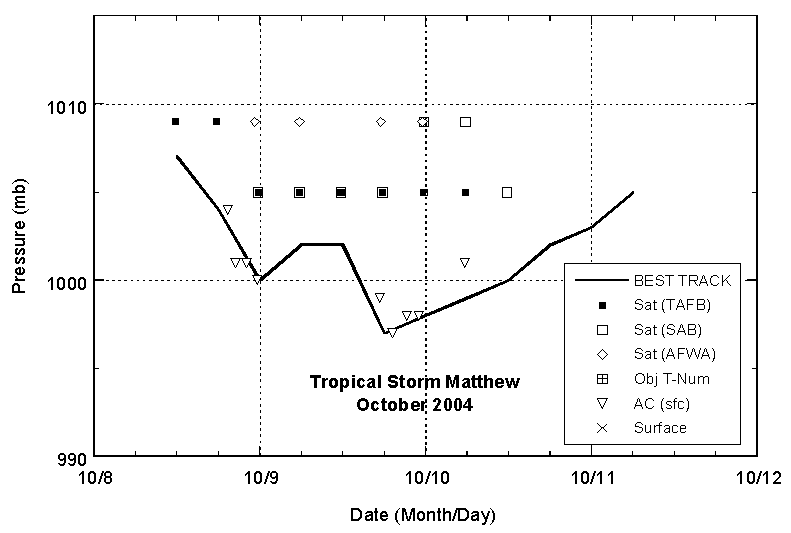
Figure 3:
Selected pressure observations
and best track minimum central pressure curve for Tropical Storm
Matthew, 8-10 October, 2004.
|