Tropical Cyclone Report
Hurricane Jeanne
13 - 28 September 2004
Jeanne produced heavy rain over Guadeloupe,
Puerto Rico and the Dominican Republic and caused an estimated 3000
or more deaths in Haiti, from torrential rainfall flooding.
Finally, Jeanne hit the northern Bahamas and then the central
Florida east coast as a category three hurricane.
a. Synoptic History
Jeanne formed from a tropical wave that moved
from Africa to the eastern tropical Atlantic Ocean on 7 September.
The wave moved uneventfully across the Atlantic until a tropical
depression formed from it on 13 September as it approached the
Leeward Islands. Jeanne's best track begins at 1800 UCT on this day
and the "best track" chart of the tropical cyclone's path is
plotted in Figure 1. Maximum 1-min. wind speeds and minimum central
surface pressure histories are shown in Figure 2 and Figure 3,
respectively. All of the best track data are listed in Table 1.
From 13 to 18 September, the motion was toward
the west-northwest at a slow forward speed of 5 to 10 kt, under the
steering flow of a subtropical high pressure ridge located to
Jeanne's north. The cyclone strengthened to a tropical storm on 14
September while it moved slowly over the Leeward Islands.
Continuing west-northwestward, its circulation moved slowly over
the Virgin Islands and the center moved inland over southeastern
Puerto Rico on 15 September when maximum sustained surface winds
reached 60 kt. The center moved across Puerto Rico, then over the
Mona Passage and inland at the eastern tip of the Dominican
Republic. Jeanne was a hurricane with 70-kt winds while over the
Mona Passage and during the Dominican Republic landfall, but then
weakened over the rough terrain of Hispaniola. By 1800 UTC on 17
September, the cyclone briefly weakened to a depression and moved
over Atlantic waters just north of Hispaniola. On 18 September and
in a weakened condition, the low level center moved westward away
from the deep convection and dissipated and a new center reformed
well to the northeast of the dissipated old center. Jeanne's slow
forward motion across the Caribbean motion contributed to
torrential rainfall along its path. These rains and resultant
fresh-water flooding and mudslides caused thousands to die in
Haiti.
While Jeanne was dumping rain over the
Caribbean countries, Hurricane Ivan
moved over the Gulf of Mexico
and inland across the southeastern United States. By 18 September,
Ivan's mid-level circulation had combined with an extratropical
short wave trough in the westerlies and moved to the northeastern
U.S. coast where it eroded the ridge to the north of Jeanne. This
placed Jeanne in a weak steering flow that persisted for five days.
Jeanne first moved slowly northward over the southeastern Bahamas
as a tropical storm and then moved in an anticyclonic loop about
500 n mi east of the northwestern Bahamas. Jeanne gradually
strengthened to a hurricane with 85-kt winds by the time it
completed this loop on 23 September.
By 23 September, the extratatropical trough
previously located over the northeastern U.S. coast moved eastward
and was replaced by a large deep-layer migratory ridge that
propelled Jeanne on a track just north of due westward. On 24
September, Jeanne moved over its own previous track from a few days
earlier and encountered cooler waters caused by upwelling from the
hurricane. This is believed to be a factor in the decreasing of the
maximum winds from 85 kt to 70 kt by 0000 UTC on 24 September.
Continuing westward at 10 to 12 kt and moving away from the
upwelled cooler water, the winds increased to 100 kt (category
three on the Saffir/Simpson hurricane scale) by 1200 UTC on 25
September as the center moved over Abaco Island and then Grand
Bahama Island in the northern Bahamas. Jeanne made landfall on the
east coast of Florida early on 26 September with the center of its
50-n mi diameter eye crossing the coast at the southern end of
Hutchinson Island just east of Stuart at 0400 UTC on 26 September.
Maximum winds at landfall are estimated at 105 kt over a very small
area north of the center and it is not clear whether these
strongest winds reached the coast or remained over water.
Jeanne moved across central Florida while
weakening and began to recurve around the western periphery of the
migratory ridge mentioned above. The hurricane weakened to a
tropical storm while centered about 30 n mi north of Tampa at 1800
UTC on 26 September and then weakened to a tropical depression
about 24 h later while moving northward across central Georgia
accompanied by heavy rain. The depression, still accompanied by
heavy rain moved over the Carolinas, Virginia, and the Delmarva
Peninsula. It merged with a frontal zone and became extratropical
at 0000 UTC on 29 September while moving eastward off of the U.S
mid-Atlantic coast.
b. Meteorological Statistics
Wind and pressure observations in Jeanne
(Figure 2 and Figure 3)
include satellite-based Dvorak technique intensity
estimates from the Tropical Analysis and Forecast Branch (TAFB),
the Satellite Analysis Branch (SAB) and the U. S. Air Force Weather
Agency (AFWA), as well as flight-level and dropwindsonde
observations from flights of the 53rd Weather Reconnaissance
Squadron of the U. S. Air Force Reserve Command. Microwave
satellite imagery from NOAA polar-orbiting satellites, the NASA
Tropical Rainfall Measuring Mission (TRMM), the NASA QuikSCAT, and
Defense Meteorological Satellite Program (DMSP) satellites were
also useful. Ship reports of winds of tropical storm force and
higher associated with Jeanne are given in Table 2, and selected
surface observations from land stations and data buoys are given in
Table 3.
Unofficial reports indicate that Jeanne was
responsible for 8 to 12 in of rainfall over Guadeloupe and nearby
islands.
Jeanne made landfall as a tropical storm
around 1600 UTC on September 15 across the southeastern coast of
Puerto Rico. The observing site at San Juan Airport recorded a
sustained wind of 43 kt and the St. Croix Airport reported a
sustained wind of 45 kt. The highest reported storm total rainfall
amount over the area was at Camp Garcia in Vieques, which recorded
23.75 in. Generally, total rainfall amounts averaged from 5 to 15
in with some locally higher amounts. This magnitude of rainfall
produced major and historical flooding at many river forecast
points within Puerto Rico. The U.S. and British Virgin Islands also
experienced heavy flooding as implied by two reports of over 12 in
of rain from St. Thomas.
Jeanne produced torrential rains and tropical
storm force winds across much of Hispaniola, with the possibility
of hurricane force winds over extreme eastern Dominican Republic.
Although no rainfall observations are available, some areas of
Haiti, especially in Gonaives, were completely devastated from
massive flooding and mudslides.
The highest best track estimated 1-min surface
winds are 105 kt from 1800 UTC to 0000 UTC on 25 and 26 September.
The hurricane was moving across Grand Bahama Island and nearing the
Florida east coast during this time. The value of 105 kt is based
primarily on aircraft wind speeds of 113 kt measured at a flight
level of 700 mb at 1429 UTC on 25 September and again at 0228 UTC
on 26 September, reduced to a surface value of 102 kt using a 0.90
reduction factor. This wind speed estimate is for an "over water"
wind. The aircraft wind observed at 0228 UTC was at a location
about 35 n mi north of the center of the eye and just offshore of
the Florida east coast east of Sebastian. It is possible that wind
speeds of near 105 kt may have affected a small area of the
coastline in the vicinity of Sebastian, although there are no
surface observations at the coast to confirm this. In addition,
Step frequency microwave radiometer wind measurements of up to 99
kt were obtained from a NOAA aircraft just prior to landfall. Wind
speeds of the same magnitude are expected to have also affected
portions of Grand Bahama and Abaco Islands.
Table 3 lists several locations that reported
hurricane force sustained winds of 64 kt or greater. The highest
sustained surface wind reported was 79 kt at the Melbourne NWS
office. This was observed at 0818 UTC when the center was about 45
n mi southwest of Melbourne. A measurement of 69 kt was taken on
the north shore of Lake Okeechobee by the South Florida Water
Management District at 0515 UTC. A C-MAN station at Settlement
Point, Grand Bahama Island reported 77 kt at 0000 UTC on 26
September when the center was located about 35 n mi northwest of
the station. The observations indicate that a swath of hurricane
force sustained winds about 90 n mi wide affected the Florida east
coast from near Cape Canaveral southward to near Stuart. The
highest wind gust reported from Florida was 111 kt at Fort Pierce
Inlet and a 106-kt gust was reported from Vero Beach. Sustained
hurricane force winds spread westward and inland about halfway
across Florida and tropical storm force winds affected a large
portion of the remainder of central Florida.
The minimum surface pressure in Jeanne is
estimated at 950 mb at the time of landfall on the Florida east
coast. This is based primarily on an observation of 952.9 mb at Ft.
Pierce, located 15 to 20 n mi north of where the center crossed the
coast. An aircraft-measured 700-mb height of 2653 m at the same
time also suggests a surface pressure of about 950 mb, since a 2657
m value a few hours earlier was accompanied by a dropsonde-measured
951 mb surface pressure.
Widespread rainfall of up to 8 in accompanied
Hurricane Jeanne as it moved across eastern, central and northern
Florida. A narrower band of 11 to 13 in was observed in the
vicinity of the eyewall track over Osceola, Broward and Indian
River counties of east central Florida. A secondary radar-estimated
rainfall maximum of around 11 in was observed over extreme
northeast Florida within Duval and Nassau counties. Rainfall
amounts of 4 to 7 in accompanied Jeanne across central Georgia and
the western portions of the Carolinas and Virginia.
A storm surge of 3.8 ft above normal
astronomical tide levels was measured at Trident Pier at Port
Canaveral, Florida about an hour after landfall. Storm surge
flooding of up to 6 ft above normal tides likely occurred along the
Florida east coast from the vicinity of Melbourne southward to Ft.
Pierce. On the Florida west coast, a negative storm surge of about
4.5 ft below normal tides was measured at Cedar Key when winds were
blowing offshore. This was followed by a positive surge of about
3.5 ft above normal when winds became onshore.
c. Casualty and Damage Statistics
According to Reuters News, Haiti's death toll is more than 3,000,
including nearly 2,900 in the mud-crusted coastal city of Gonaives. Some
200,000 people in Gonaives lost their homes, belongings and livelihoods in
the hurricane. One direct death was reported from Puerto Rico, three direct
deaths were reported in Florida, and one direct death was reported from
South Carolina. In Clay County, Florida, a boy was playing outside during
high winds and an oak tree limb fell striking him on the head. In Brevard
County, Florida, a man was driving his truck onto a flooded road but the
flow carried his truck into a drainage canal where the truck then submerged
and he drowned. In Indian River County, Florida, an elderly woman was
leaving her home to go to a shelter when a door was blown open by wind
throwing her to the ground causing fractures. She was hospitalized for her
injuries and died a few days later. In Fairfield County, South Carolina, a
man died in a tornado on 27 September. In Patrick County, Virginia, a female
drowned in a flash flood near her home. The American Insurance Services
group reports that the estimate of insured property losses totaled 3.44
billion dollars. Using a 2 to 1 ratio between insured losses and total
damage results in a total U.S. damage estimate of 6.88 billion dollars,
which is rounded off to 6.9 billion dollars to avoid suggesting an
unrealistic accuracy of the estimate. In fact, this estimate is probably
only accurate to within about 25 percent.
d. Forecast and Warning Critique
Average official track errors for Jeanne are
given in Table 4, along with the average errors for a selection of
track guidance models. The average official track errors (with the
number of cases in parentheses) are 24 (56), 41 (56), 57 (55), 72
(53), 123 (49), 211 (45), and 328 (41) n mi for the 12, 24, 36, 48,
72, 96, and 120 h forecasts, respectively. The 12-72 h errors are
considerably smaller than the average official track errors for the
10-yr period 1994-2003 and the 96-h is smaller than the previous
3-yr average. In contrast, the 120 h error is slightly higher than
the previous 3-yr average (Table 4). The largest 120-h official
track forecast errors were for forecasts made on 16 and 17
September, when Jeanne was moving across Hispaniola. These
forecasts failed to capture the turn to the north and subsequent
loop that occurred from 18 through 23 September, but instead showed
a track directly toward the southeastern United States. There were
several global guidance models that had smaller average errors than
the official error at 72, 96, and 120 h. Also, the CONU and GUNA
consensus models and the FSU superensemble model had smaller
average errors than the official forecast at many forecast
periods.
Average official intensity errors were 7, 9,
10, 11, 17, 22, and 23 kt for the 12, 24, 36, 48, 72, 96, and 120 h
forecasts, respectively. For comparison, the average official
intensity errors over the 10-yr period 1994-2003 (96 and 120 h
averages are for the 3-yr period 2001-2003) are 6, 10, 12, 15, 19,
20, and 21 kt, respectively. In Table 1 and Figure 2,
the wind speed
value for 0000 UTC, 24 September, is 70 kt, while the operational
wind speed estimate for this time was 85 kt. There was no aerial
reconnaissance for 24 hours preceding the operational estimate and
the operational estimate was based on satellite Dvorak intensity
estimates. However, an aircraft flew into the hurricane shortly
after this time and determined that the winds were only about 70
kt. So the 0-h official wind speed error for this time is an
overestimate of 15 kt.
Table 5 lists all of the watches and warnings
issued for Jeanne. A tropical storm warning for Guadeloupe was
issued only 7 h prior to landfall. This short lead time was due to
the tropical cyclone forming only 7 h prior to this landfall. A
tropical storm warning was issued for Puerto Rico 43 h prior to
landfall. A tropical storm warning and hurricane watch were issued
for the Dominican Republic 38 h before landfall and a hurricane
warning was issued 20 h before landfall. A hurricane watch and
warning were issued 44.5 h and 29 h, respectively, before landfall
at Abaco Island in the Bahamas, A hurricane watch and warning for
the Florida east coast were issued 43 h and 31 h, respectively,
before landfall.
Acknowledgements
The National Weather Service forecast offices at Jacksonville, Key
West, Melbourne, Miami, and Tampa, Florida and San Juan, Puerto Rico and
also the Southern Region Headquarters contributed to this report.
Table 1: Best track for Hurricane Jeanne,
13-28 September 2004.
Date/Time
(UTC) | Position | Pressure
(mb) | Wind Speed
(kt) | Stage |
Lat.
(°N) | Lon.
(°W) |
| 13 / 1800 | 15.9 | 60.0 | 1010 | 25 | tropical
depression |
| 14 / 0000 | 16.0 | 60.7 | 1010 | 25 | " |
| 14 / 0600 | 16.3 | 61.5 | 1009 | 30 | " |
| 14 / 1200 | 16.4 | 62.6 | 1006 | 35 | tropical storm |
| 14 / 1800 | 16.7 | 63.5 | 996 | 50 | " |
| 15 / 0000 | 17.1 | 64.0 | 996 | 55 | " |
| 15 / 0600 | 17.2 | 64.8 | 994 | 55 | " |
| 15 / 1200 | 17.6 | 65.4 | 991 | 60 | " |
| 15 / 1800 | 18.1 | 66.2 | 991 | 60 | " |
| 16 / 0000 | 18.5 | 67.1 | 993 | 60 | " |
| 16 / 0600 | 18.6 | 67.8 | 992 | 60 | " |
| 16 / 1200 | 18.6 | 68.5 | 984 | 70 | hurricane |
| 16 / 1800 | 18.8 | 69.0 | 988 | 65 | " |
| 17 / 0000 | 19.2 | 69.4 | 990 | 60 | tropical storm |
| 17 / 0600 | 19.4 | 69.9 | 990 | 55 | " |
| 17 / 1200 | 19.7 | 70.7 | 990 | 50 | " |
| 17 / 1800 | 20.0 | 71.6 | 1002 | 30 | tropical
depression |
| 18 / 0000 | 20.2 | 72.0 | 1000 | 40 | tropical storm |
| 18 / 0600 | 20.4 | 72.5 | 1000 | 45 | " |
| 18 / 1200 | 21.2 | 72.8 | 1000 | 45 | " |
| 18 / 1800 | 21.7 | 72.3 | 1005 | 40 | " |
| 19 / 0000 | 22.2 | 72.2 | 1002 | 40 | " |
| 19 / 0600 | 22.8 | 72.3 | 1002 | 40 | " |
| 19 / 1200 | 23.5 | 72.5 | 1000 | 40 | " |
| 19 / 1800 | 24.2 | 72.3 | 996 | 45 | " |
| 20 / 0000 | 24.8 | 72.1 | 994 | 50 | " |
| 20 / 0600 | 25.5 | 72.0 | 992 | 55 | " |
| 20 / 1200 | 26.6 | 71.7 | 989 | 60 | " |
| 20 / 1800 | 27.2 | 71.4 | 984 | 75 | hurricane |
| 21 / 0000 | 27.4 | 70.8 | 982 | 75 | " |
| 21 / 0600 | 27.6 | 70.2 | 972 | 75 | " |
| 21 / 1200 | 27.6 | 69.5 | 972 | 75 | " |
| 21 / 1800 | 27.4 | 69.2 | 972 | 75 | " |
| 22 / 0000 | 27.2 | 68.9 | 972 | 80 | " |
| 22 / 0600 | 26.8 | 68.7 | 968 | 85 | " |
| 22 / 1200 | 26.5 | 68.5 | 968 | 85 | " |
| 22 / 1800 | 26.2 | 68.8 | 967 | 85 | " |
| 23 / 0000 | 25.7 | 69.0 | 966 | 85 | " |
| 23 / 0600 | 25.5 | 69.3 | 966 | 85 | " |
| 23 / 1200 | 25.5 | 69.6 | 966 | 80 | " |
| 23 / 1800 | 25.8 | 70.0 | 966 | 75 | " |
| 24 / 0000 | 26.0 | 70.4 | 966 | 70 | " |
| 24 / 0600 | 26.1 | 71.2 | 969 | 75 | " |
| 24 / 1200 | 26.2 | 72.2 | 969 | 80 | " |
| 24 / 1800 | 26.4 | 73.1 | 968 | 85 | " |
| 25 / 0000 | 26.4 | 74.3 | 964 | 85 | " |
| 25 / 0600 | 26.5 | 75.6 | 960 | 90 | " |
| 25 / 1200 | 26.6 | 76.9 | 957 | 100 | " |
| 25 / 1800 | 26.9 | 78.2 | 952 | 105 | " |
| 26 / 0000 | 27.1 | 79.4 | 951 | 105 | " |
| 26 / 0600 | 27.3 | 80.6 | 953 | 95 | " |
| 26 / 1200 | 27.7 | 81.6 | 965 | 75 | " |
| 26 / 1800 | 28.3 | 82.3 | 970 | 55 | tropical storm |
| 27 / 0000 | 29.3 | 82.7 | 978 | 45 | " |
| 27 / 0600 | 30.1 | 83.3 | 981 | 40 | " |
| 27 / 1200 | 31.1 | 83.9 | 987 | 35 | " |
| 27 / 1800 | 32.5 | 83.6 | 993 | 30 | tropical
depression |
| 28 / 0000 | 33.2 | 83.2 | 998 | 25 | " |
| 28 / 0600 | 34.1 | 82.4 | 999 | 20 | " |
| 28 / 1200 | 35.4 | 81.0 | 1000 | 20 | " |
| 28 / 1800 | 37.3 | 78.4 | 999 | 25 | " |
| 29 / 0000 | 38.3 | 76.4 | 999 | 25 | extratropical |
| 29 / 0600 | 38.8 | 74.7 | 999 | 35 | " |
| 29 / 1200 | 38.5 | 72.5 | 999 | 35 | " |
| 29 / 1800 | | | | | dissipated |
| 26 / 0400 | 27.2 | 80.3 | 950 | 105 | minimum pressure |
| 14/0400 | 16.2 | 61.3 | 1009 | 30 | landfall at Guadeloupe |
| 15/1600 | 18.0 | 66.0 | 991 | 60 | landfall 15 n mi east of Guayama, Puerto Rico |
| 16/1100 | 18.6 | 68.3 | 985 | 70 | landfall at eastern tip of Dominican Republic |
| 25/1400 | 26.7 | 77.3 | 956 | 100 | landfall at Abaco Island, Bahamas |
| 26/0400 | 27.2 | 80.2 | 950 | 105 | landfall at southern end of Hutchinson Island just east of Stuart, Florida |
Table 2: Selected ship reports with
sustained winds of at least 34 kt for Hurricane Jeanne, 13-28,
September 2004.
| Ship Name or Call Sign | Date/Time (UTC) | Lat.
(°N) | Lon.
(°W) | Wind dir/speed (deg/kt) | Pressure (mb) |
| P3NC5 | 15 / 0300 | 17.3 | 64.5 | 060 / 39 | 1008.3 |
| P3NC5 | 15 / 1200 | 17.9 | 64.7 | 100 / 49 | 1008.7 |
| P3NC5 | 15 / 1500 | 17.5 | 64.5 | 120 / 41 | 1014.7 |
| WZJD | 16 / 1800 | 22.4 | 69.6 | 080 / 37 | 1014.0 |
| VRXL6 | 20 / 1800 | 31.8 | 75.3 | 300 / 35 | 1016.0 |
| VRXL6 | 21 / 0600 | 29.3 | 77.5 | 300 / 35 | 1014.0 |
| KIRF | 22 / 2100 | 29.9 | 67.7 | 010 / 40 | 1011.3 |
| KIRF | 23 / 0000 | 30.8 | 68.4 | 010 / 40 | 1013.8 |
| DGNB | 24 / 1700 | 27.3 | 79.8 | *** / 70 | 1013.5 |
| WZJC | 24 / 2100 | 30.1 | 74.1 | 050 / 37 | 1008.5 |
| WZJC | 24 / 2300 | 30.1 | 73.3 | 080 / 36 | 1008.5 |
| WZJC | 25 / 0300 | 30.1 | 72.4 | 050 / 37 | 1011.5 |
| WGJT | 25 / 0600 | 29.9 | 80.1 | 040 / 38 | 1010.0 |
| WJBJ | 25 / 1100 | 30.2 | 78.9 | 050 / 35 | 1008.6 |
| WGJT | 25 / 1200 | 29.5 | 78.2 | 070 / 44 | 1004.8 |
| WJBJ | 25 / 1700 | 29.8 | 77.6 | 070 / 44 | 1006.5 |
| WJBJ | 25 / 1800 | 29.7 | 77.5 | 080 / 42 | 1005.7 |
| A8CF2 | 25 / 1800 | 30.1 | 79.1 | 060 / 44 | 1009.0 |
| WJBJ | 25 / 2300 | 29.2 | 76.4 | 110 / 37 | 1006.4 |
| DPLE | 26 / 0000 | 25.6 | 80.0 | 270 / 45 | 997.3 |
| A8CF2 | 26 / 0000 | 29.5 | 78.6 | 060 / 37 | 1004.0 |
| WDB944 | 26 / 0600 | 25.9 | 79.6 | 210 / 39 | 997.0 |
| KGBE | 26 / 0600 | 26.0 | 88.0 | 060 / 37 | 1008.5 |
| WGXN | 26 / 0600 | 31.2 | 78.9 | 080 / 35 | 1008.9 |
| WDB944 | 26 / 1200 | 27.8 | 79.6 | 160 / 42 | 996.0 |
| DPLE | 26 / 1200 | 28.9 | 79.9 | 110 / 52 | 1001.2 |
| WDB944 | 26 / 1500 | 28.7 | 79.6 | 120 / 39 | 1001.5 |
| MZNM7 | 26 / 1800 | 27.6 | 79.1 | 140 / 35 | 1006.0 |
| WGXN | 26 / 1800 | 29.0 | 79.3 | 140 / 39 | 1003.0 |
| WDB944 | 26 / 1800 | 29.5 | 79.6 | 110 / 41 | 1003.4 |
| MZNM7 | 26 / 2100 | 27.0 | 79.4 | 180 / 35 | 1005.4 |
| WGXN | 26 / 2300 | 28.1 | 79.7 | 160 / 38 | 1000.5 |
| WGXN | 27 / 0000 | 27.9 | 79.7 | 170 / 37 | 1001.5 |
| KRHX | 27 / 0000 | 29.5 | 80.3 | 150 / 50 | 998.9 |
| KRHX | 27 / 0300 | 28.9 | 80.2 | 170 / 37 | 1003.0 |
| VRWG6 | 28 / 1200 | 34.2 | 76.2 | 200 / 35 | 1010.0 |
| VRWG6 | 28 / 1800 | 33.2 | 78.0 | 230 / 41 | 1007.0 |
| VDLC | 28 / 1800 | 43.8 | 78.1 | 040 / 39 | |
| WGMJ | 29 / 1200 | 36.9 | 72.5 | 260 / 35 | 1007.3 |
|
Table 3: Selected surface observations for
Hurricane Jeanne, 13-28 September 2004
| | Minimum
Sea-level
Pressure | Maximum Surface Wind Speed
(kt) | |
| Location | Date/
Time
(UTC) | Press.
(mb) | Date/
Timea
(UTC) | Sust.
Windb
(kts) | Peak
Gust (kts) | Storm
Surgec
(ft) | Storm
Tided
(ft) | Rain
(storm total)
(in) |
| Florida |
| Craig Field (KCRG) | 15/1653 | 999.9 | 15/1929 | 37 | 55 | | | 1.23 |
| Cross City (KCTY) | 27/0313 | 982.1 | 26/2149 | 39 | 54 | | | 5.51 |
| Daytona Beach (KDAB) | 26/1908 | 993.6 | 26/1520 | 45 | 55 | | | 2.31 |
| Fargo (FFPG1) | | | | | | | | 7.05 |
| Fernandina Beach (NOS) | 27/0800 | 999.4 | | | | 2.66 | 9.33 | |
| Fort Lauderdale (KFXE) | 26/0200 | 990.8 | 26/0053 | 35 | 49 | | | 0.74 |
| Fort Pierce (KFPR)e | 26/0413 | 952.9 | 26/0215 | 45 | 76 | | | |
| Gainesville (KGNV) | 26/2333 | 985.1 | 27/0345 | 38 | 52 | | | 4.90 |
| Jacksonville (KJAX) | 27/0011 | 995.9 | 27/0013 | 40 | 48 | | | 4.65 |
| Mayport NAS (KNRB) | 26/2338 | 998.0 | 27/0004 | 44 | 49 | 2.35 | 7.83 | 1.90 |
| Mayport Bar Pilot Station (NOS) | 26/2354 | 998.3 | | | | 1.94 | 7.57 | |
| Melbourne (KMLB)e | 26/0458 | 986.8 | 25/2343 | 52 | 68 | | | 6.04 |
| NAS Jacksonville (KNIP) | 26/2355 | 995.9 | | 44 | 55 | | | 4.16 |
| Ocala Municipal Airport (KOCF) | 26/2215 | 980.0 | 27/0515 | 30 | 44 | | | 6.96 |
| Orlando (KMCO) | 26/1555 | 985.1 | 26/1055 | 53 | 67 | | | |
| Orlando (KORL)e | 26/0807 | 994.2 | 26/0501 | 34 | 47 | | | 5.40 |
| Palm Beach (KPBI) | 26/0200 | 974.2 | 26/0153 | | 60 | | | 9.10 |
| Pompano Beach (KPMP) | 26/0200 | 989.5 | 26/0127 | 40 | 58 | | | 2.62 |
| Sanford (KSFB) | 26/1943 | 988.8 | 26/1302 | 46 | 60 | | | 4.37 |
| St. Augustine (KSGJ) | 26/2315 | 997.0 | 26/1955 | 42 | 53 | | | 3.16 |
| Tallahassee (KTLH) | 27/0808 | 990.2 | 27/0601 | 29 | 42 | | | 1.21 |
| Trident Pier Port Canaveral | | | | | | 3.8 | | |
| Vero Beach (KVRB)e | | | | | | | | 5.08 |
| Georgia |
| Fort Pulaski (NOS) | | | | | | 2.78 | 9.14 | |
| Moody AFB (KVAD) | | | | | | | | 7.18 |
| Savannah (KSAV) | 27/2153 | 1003 | 27/1640 | 29 | 38 | | | 0.98 |
| St.Simons Island (NOS) | | | | | | 1.31 | 9.46 | |
| Valdosta (KVLD) | 27/0849 | 987.8 | 27/0119 | 35 | 45 | | | 5.38 |
| South Carolina |
| Charleston (KCHS) | 28/0856 | 1006 | 28/0622 | 28 | 36 | 1.46 | 6.90 | 1.01 |
| Fripps Inlet (NOS) | | | | | | 1.85 | 8.34 | |
| Buoy/CMAN |
| NOAA Buoy 41008 | 27/1250 | 1003 | 27/1450 | 29 | 38 | | | |
| NOAA Buoy 41010 | 25/2200 | 1000.5 | 25/2300 | 33 | 43 | | | |
| NOAA Buoy 41012 | 26/2250 | 999.4 | | | | | | |
| NOAA Buoy 42003 | 26/2050 | 1004.7 | 26/0650 | 23 | 29 | | | |
| NOAA Buoy 42036 | 26/2350 | 997.6 | 26/1850 | 31 | 41 | | | |
| Cedar Key (CDRF1) | 26/2056 | 987.6 | 26/1800 | 30 | 40 | | | |
| Egmont Key (EGKF1) | | | 26/1818 | 46 | 55 | | | |
| Folly Beach (FBIS1 | 28/1200 | 1007 | 27/1200 | 27 | 33 | | | |
| Lake Worth (LKWF1) | 26/0300 | 974.2 | 26/0300 | 52 | 82 | | | |
| Port Richey (PTRF1) | | | 26/2130 | 44 | | | | |
| Settlement Point (SPGF1) | 25/2100 | 961.8 | 26/0000 | 77 | 86 | | | |
| St. Augustine (SAUF1) | 26/2105 | 995.4 | 27/0150 | 48 | 65 | | | |
| Tarpon Springs (TARF1) | | | 26/2106 | 44 | | | | |
| Puerto Rico and Virgin Islands |
| San Juan | 15/1908 | 1004.1 | 15/1734 | 43 | 62 | | | 5.98 |
| St. Croix Airport | 15/0750 | 1003.1 | 15/0800 | 45 | 54 | | | 6.13 |
| St. Thomas Airport | 15/0813 | 1010.2 | 15/1755 | 34 | 44 | | | 12.12 |
| Unofficial Observations |
| Florida |
| Seminole County Mesonet |
| STN 22 (28.66°N 82.35°W) | 26/1730 | 987.8 | 26/1200 | | 57 | | | 5.01 |
| STN 34 (28.82°N 82.34°W) | 26/1900 | 990.1 | 26/2030 | | 47 | | | 4.52 |
| STN 65 (28.61°N 82.19°W) | 26/1600 | 988.6 | 26/1104 | | 49 | | | |
| SFWMD S65DWX 27.31°N 81.02°W | | | 26/0545 | 45 | 88 | | | |
| SFWMD L001f 27.14°N 80.79°W | 26/0700 | 960.4 | 26/0515 | 69 | 91 | | | |
| SFWMD L005 | 26/0645 | 974.4 | 26/0808 | | 82 | | | |
| SFWMD L006 | 26/0615 | 974.9 | 26/0646 | | 79 | | | |
| SFWMD LXWS | | | 26/0334 | | 77 | | | |
| Ashburn (ASHG1) | | | | | | | | 5.65 |
| Bell 4WNW (BLLF1) | | | | | | | | 6.90 |
| Fort Pierce Inlet 27.48°N 80.3°W | | | 26/0528 | | 111g | | | |
| Jensen Beach 27.26°N 80.23°W | | | | | 91 | | | |
| Juno Beach 26.875°N 80.070°W | 25/2250 | 959.6 | 25/2235 | 34 | 62 | | | |
| Kenansville Automated Weather Network (FAWN) | | | | | | | | 11.97 |
| Lakeland (LAKG1) | | | | | | | | 8.59 |
| Lakeland (south) | 26/1500 | 968 | 26/1100 | | 71e | | | 8.09 |
| Live Oak (LVOF1) | | | | | | | | 10.88 |
| Mayo (MAYF1) | | | | | | | | 7.60 |
| NASA Wind Tower 1h (28.43°N 80.57°W) | | | 26/0340 | 39 | 73 | | | |
| NASA Wind Tower 19h (28.74°N 80.7°W) | | | 26/0745 | 50 | 68 | | | |
| NASA Wind Tower 22h (28.8°N 80.74°W) | | | 26/1855 | 50 | 66 | | | |
| NASA Wind Tower 1007h (28.53°N 80.77°W) | | | 26/0955 | 50 | 72 | | | |
| NWS Melbourne | | | 26/0818 | 79 | | | | 6.12 |
| Ocilla (OCIG1) | | | | | | | | 5.60 |
| Palm Bay COOP | | | 26/0819 | | 74 | | | 8.93 |
| Port Canaveral USCG | | | 26/0610 | | 76 | | | |
| Port St. Lucie | 26/0424 | 953.7 | 26/0213 | 49 | 74 | | | |
| Sebastian Florida Coastal Monitoring System | | | 26/0647 | 71 | 101 | | | |
| Sebastian | | | | | 92e | | | |
| Sebastian 27.805°N 80.482°W Memory Makers, Inc. | 26/0235 | 971.4 | 26/0400 | 71 | 79 | | | |
| Port St. Lucie Automatic Position Reporting Station CW0572 (APRS) | 26/0424 | 953.7 | | | | | | |
| Tifton (TFTG1) | | | | | | | | 8.98 |
| Vero Beach KF4PKB (APRS) | 26/0625 | 965.5 | | | | | | |
| Vero Beach (FCMS) | | | 26/0417 | 68 | 106 | | | |
| Wimauma (4 mi. SW) | | 984 | 26/1524 | 48 | 70 | | | 2.58 |
| Georgia |
| Homerville Ga. Automated Environmental Monitoring Network (GAEMN) | | | | | | | | 8.22 |
| Nahunta (GAEMN) | | | | | | | | 4.54 |
| Rocky Ford | | | | | | | | 3.19 |
| Puerto Rico |
| Aibonito 1S (ALPP4) | | | | | | | | 18.67 |
| Cayey Spotter | | | 15/1425 | | 63 | | | |
| Corozal Alert gage (ZDBP4) | | | | | | | | 14.25 |
| Hapenney Beach | | | 15/1230 | | 54 | | | |
| Jayuya RG nr Bo. Saliente (JAZP4) | | | | | | | | 14.80 |
| Lago De Matrullas - Orocovis (OROP4) | | | | | | | | 15.28 |
| Queb. Blanca nr San Lorenzo (SLGP4) | | | | | | | | 14.84 |
| Rio Icacos nr Naguabo (NGIP4) | | | | | | | | 18.44 |
| Rio Mameyes nr Sabana (MSAP4) | | | | | | | | 17.09 |
| Rio Matrullas Alert gage (ZDDP4) | | | | | | | | 15.20 |
| Rio Turabo abv Borinquen (CAKP4) | | | | | | | | 14.22 |
| Vieques-Camp Garcia (WVEP4) | | | | | | | | 23.75 |
| Virgin Islands |
| Charlotte Amalie, St. Thom. USVI (XTCP4) | | | | | | | | 12.77 |
| Maria Hill Spotter St. Croix | 15/1156 | 995.8 | 15/1150 | | 83 | | | 7.65 |
| St. Croix east end | 15/0746 | 1007.8 | 15/0616 | | 63 | | | 4.99 |
| Turpentine Run, St.Thom. USVI (XTFP4) | | | | | | | | 12.09 |
| Guadeloupe |
| Southwestern Guadeloupe | | | | | | | | 7+ |
| Marie-Galante | | | | | | | | 12+ |
aDate/time is for sustained
wind when both sustained and gust are listed.
bExcept as noted, sustained
wind averaging periods for C-MAN and land-based ASOS reports are 2
min; buoy averaging periods are 8 min.
cStorm surge is water height
above normal astronomical tide level.
dStorm tide is water height
above National Geodetic Vertical Datum (1929 mean sea level).
eWind equipment failed during or prior to the height of the storm
fAnemometer height 28 ft AGL
gDavis Weather Wizard II anemometer 36 ft AGL
hAnemometer height 54 ft AGL |
Table 4: Table 4. Track guidance model preliminary
forecast evaluation (heterogeneous sample) for Hurricane Jeanne,
13-28 September 2004. Forecast errors (n mi) are followed by the
number of forecasts in parentheses. Errors smaller than the NHC
official forecast are shown in bold-face type. Verification
includes the depression stage, but does not include the
extratropical stage, if any.
| Forecast Technique | Period (hours) |
| 12 | 24 | 36 | 48 | 72 | 96 | 120 |
| CLP5 | 33 (56) | 72 (56) | 121 (55) | 186 (53) | 326 (49) | 461 (45) | 582 (41) |
| GFNI | 34 (54) | 64 (53) | 91 (52) | 109 (49) | 134 (44) | 202 (40) | 349 (36) |
| GFDI | 28 (56) | 50 (56) | 66 (55) | 75 (53) | 137 (49) | 264 (45) | 424 (41) |
| GFDL | 31 (56) | 50 (56) | 67 (55) | 73 (53) | 118 (49) | 228 (45) | 383 (41) |
| GFDN | 35 (54) | 62 (54) | 90 (52) | 107 (49) | 129 (44) | 186 (40) | 300 (36) |
| GFSI | 26 (55) | 41 (55) | 63 (54) | 89 (52) | 166 (48) | 295 (44) | 476 (40) |
| GFSO | 32 (57) | 42 (57) | 58 (55) | 78 (53) | 145 (49) | 257 (45) | 428 (41) |
| AEMI | 29 (55) | 48 (55) | 66 (54) | 89 (52) | 171 (48) | 302 (44) | 454 (40) |
| NGPI | 33 (56) | 60 (56) | 82 (55) | 107 (53) | 155 (49) | 226 (45) | 373 (41) |
| NGPS | 39 (57) | 64 (57) | 87 (55) | 112 (53) | 154 (49) | 207 (45) | 325 (41) |
| UKMI | 33 (53) | 63 (53) | 87 (52) | 104 (50) | 140 (46) | 248 (42) | 429 (38) |
| UKM | 42 (28) | 63 (28) | 92 (27) | 113 (26) | 132 (24) | 200 (22) | 344 (20) |
| A98E | 32 (56) | 58 (56) | 78 (55) | 110 (53) | 214 (49) | 391 (45) | 604 (41) |
| A9UK | 35 (28) | 65 (28) | 87 (27) | 113 (26) | 184 (24) | 999 ( 0) | 999 ( 0) |
| BAMD | 30 (56) | 51 (56) | 72 (55) | 92 (53) | 171 (49) | 312 (45) | 522 (41) |
| BAMM | 33 (56) | 49 (56) | 68 (55) | 88 (53) | 179 (49) | 330 (45) | 495 (41) |
| BAMS | 45 (56) | 78 (56) | 106 (55) | 129 (53) | 224 (49) | 364 (45) | 510 (41) |
| CONU | 26 (56) | 44 (56) | 59 (55) | 69 (53) | 101 (49) | 195 (45) | 348 (41) |
| GUNA | 24 (53) | 41 (53) | 53 (52) | 65 (50) | 103 (46) | 202 (42) | 360 (38) |
| FSSE | 23 (52) | 42 (52) | 50 (51) | 65 (49) | 107 (45) | 199 (41) | 355 (37) |
| OFCL | 24 (56) | 41 (56) | 57 (55) | 72 (53) | 123 (49) | 211 (45) | 328 (41) |
| NHC Official (1994-2003 mean) | 44 (3172) | 78 (2894) | 112 (2636) | 146 (2368) | 217 (1929) | 248 (421) (2001-03 mean) | 319 (341) (2001-03 mean) |
|
Table 5: Watch and warning
summary for Hurricane Jeanne, 13-28 September 2004.
| Date/Time | Action | Location |
| 13/2100 | Tropical Storm Warning Issued | Puerto Rico and U.S. Virgin Islands |
| 13/2100 | Tropical Storm Watch Issued | British Virgin Islands, Saba, St. Eustatius and St. Maarten |
| 14/0900 | Tropical Storm Watch changed to Tropical Storm Warning | Saba, St. Eustatius and St. Maarten |
| 14/1500 | Tropical Storm Watch changed to Tropical Storm Warning | British Virgin Islands |
| 14/1500 | Tropical Storm Warning Issued | St. Kitts and Nevis |
| 14/1500 | Tropical Storm Watch Issued | Anguilla |
| 14/1630 | Tropical Storm Watch Issued | Cabrera to Isla Saona Dominican Republic |
| 14/2100 | Tropical Storm Warning changed to Hurricane Warning | Puerto Rico and U.S.Virgin Islands |
| 14/2100 | Hurricane Watch and Tropical Storm Warning Issued | Cabrera to Santo Domingo Dominican Republic |
| 14/2100 | Tropical Storm Warning Discontinued | Saba,St. Eustatius and St. Maarten |
| 15/1500 | Hurricane Watch/Tropical Storm Warning changed to Hurricane Warning | Cabrera to Isla Saona Dominican Republic |
| 15/1500 | Hurricane Watch and Tropical Storm Warning extended westward | Cabrera to Puerto Plata Dominican Republic |
| 15/1500 | Hurricane Watch Issued | British Virgin Islands |
| 15/2100 | Hurricane Watch Issued | Southeastern Bahamas including Acklins and Crooked Islands,
Inaguas, Mayaguana, Ragged Island, Turks and Caicos |
| 15/2100 | Tropical Storm Warning discontinued | St. Kitts and Nevis |
| 15/2100 | Hurricane Warning changed to Tropical Storm Warning | U.S. Virgin Islands |
| 16/0300 | Hurricane Warning extended westward | Cabrera to Puerto Plata Dominican Republic |
| 16/0300 | Hurricane Watch and Tropical Storm Warning Issued | Puerto Plata to Monte Cristo Dominican Republic |
| 16/0300 | Hurricane Warning changed to Tropical Storm Warning | Puerto Rico |
| 16/0300 | Tropical Storm Warning/Hurricane Watch discontinued | British Virgin Islands |
| 16/0300 | Tropical Storm warning discontinued | U.S. Virgin Islands |
| 16/0900 | Tropical Storm Warning discontinued | Puerto Rico |
| 16/1500 | Hurricane Watch changed to Hurricane Warning | Southeastern Bahamas including Acklins and Crooked Islands,
Inaguas, Mayaguana, Ragged Island, Turks and Caicos |
| 16/1500 | Hurricane Watch Issued | Central Bahamas including Cat Island, Exumas, Long Island, Rum Cay
and San Salvador |
| 16/1500 | Tropical Storm Warning Issued | Le Mole St Nicholas Haiti to Puerto Plata Dominican Republic |
| 16/2100 | Hurricane Warning changed to Tropical Storm Warning | Puerto Plata to Isla Saona Dominican Republic |
| 16/2100 | Hurricane Watch discontinued | Monte Cristo to Puerto
Plata, Isla Saona to Santo Domingo Dominican Republic |
| 17/2100 | Tropical Storm Warning discontinued | Le Mole St Nicholas Haiti to Santo Domingo Dominican Republic |
| 17/2100 | Hurricane Warning changed to Tropical Storm Warning | Southeastern Bahamas including Acklins and Crooked Islands,
Inaguas, Mayaguana, Ragged Island, Turks and Caicos |
| 17/2100 | Hurricane Watch changed to
Tropical Storm Watch | Central Bahamas including Cat Island, Exumas, Long Island, Rum Cay
and San Salvador |
| 19/1000 | Tropical Storm Warning discontinued | Southeastern Bahamas including Acklins and Crooked Islands,
Inaguas, Mayaguana, Ragged Island, Turks and Caicos |
| 19/1000 | Tropical Storm Watch discontinued | Central Bahamas including Cat Island, Exumas, Long Island, Rum Cay
and San Salvador |
| 23/0900 | Tropical Storm Watch Issued | Central Bahamas including Cat Island, Exumas, Long Island, Rum Cay
and San Salvador |
| 23/1730 | Hurricane Watch Issued | Northwest Bahamas |
| 24/0900 | Hurricane Warning Issued | Northwest Bahamas: Abacos, Andros Island, Berry Islands, Bimini,
Eleuthera, Grand Bahama Island and New Providence |
| 24/0900 | Hurricane Watch Issued | Florida City to St. Augustine, Florida |
| 24/0900 | Tropical Storm Warning Issued | Central Bahamas: Cat Island,
Exumas, Long Island, Rum Cay and San Salvador |
| 24/2100 | Hurricane Watch changed to Hurricane Warning | Florida City to St.
Augustine, Florida including Lake Okeechobee |
| 24/2100 | Hurricane Watch Issued | St. Augustine, Florida to Altamaha Sound, Georgia |
| 24/2100 | Tropical Storm Watch Issued | Florida City to Anclote Key, Florida including the Florida Keys north of
the Seven Mile Bridge |
| 25/0900 | Tropical Storm Watch changed to Tropical Storm Warning | East Cape Sable to Anclote Key, Florida |
| 25/0900 | Tropical Storm Watch extended northward | Anclote Key to Ochlockonee River, Florida |
| 25/1500 | Tropical Storm Warning Issued | St. Augustine, Florida to Altamaha Sound, Georgia |
| 25/1500 | Tropical Storm Warning extended northward | Anclote Key to Suwanee River, Florida |
| 25/1500 | Hurricane Watch Issued | Englewood to Suwanee River, Florida |
| 25/2100 | Tropical Storm Warning extended northward | Suwanee River to Ochlockonee River, Florida |
| 25/2100 | Tropical Storm Warning discontinued | Central Bahamas: Cat Island,
Exumas, Long Island, Rum Cay and San Salvador |
| 26/0300 | Tropical Storm Warning extended westward | Ochlockonee River to Indian Pass, Florida |
| 26/0300 | Hurricane Warning changed to Tropical Storm Warning | Abacos, Island, Berry Islands, Bimini and Grand Bahama Island |
| 26/0300 | Hurricane Warning discontinued | Andros Island, Eleuthera and New Providence |
| 26/0900 | Hurricane Warning Issued | Englewood to Suwanee River, Florida |
| 26/0900 | Tropical Storm Warning extended northward | Indian Pass to Destin, Florida |
| 26/0900 | Hurricane Warning discontinued | Hallandale to Florida City, Florida |
| 26/0900 | Tropical Storm Warning discontinued | Florida City to Chokoloskee, Florida including the Florida Keys north of
the Seven Mile Bridge |
| 26/0900 | Tropical Storm Warning discontinued | Northwest Bahamas: Abacos Island, Berry Islands, Bimini and Grand
Bahama Island |
| 26/1300 | Hurricane Warning discontinued | Hallandale to Deerfield Beach, Florida |
| 26/1500 | Hurricane Warning discontinued | Deerfield Beach to Jupiter Inlet, Florida |
| 26/1500 | Hurricane Watch discontinued | St. Augustine, Florida to Altamaha Sound, Georgia |
| 26/1800 | Hurricane Warning discontinued | Jupiter Inlet to Cocoa Beach, Florida |
| 26/1800 | Hurricane Warning changed to Tropical Storm Warning | Cocoa Beach to St. Augustine, Florida including Lake Okeechobee |
| 26/1800 | Hurricane Warning changed to Tropical Storm Warning | Englewood to Suwanee River, Florida |
| 26/1800 | Tropical Storm Warning discontinued | Chokoloskee to Bonita Beach, Florida |
| 26/1800 | Tropical Storm Warning discontinued | Bonita Beach to Englewood, Florida |
| 27/0300 | Tropical Storm Warning discontinued | Apalachicola to Destin,Florida and Englewood to Anclote Key, Florida |
| 27/0900 | Tropical Storm Warning extended northward | Altamaha Sound, Georgia to Santee River, South Carolina |
| 27/0900 | Tropical Storm Warning discontinued | Cocoa Beach to Flagler Beach, Florida |
| 27/1500 | Tropical Storm Warning discontinued | Anclote Key to Apalachicola, Florida |
| 27/1800 | All coastal warnings discontinued | |
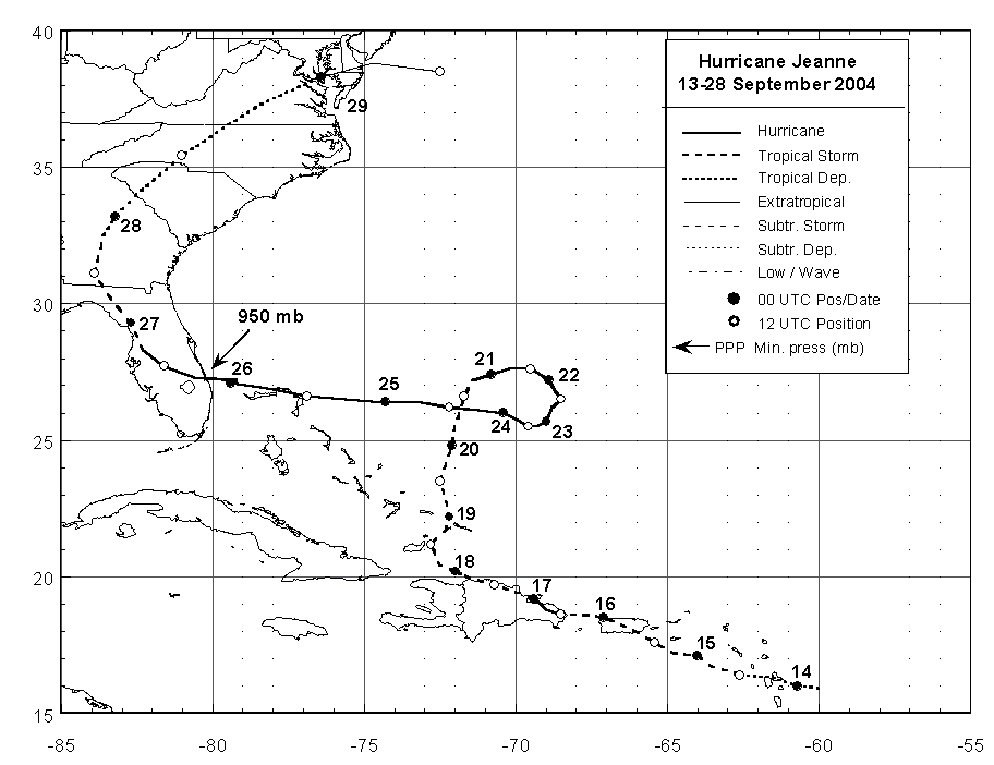
Figure 1:
Best track positions for Hurricane Jeanne,
13-28 September 2004.
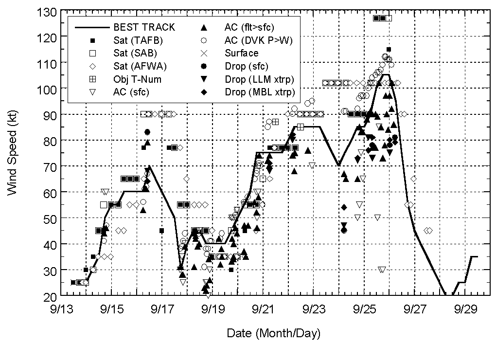
Figure 2:
Selected wind observations and best
track maximum sustained surface wind speed curve for Hurricane
Jeanne, 13-28 September 2004. Aircraft observations have been
adjusted for elevation using 90%, 80%, and 80% reduction factors
for observations from 700 mb, 850 mb, and 1500 ft, respectively.
Dropwindsonde observations include actual 10 m winds, as well as
surface estimates derived from the mean wind over the lowest 150 m
of the wind sounding (LLM), and from the sounding boundary layer
mean (MBL). Objective Dvorak estimates represent linear averages
over a three-hour period centered on the nominal observation
time.
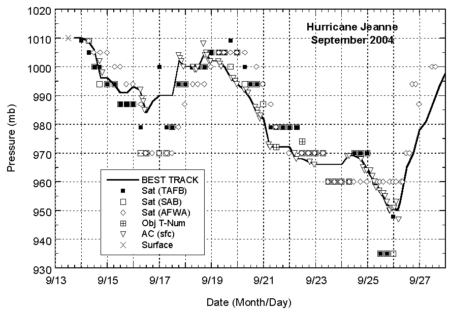
Figure 3:
Selected pressure observations
and best track minimum central pressure curve for Hurricane Jeanne,
13-28 September 2004.
|


