
Field Project: CASES-99
Principal Investigators: Robert Banta and Rob Newsom
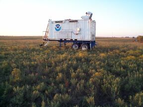
HRDL at the CASES-99 field site outside Leon, Kansas The Cooperative Atmosphere and Surface Exchange Study (CASES-99) field observation program was designed to investigate events in the nighttime stable boundary layer (SBL), and to study physical processes associated with the morning and evening transition periods. The overall effort encompassed observation, data analysis, and numerical modeling to achieve an understanding of episodic events that populate the SBL. The SBL, or the atmospheric boundary layer that forms over a cold surface, occurs at night over land. It thus occupies about half of the diurnal cycle, yet transport, fluxes, and other processes in the SBL are poorly understood and often assumed to be negligible.
The Cooperative Institute for Research in the Atmosphere (CIRA) at Colorado State University (CSU) in cooperation with the Environmental Technology Laboratory/NOAA (ETL/NOAA) deployed ETL's High Resolution Doppler Lidar (HRDL) to the CASES-99 field site near Leon, Kansas. The experimental period was October 1-31, 1999. During this time, HRDL recorded approximately 200 hours of data during 23 days of operation, including 12 intensive operation periods (IOPs). Funding for the deployment and follow-on data analysis was provided by the Army Research Office, the Center for Geosciences/Atmospheric Research (CG/AR) at Colorado State University, and the National Science Foundation (NSF) (Grant # ATM-9908453).
The objectives of the HRDL deployment were:
- To use the analysis of HRDL data in coordination with other measurements, including surface-flux stations, boundary-layer profilers, radars, high-resolution radiosondes, tethered balloons and kites, to understand the roles of
in modulating or controlling transport and fluxes near the surface under stable conditions.
- gravity waves
- turbulence structures
- low-level jets
- local drainage currents
- To obtain 3-D lidar datasets to evaluate the potential of four-dimensional variational data assimilation (4DVAR) techniques for single-Doppler wind retrieval, LES initialization, and fundamental boundary-layer research.
The extensive array of in-situ and remote sensing instruments, including HRDL, provided unprecedented spatial and temporal resolution of SBL processes. On going analysis of the CASES-99 dataset will lead to better estimates of heat, momentum, and trace-species fluxes through the boundary layer, and to improved parameterizations of these fluxes in numerical models.
CASES-99 HRDL datasets
Raw radial velocity and intensity data acquired by HRDL during the CASES-99 IOPs are available through the Joint Office for Science Support (JOSS) site. These data are stored in netCDF, and have been subjected to minimal quality control.
Vertical profiles of mean horizontal winds have been computed from the HRDL dataset. These data are stored in ASCII format, and are available by clicking here. Click here to see a photo gallery of CASES-99 HRDL pictures.
To view selected samples of data, click on the desired day in the calendar below. Please note, all dates and times are given in Universal Coordinated Time (UTC). To convert UTC to central daylight time, subtract five (5) hours.
October 1999
S M T W R F S 1 2 3 4 5 6 7 8 9 10 11 12 13 14 15 16 17 18 19 20 21 22 23 24 25 26 27 28 29 30 31
Related publications:
- Banta, R. M., L. S. Darby, R. K. Newsom, R. M. Hardesty, J. N. Howell, 2000: Atmospheric Gravity Waves, Low-Level Jets, and Mountain Gap Flows Measured by ETL's Doppler Lidars during October 1999. 20th International Laser Radar Conference, Vichy, France, 10-14 July.
- Banta, R. M., R. K. Newsom, J. K. Lundquist, Y. L. Pichugina, R. L. Coulter, and L. D. Mahrt, 2001: Nocturnal Low Level Jet Characteristics observed during CASES-99 Boundary-Layer Meteor, in press.
- Banta, R. M., R. K. Newsom, Y. L. Pichugina, and J. K. Lundquist, 2001: Low-level dynamics and parameterization of surface fluxes in the stable boundary layer. Ninth Conference on Mesoscale Processes, Fort Lauderdale, Florida, 30 July - 2 August.
- Blumen, W., R. M. Banta, S. P. Burns, D. C. Fritts, R. K. Newsom , G. S. Poulos, J. Sun, 2001: Turbulence statistics of a Kelvin-Helmholtz billow event observed in the nighttime boundary layer during the CASES-99 field program. Dynamics of Atmospheres and Oceans, 34, 189-204.
- Newsom, R. K. and R. M. Banta, 2002: Shear-Flow Instability in the Stable Nocturnal Boundary Layer as Observed by Doppler Lidar during CASES-99. Journal of the Atmospheric Sciences, in press.
- Newsom, R. K, R. M. Banta, J. K. Lundquist, 2000: Low-level jet characteristics as determined by high-resolution Doppler lidar during CASES-99. American Geophysical Union Fall Meeting, San Francisco, CA, 14-19 December.
- Newsom, R. K, R. M. Banta, J. Otten, W. L. Eberhard, J. K. Lundquist, 2000: Doppler lidar observations of internal gravity waves, shear instability and turbulence during CASES-99. 14th Symposium on Boundary Layers and Turbulence, Aspen, Colorado, 7-11 August. Amer. Meteor. Soc., Boston.
- Newsom, R. K., W. A. Brewer, R. M. Hardesty, and V. Wulfmeyer, 2001. Development and meteorological applications of the NOAA/NCAR high-power 2mm Doppler lidar. Optical Remote Sensing of the Atmosphere, OSA Technical Digest (Optical Society of America, Washington DC), pp. 102-104.
- Poulos, G.S., W. Blumen, D. C. Fritts, J. K. Lundquist, J. Sun, S. P. Burns, C. Nappo, R. M. Banta, R. K. Newsom, J. Cuxart, E. Terradellas, B. Balsley, M. L. Jensen, 2001: CASES-99: A Comprehensive Investigation of the Stable Nocturnal Boundary Layer. Bull. Amer. Meteorol. Soc., submitted.
- Sun, J., D. H. Lenschow, S. P. Burns, R. M. Banta, R. K. Newsom, R. L. Coulter, S. Frasier, T. Ince, C. Nappo, B. B. Balsley, M. L. Jensen, D. Miller, B. Skelly, J. Cuxart, W. Blumen, X. Lee, and X. Z. Hu, 2001: Intermittent turbulence in stable boundary layers and its relationship with density currents. Boundary-Layer Meteor., submitted.
- Worthington, R.M., R. M. Banta, R. K. Newsom, J. K. Lundquist, M. L. Jensen, A. Muschinski, R. G. Frehlich, B. B. Balsley, 2000: Combined lidar and in-situ measurements of waves in the stable night-time boundary layer above Kansas. 14th Symposium on Boundary Layers and Turbulence, Aspen, Colorado, 7-11 August. Amer. Meteor. Soc., Boston.
HRDL LidarLast updated: April 5, 2002
CASES-99 Home Page
CASES-99 Field Catalog
CASES-99 Project Abstract
CIRA Home Page
Center for Geosciences/Atmospheric Research (CG/AR)
Comments? Questions? Suggestions? E-mail at (Yelena.Pichugina@noaa.gov).
