|
|
|
QuikSCAT Data

Arctic Replenished
April 3 |

Two Java Sea Disasters |

SeaWinds on QuikSCAT |

QuikSCAT Launch from Vandenberg Air Force Base
(June 19, 1999) |
Wind-Ice Interaction
(July 21, 1999) |

Greenland
(July 1999) |

Ocean Surface Winds in the Atlantic and Pacific Oceans
(Aug. 1, 1999) |

SeaWinds Clocks Hurricane Dora's Wind Speeds
(Aug. 10, 1999) |

SeaWinds Watches for Breakup of Giant Iceberg
(Sept. 9, 1999) |

Global Coverage with Detail of Hurricane Floyd
(Sept. 13, 1999) |

South Georgia Island/South Atlantic Ocean
(Sept. 13, 1999) |

Super Typhoon Bilis Hurls Rain and Wind
(Aug. 23, 2000) |

Super Typhoon Bilis Hurls Rain and Wind
(Aug. 23, 2000) |

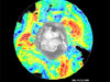
Image of Antarctica from a single day's data
(Oct. 2, 2000) |

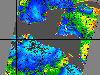
Image of Icebergs B15 & B16 off the Ross Ice Shelf
(Oct. 2, 2000) |

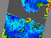
Image of Icebergs A43A & B and A44 off the Ronne Ice Shelf in the Weddell Sea
(Oct. 2, 2000) |

Catalina Eddy Captured by QuikSCAT |

QuikSCAT image of winds on the surface of the Pacific Ocean
January 8, 2004 |
Three Candles for QuikScat |

QuikScat images of Larsen Ice Shelf |

Latest Ocean Winds Research Creates a Stir |

Quikscat satellite image shows strong winds along the Southern California coast |

Image showing sea surface temperature, Feb. 10, 2002 |

Image indicates level of chlorophyll off California |
Gulf of Tehuantepec |
Gulf of Tehuantepec |

Gulf of Tehuantepec |

Typhoon Nesat, June 6, 2005 |

South America's Water Cycle
July 5, 2006 |

Vast Regions of West Antarctica Melted in Recent Past |

Hurricane Dean
August 16, 2007 |

Super Typhoon Sepat
August 17, 2007 |

New Atlases Use NASA Data to Chart Ocean Winds
April 17, 2008 |

Ocean Wind Power Maps Reveal Possible Wind Energy Sources
July 9, 2008 |

Hurricane Dolly
July 23, 2008 |
|
