Arctic Change NOAA
A near-realtime Arctic Change Indicator website

HOME
NEWS
OVERVIEW
TABLE OF INDICATORS
CLIMATE
Arctic Oscillation
Surface Temps
Stratospheric Temps
Clouds
Ocean
GLOBAL
City Temps
Ocean Overturning
LAND
Roads
Permafrost
Tundra
Rivers
Waterfowl
Caribou
MARINE ECOSYSTEM
Overview
Bering Sea
Barents Sea
Greenland
ICE
Sea Ice
North Pole
Glaciers
Snow Cover
HUMAN
Shishmaref
Marine Access
Canadian Marine
Roads

Ice - Snow Cover

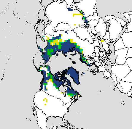
Sea Ice | North Pole Observations | Glaciers | Snow Cover

The Arctic is generally snow covered in winter, so variations in snow cover extent actually occurs in the sub-Arctic more than in the Arctic. Snow cover area in Eurasia decreased in the early 1990s and during a cold event in 2003, but generally the observational record (based on satellite data) shows large year-to-year variability. Snow cover area in North America decreased from the late 1980s onward, again with much year-to-year variability. The twenty-four year trend in mean annual hemispheric snow extent indicates a decrease of approximately 4% per decade.

Eurasian Snow Cover Anomalies chart North American (except Greenland) Snow Cover Anomalies chart
legend:  winter blue, spring green, summer red, fall orange, 12-month running mean black

Eurasian Snow Cover Anomalies.From the Global Snow Lab at Rutgers University.

North American (except Greenland) Snow Cover Anomalies. From the Global Snow Lab at Rutgers University.

Frequency of snow cover on the land areas
 
Time series of snow melt dates (date when snow disappeared) constructed for the NOAA/CMDL Barrow Observatory. Three linear regressions are plotted; an overall fit for 1941-2004 (thin black line), one for all years prior to 1977 (green), and a third beginning in 1977 (red). Results of an empirical model are also shown (dashed blue line). The time series was compiled from direct snow depth observations, proxy estimates using daily temperature records, and beginning in 1986 on the basis of surface radiometric measurements From R.S.Stone, Updated from Stone et al., 2002.


Frequency of snow cover on the land areas of the Northern Hemisphere during February 2007 (left) and May 2007 (right). The 50% contour (in the green zone, represents the approximate climatological mean position of the snow boundary. [Figure courtesy of David Robinson, Global Snow Lab , Rutgers University Climate Laboratory].