 |
 Technical Information Technical Information |
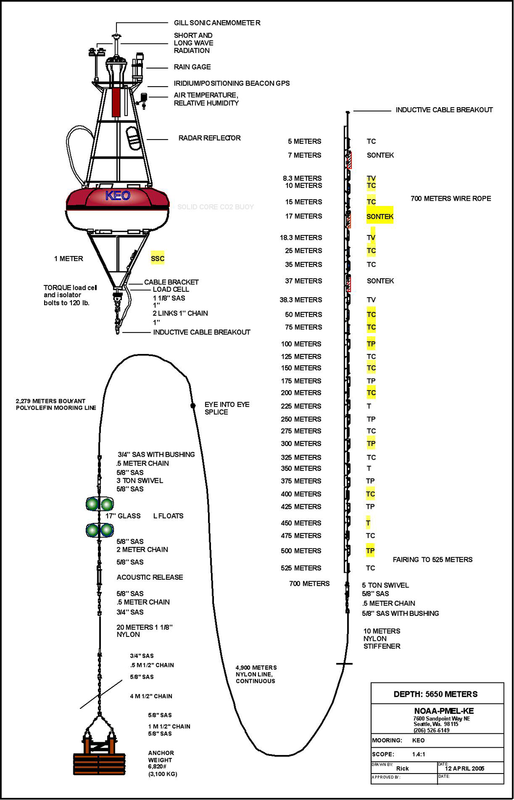
KEO mooring was developed at the Pacific Marine Environmental Laboratory (PMEL) and is essentially a Tropical Atmosphere Ocean (TAO) mooring modified for the harsh conditions of the Kuroshio Extension region. Special features of the KEO mooring that make it more robust include:
- Slack line with scope (mooring line / water depth) of 1.4
- Sonic anemometer
- Modifications to the buoy platform and mooring line for added buoyancy and reduced drag
- Increased anchor weight
As part of the global network of time series reference sites, the KEO project office encourages wide use of the data and welcomes collaborations. In particular,
- All data are freely available
- Daily-averaged and spot measurements are telemetered to shore in near-realtime and made available within one day (see "Data")
- A subset of the surface telemetered measurements are also made available in near-realtime through the GTS beginning Sept 2007
- High resolution data are available in delay mode within 6 months of sensor recovery
- KEO carries an extensive suite of surface and subsurface sensors to monitor air-sea heat, moisture, and momentum fluxes; and surface and subsurface temperature and salinity. Beginning June 2005, KEO will also monitor ocean currents and air-sea CO2 flux.
Details on the KEO mooring design, sensor suite, sampling specifications, and telemetry can be found in the related links
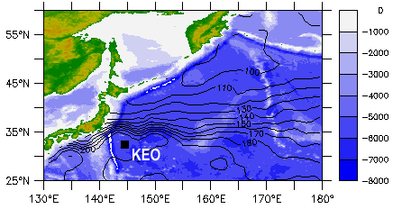 Fig 1. Sea floor bathymetry from Smith and Sandwell (1997) are indicated by shades of blue. Mean sea level height from Teague et al. (1990) are indicated by contours.
|
|
Mooring |
Region |
Latitude |
Longitude |
Deployment date |
Recovery date |
Water depth (m) |
|
KE Recirculation Gyre |
32° 21.0'N |
144° 38.2'E |
16 June, 2004 |
28 May, 2005 (top 700 m) |
5685 |
|
KE Recirculation Gyre |
32° 21.0'N |
144° 38.2'E |
28 May, 2005
(top 700m)
|
10 Nov, 2005
|
5685 |
|
KE Recirculation Gyre |
32° 21.0'N |
144° 38.2'E |
5 June, 2006 |
6 May, 2007
(surface instruments) |
5708 |
|
KE Recirculation Gyre |
32° 21.0'N |
144° 38.2'E |
26 Sept, 2007 |
|
5681 |
References:
Milburn, H.B., P.D. McLain, and C. Meinig, 1996: ATLAS Buoy—Reengineered for the next decade. Proceedings of IEEE / MTS Oceans '96 , 698–702.
Smith, W. H. F., and D. T. Sandwell, 1997: Global seafloor topography from satellite altimetry and ship depth soundings. Science,
277, 1957-1962.
Teague, W. J., M. J. Carron, and P. J. Hogan, 1990: A comparison between the Generalized Digital Environmental Model and Levitus climatologies. J. Geophys. Res., 95, 7167-7183.
|
|


