
M4.2 - 8km ENE of Luther, Oklahoma (BETA) 2013-04-16 10:16:53 UTC
 Google Earth KML
Summary
Location and Magnitude contributed by: USGS National Earthquake Information Center
General
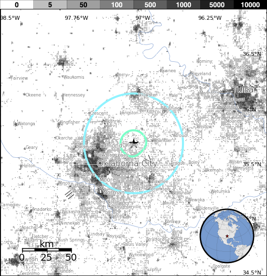
ShakeMap
Contributed by USGS National Earthquake Information Center
Instrumental Intensity
PGA (%g)
PGV (cm/s)
Uncertainty
Station List
PAGER
Impact Estimates
Estimated Fatalities
Histogram of Estimated FatalitiesEstimated Economic Losses
Histogram of Estimated Economic LossesCity Exposure List
See PAGER XML link (above).
Did You Feel It? Tell Us!
Contributed by USGS National Earthquake Information Center
Tell Us!
Did you feel this earthquake? Tell Us!
Intensity Maps
Graphs
Responses
Scientific
Location and Magnitude contributed by: USGS National Earthquake Information Center
Summary
Preferred Location Parameters
| Parameter | Value | Uncertainty |
|---|---|---|
| Magnitude | 4.2 Mw | Not Specified |
| Location | 35.687°N, 97.109°W | ± 10.2 km |
| Depth | 5.0 km | ± 2.0 km |
| Number of Stations Used | 27 | |
| Number of Phases Used | 27 | |
| Minimum Distance | 16.7 km (0.15°) | |
| Travel Time Residual | 0.47 sec | |
| Azimuthal Gap | 68° | |
| Review Status | MANUAL | |
| Event ID | usb000g7we |
Scientific and Technical Links
Moment Tensor
Moment Tensor EQXMLContributed Solutions
Moment Tensor
P-Wave Travel Times
Downloads
All Downloads
| Product | Title | Links | ID |
|---|---|---|---|
| cap (Preferred) (US) | CAP Alert | usb000g7we | |
| dyfi (Preferred) (US) | DYFI City Map | usb000g7we | |
| dyfi (Preferred) (US) | DYFI Geocoded Map | usb000g7we | |
| dyfi (Preferred) (US) | Intensity vs. Distance Plot | usb000g7we | |
| dyfi (Preferred) (US) | Responses vs. Time Plot | usb000g7we | |
| dyfi (Preferred) (US) | Intensity Summary | usb000g7we | |
| dyfi (Preferred) (US) | Intensity Summary (Geocoded) | usb000g7we | |
| dyfi (Preferred) (US) | DYFI Combined Geospatial Data | usb000g7we | |
| losspager (Preferred) (US) | Exposure Map | usb000g7we | |
| losspager (Preferred) (US) | onePAGER summary | usb000g7we | |
| losspager (Preferred) (US) | PAGER XML results | usb000g7we | |
| losspager (Preferred) (US) | PAGER Exposure KML | usb000g7we | |
| moment-tensor (Preferred) (US) | Earthquake XML (EQXML) | usb000g7we | |
| origin (Preferred) (US) | Earthquake XML (EQXML) | usb000g7we | |
| p-wave-travel-times (Preferred) (US) | Theoretical P-Wave Travel Times Map for the World | usb000g7we | |
| p-wave-travel-times (Preferred) (US) | Theoretical P-Wave Travel Times Map for the United States | usb000g7we | |
| p-wave-travel-times (Preferred) (US) | Theoretical P-Wave Travel Times Table | usb000g7we | |
| phase-data (Preferred) (US) | Earthquake XML (EQXML) | usb000g7we | |
| shakemap (Preferred) (US) | XML Grids | usb000g7we | |
| shakemap (Preferred) (US) | Rock Grid | usb000g7we | |
| shakemap (Preferred) (US) | Uncertainty Grid | usb000g7we | |
| shakemap (Preferred) (US) | Text Grids | usb000g7we | |
| shakemap (Preferred) (US) | GIS Files | usb000g7we | |
| shakemap (Preferred) (US) | ESRI Raster Files | usb000g7we | |
| shakemap (Preferred) (US) | Station Lists | usb000g7we | |
| shakemap (Preferred) (US) | Metadata | usb000g7we | |
| shakemap (Preferred) (US) | Supplemental Information | usb000g7we | |
| shakemap (Preferred) (US) | TV Info Sheet | usb000g7we | |
| shakemap (Preferred) (US) | Intensity Thumbnail | usb000g7we | |
| shakemap (Preferred) (US) | Intensity Map | usb000g7we | |
| shakemap (Preferred) (US) | PGA Map | usb000g7we | |
| shakemap (Preferred) (US) | PGV Map | usb000g7we | |
| shakemap (Preferred) (US) | TV Map | usb000g7we | |
| shakemap (Preferred) (US) | Bare TV Map | usb000g7we | |
| shakemap (Preferred) (US) | Uncertainty Map | usb000g7we | |
| shakemap (Preferred) (US) | Intensity Contours | usb000g7we | |
| shakemap (Preferred) (US) | PGA Contours | usb000g7we | |
| shakemap (Preferred) (US) | PGV Contours | usb000g7we |
The use of EQXML formatted data is temporary. This data will be changing to QuakeML v1.2RC3 format.
