
Unified Interior Regions
Region 2: South Atlantic-Gulf (Includes Puerto Rico and the U.S. Virgin Islands)
Regions L2 Landing Page Tabs
We conduct impartial, multi- and interdisciplinary research and monitoring to address a broad range of natural-resource issues that affect the quality of life of citizens and landscapes in the Southeastern United States and the Caribbean region.
News

USGS Deploying Storm Tide Sensors Along Gulf Coast for Hurricane Delta
To learn more about USGS’s role in providing science to decision-makers before, during and after Hurricane Delta, visit the USGS Hurricane Delta page at www.usgs.gov/delta.

Bridging the Language Barrier During the Puerto Rico Earthquake
What happens when a 6.4 magnitude earthquake strikes Puerto Rico and the public needs critical information? How does a mostly English-speaking science agency reach a mostly Spanish-speaking public?

Earth MRI Funds Critical Minerals Projects in Texas
A total of $134,453 will fund new research and preserve important data across the Lone Star State
Publications

Development and application of surrogate models, calculated loads, and aquatic export of carbon based on specific conductance, Big Cypress National Preserve, south Florida, 2015–17
Understanding the carbon transport within aquatic environments is crucial to quantifying global and local carbon budgets, yet limited empirical data currently (2021) exist. This report documents methodology and provides data for quantifying the aquatic export of carbon from a cypress swamp within Big Cypress National Preserve and is part of a...
Booth, Amanda
Red imported fire ants reduce invertebrate abundance, richness, and diversity in Gopher Tortoise burrows
Gopher Tortoise (Gopherus polyphemus) burrows support diverse commensal invertebrate communities that may be of special conservation interest. We investigated the impact of red imported fire ants (Solenopsis invicta) on the invertebrate burrow community at 10 study sites in southern Mississippi, sampling burrows (1998–2000) before and after bait...
Epperson, Deborah Mardeane; Allen, Craig R.; Hogan, Katharine F.E. The impact of ventilation patterns on calcite dissolution rates within karst conduits
Erosion rates in streams vary dramatically over time, as differences in streamflow and sediment load enhance or inhibit erosion processes. Within cave streams, and other bedrock channels incising soluble rocks, changes in water chemistry are an important factor in determining how erosion rates will vary in both time and space. Prior studies in...
Covington, Matthew D.; Knierim, Katherine J.; Young, Holly H; Rodriguez, Josue; Gnoza, Hannah
Coastal Change Hazards
Natural processes such as waves, tides, and weather, continually change coastal landscapes. The integrity of coastal homes, businesses, and infrastructure can be threatened by hazards associated with event-driven changes, such as extreme storms and their impacts on beach and dune erosion, or longer-term, cumulative...

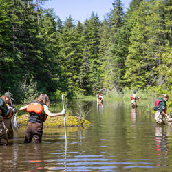
Fish Chat and Slam November 2019
Fifty fish biologists from 15 organizations participated in a three-day Fish Chat and Slam event in South Florida on November 5-7, 2019.

Contaminants Assessment in the Coral Reefs of the Virgin Islands National Park and Virgin Islands Coral Reef National Monument
USGS collected samples at reef locations within the Virgin Islands National Park and analyzed for the presence of contaminants, organotin compounds, or sunscreen compounds.
")
Fine-Scale Dive Profiles and Activity Patterns of Sea Turtles in the Gulf of Mexico
Researchers are developing acceleration data logger pop-off packages that can be affixed to sea turtles to collect behavioral patterns of diving, surfacing, and general activity levels.

Applications of Advanced Tracking and Modeling Tools with Burmese Pythons across South Florida's Landscape
Researchers will determine movement rates and habitat-use patterns of pythons across the South Florida landscape by conducting a telemetry study tracking pythons simultaneously in several locations
Habitat Selection of the Burmese Python in the Florida Everglades
Researchers plotted locations of radio-tagged pythons to create a habitat suitability model.

Hotspot and Risk Analysis for Sea Turtles in the Florida Keys National Marine Sanctuary
Researchers will collect location data that will be used to identify areas of high-use for resident sea turtles in the Florida Keys National Marine Sanctuary.
 - Black (TM)")
U.S. Seismic Hazard Maps – Puerto Rico and the U.S. Virgin Islands, Samoa and the Pacific Islands, and Guam and Northern Mariana Islands
Seismic hazard maps for Puerto Rico and the U.S. Virgin Islands, Samoa and the Pacific Islands, and Guam.
")
Spatial Ecology of Bobcats in the Greater Everglades
WARC researchers will estimate the density and distribution of bobcats in relation to environmental variables through the development of spatially explicit capture-recapture and occupancy models.

Topobathymetric Elevation Model of Outer Banks and Pamlico Sound, North Carolina
Pamlico Sound is ecologically important as it is the second largest estuary in the United States, and is the largest lagoon on the U.S. east coast. The sound is separated from the Atlantic Ocean by the Outer Banks, a series of low, sandy barrier islands that are vulnerable to hurricane storm surge and sea-level rise. The seamless high-resolution topobathymetric digital elevation model (TBDEM)...

Topobathymetric Elevation Model of Mobile Bay, Alabama
Mobile Bay is ecologically important as it is the fourth largest estuary in the United States. The Mobile Bay topobathymetric digital elevation model (TBDEM) was developed in collaboration between U.S. Geological Survey (USGS) Coastal and Marine Geology Program (CMGP) and USGS National...

Hurricane Dorian - Forecast and Documentation of Coastal Change
Hurricane Dorian coastal change forecast and pre- and post-storm photos documenting coastal change.

Suspended-sediment concentration data from water samples collected in 2016-17 in Grand Bay, Alabama and Mississippi
In wetlands within and near Grand Bay National Estuarine Research Reserve, parts of the salt marsh are eroding relatively rapidly. To understand the connection between sediment fluxes and these processes, the U.S. Geological Survey made oceanographic and water-quality measurements from August 2, 2016, to January 28, 2017
Crustal Architecture Beneath the Southern Midcontinent (USA) -- Data Grids and 3D Geophysical Models
Regional grid files and 3D voxel models were used to study crustal architecture beneath the Southern Midcontinent (USA) by McCafferty and others (2019). The study covered a rectangular, multi-state area of 924 by 924 kilometers centered on Missouri, and a corresponding volume extending from the topographic surface to a depth of 50 kilometers below sea level. The grid files consist of
Ground-based time-domain electromagnetic data and resistivity models for the Mississippi Alluvial Plain Project
The Mississippi Alluvial Plain (MAP) Project contains several geologic units which act as important aquifers. We collected several sets of time-domain electromagnetic (TEM) data consisting of two higher-density surveys and six regional-scale transects. The higher density surveys were collected to compare and contrast to other geophysical data not included in this data release, such as a

Coastal and Marine Geoscience Data System
Information about scientific data collected through field activities conducted by scientists in the USGS Coastal and Marine Hazards and Resources program

National Water Information System (NWIS) Mapper
The NWIS mapper provides access to over 1.5 million sites contained in the USGS National Water Information System (NWIS), including sites where current and historical surface-water, groundwater, springs, and atmospheric data has been collected. Users can search by site type, data type, site number, or place.

Hydrologic Conditions of Selected Reservoirs in Puerto Rico
The following graphs show water surface elevations above NGVD 1929 in selected reservoirs for several years, including 2015. The purpose of these graphs is to compare water surface elevations during 2015 with water surface elevations observed during years when documented droughts have occurred.

Water Level and Salinity Analysis Mapper
The Water Level and Salinity Analysis Mapper is designed to conduct automated statistical and graphical analyses on water-level and salinity data collected from sites monitored by the U.S. Geological Survey (USGS) in South Florida.
Projected flood extent polygons and flood depth points based on 10-, 50-, 100-, and 500-year wave-energy return periods, with and without coral reefs, for the Territory of the U.S. Virgin Islands (the islands of Saint Croix, Saint John, and Saint Thomas)
This part of the data release presents projected flooding extent polygon (flood masks) and flooding depth points (flood points) shapefiles based on wave-driven total water levels for the Territory of the U.S. Virgin Islands (the islands of Saint Croix, Saint John, and Saint Thomas). For each island there are 8 associated flood mask and flood depth shapefiles: one for each four n
Time series data of oceanographic conditions from La Parguera, Puerto Rico, 2017-2018 Coral Reef Circulation and Sediment Dynamics Experiment
Time-series data of water surface elevation, waves, currents, temperature, and salinity collected between 17 May 2017 and 17 Jan 2018 off the southwest coast of Puerto Rico in support of a study on circulation and sediment transport dynamics over coral reefs. The data are available in NetCDF format, grouped together in zip files by instrument site location. A README.txt file details the

Projected flooding extents and depths based on 10-, 50-, 100-, and 500-year wave-energy return periods, with and without coral reefs, for the States of Hawaii and Florida, the Territories of Guam, American Samoa, Puerto Rico, and the U.S. Virgin Islands,
This data release provides flooding extent polygons (flood masks) and depth values (flood points) based on wave-driven total water levels for 22 locations within the States of Hawaii and Florida, the Territories of Guam, American Samoa, Puerto Rico, and the U.S. Virgin Islands, and the Commonwealth of the Northern Mariana Islands. For each of the 22 locations there are eight ass
Projected flood extent polygons and flood depth points based on 10-, 50-, 100-, and 500-year wave-energy return periods, with and without coral reefs, for the State of Hawaii (the islands of Hawaii, Kahoolawe, Kauai, Lanai, Maui, Molokai, Niihau, and Oahu
This part of the data release presents projected flooding extent polygon (flood masks) and flooding depth points (flood points) shapefiles based on wave-driven total water levels for the State of Hawaii (the islands of Hawaii, Kahoolawe, Kauai, Lanai, Maui, Molokai, Niihau, and Oahu). For each island there are 8 associated flood mask and flood depth shapefiles: one for

The USGS developed the SPARROW (SPAtially Referenced Regressions On Watershed attributes) modeling framework to relate water-quality monitoring data to upstream nutrient and sediment sources and watershed characteristics. The mapper can be used to evaluate alternative hypotheses about the relative importance of various pollutant sources.

This map shows the provinces assessed by the USGS for undiscovered oil and gas resources.

Okeechobee County, Florida irrigated agricultural land-use GIS shapefile for the 2017 growing season
This data set consists of a detailed digital map of individual irrigated fields and a summary of the irrigated acreage for the 2017 growing season developed for Okeechobee County, Florida. Selected attribute data that include crop type, irrigation system, and primary water source were collected for each irrigated field.
Flynn Creek crater is a 3.8 km diameter, 360-million-year-old impact structure located in north central Tennessee, and is an invaluable terrestrial analog for the study of impact cratering dynamics. The Flynn Creek Crater Sample Collection consists of over two thousand boxes of drill core from 18 drill holes in the crater’s central uplift, floor, and rim.

Hurricane Irma, the most intense hurricane observed in the Atlantic in the last decade, approached the west coast of Florida on September 10th, 2017. This animation shows the precipitation and river conditions through time as Irma moved over the southeastern United States.

The New Hope arm of Jordan Lake, located in Chatham County, North Carolina, serves as a drinking-water supply for the Towns of Cary, Apex, and Morrisville. The reservoir is listed as impaired due to nutrient over-enrichment and occasionally experiences algal blooms and fish kills.

Real-Time streamflow data for the Lower Roanoke

Development of a Guidance Manual for Assessing Scour Using the South Carolina Bridge-Scour Envelope Curves
Figure 1. Location of physiographic provinces and bridge-scour investigation sites in South Carolina.

All data collected during this project will be available online in the USGS National Water Information System (NWIS).

All data collected and analyzed by the USGS will be archived in the USGS National Water Information System (NWIS) database

Georgia Augusta Richmond County Groundwater Level Network

The USGS and EPA project will be conducted at the North Carolina State University (NCSU) Lake Wheeler Road Field Laboratory (LWRFL) in Wake County, North Carolina. The LWRFL is an agricultural site used for both research and teaching purposes. The farm contains both a swine facility and a dairy facility with each having two animal-waste storage lagoons.
Development and application of surrogate models, calculated loads, and aquatic export of carbon based on specific conductance, Big Cypress National Preserve, south Florida, 2015–17
Understanding the carbon transport within aquatic environments is crucial to quantifying global and local carbon budgets, yet limited empirical data currently (2021) exist. This report documents methodology and provides data for quantifying the aquatic export of carbon from a cypress swamp within Big Cypress National Preserve and is part of a...
Booth, Amanda Red imported fire ants reduce invertebrate abundance, richness, and diversity in Gopher Tortoise burrows
Gopher Tortoise (Gopherus polyphemus) burrows support diverse commensal invertebrate communities that may be of special conservation interest. We investigated the impact of red imported fire ants (Solenopsis invicta) on the invertebrate burrow community at 10 study sites in southern Mississippi, sampling burrows (1998–2000) before and after bait...
Epperson, Deborah Mardeane; Allen, Craig R.; Hogan, Katharine F.E. The impact of ventilation patterns on calcite dissolution rates within karst conduits
Erosion rates in streams vary dramatically over time, as differences in streamflow and sediment load enhance or inhibit erosion processes. Within cave streams, and other bedrock channels incising soluble rocks, changes in water chemistry are an important factor in determining how erosion rates will vary in both time and space. Prior studies in...
Covington, Matthew D.; Knierim, Katherine J.; Young, Holly H; Rodriguez, Josue; Gnoza, Hannah
Underwater photographic reconnaissance and habitat data collection in the Florida Keys—A procedure for ground truthing remotely sensed bathymetric data
Bathymetric geoprocessing analyses of the Florida Reef Tract have provided insights into trends of seafloor accretion and seafloor erosion over time and following major storm events. However, bathymetric surveys sometimes capture manmade structures and vegetation, which do not represent the desired bare-earth data. Therefore, ground truthing is...
Fehr, Zachery W.; Yates, Kimberly K. Effects-based monitoring of bioactive chemicals discharged to the Colorado River before and after a municipal wastewater treatment plant replacement
Monitoring of the Colorado River near the Moab, Utah, wastewater treatment plant (WWTP) outflow has detected pharmaceuticals, hormones, and estrogen-receptor (ER)-, glucocorticoid receptor (GR)-, and peroxisome proliferator-activated receptor-gamma (PPARγ)-mediated biological activities. The aim of the present multi-year study was to assess...
Cavallin, J.E.; Battaglin, William A.; Beihoffer, Jon; Blackwell, Bradley D.; Bradley, Paul; Cole, AR; Ekman, Drew R.; Hofer, R; Kinsey, J; Keteles, Kristen; Weissinger, R; Winkelman, Dana L.; Villeneuve, Daniel L.
Water resources of Red River Parish, Louisiana
Information concerning the availability, use, and quality of water in Red River Parish, Louisiana, is critical for proper water-supply management. The purpose of this fact sheet is to present information that can be used by water managers, parish residents, and others for stewardship of this vital resource. In 2014, about 5.76 million gallons per...
Robinson, Angela L.; White, Vincent E.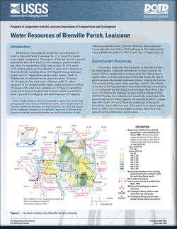
Water resources of Bienville Parish, Louisiana
Information concerning the availability, use, and quality of water in Bienville Parish, Louisiana, is critical for proper water-supply management. The purpose of this fact sheet is to present information that can be used by water managers, parish residents, and others for stewardship of this vital resource. In 2014, about 13.03 million gallons per...
Robinson, Angela L.; White, Vincent E. Reestablishing a stepping-stone population of the threatened elkhorn coral Acropora palmata to aid regional recovery
Recovery of the elkhorn coral Acropora palmata is critical to reversing coral reef ecosystem collapse in the western Atlantic, but the species is severely threatened. To gauge potential for the species’ restoration in Florida, USA, we conducted an assisted migration experiment where 50 coral fragments of 5 nursery-raised genetic strains...
Kuffner, Ilsa B.; Stathakopoulos, Anastasios; Toth, Lauren T.; Bartlett, Lucy
Continuous stream discharge, salinity, and associated data collected in the lower St. Johns River and its tributaries, Florida, 2019
The U.S. Army Corps of Engineers, Jacksonville District, is deepening the St. Johns River channel in Jacksonville, Florida, from 40 to 47 feet along 13 miles of the river channel beginning at the mouth of the river at the Atlantic Ocean, in order to accommodate larger, fully loaded cargo vessels. The U.S. Geological Survey, in cooperation with the...
Ryan, Patrick J.
Mapping Phragmites australis live fractional cover in the lower Mississippi River Delta, Louisiana
In response to a co-occurring non-native scale infestation and Phragmites australis dieback in southeast Louisiana, normalized difference vegetation index (NDVI) satellite mapping was implemented to track P. australis condition in the lower Mississippi River Delta. While the NDVI mapping successfully documented relative condition changes,...
Rangoonwala, Amina; Howard, Rebecca J.; Ramsey III, Elijah W.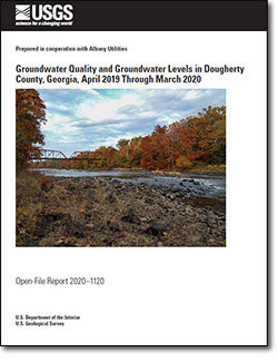
Groundwater quality and groundwater levels in Dougherty County, Georgia, April 2019 through March 2020
The Upper Floridan aquifer is the uppermost, reliable aquifer in southwest Georgia. The aquifer lies on top of the Claiborne, Clayton, and Cretaceous aquifers, all of which exhibited water level declines in the 1960s and 1970s. The U.S. Geological Survey has been working cooperatively with Albany Utilities to monitor groundwater quality and...
Gordon, Debbie W.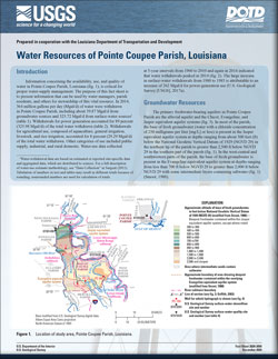
Water resources of Pointe Coupee Parish, Louisiana
Information concerning the availability, use, and quality of water in Pointe Coupee Parish, Louisiana, is critical for proper water-supply management. The purpose of this fact sheet is to present information that can be used by water managers, parish residents, and others for stewardship of this vital resource. In 2014, 364 million gallons per day...
White, Vincent E.")
The Floodplain and Evaluation Tool (FACET) is an open-source python tool that maps the floodplain extent and derives reach-scale summaries of stream and floodplain geomorphic measurements from high-resolution digital elevation models (DEMs).

The Pedestrian Evacuation Analyst is an ArcGIS extension that estimates how long it would take for someone to travel on foot out of a hazardous area that was threatened by a sudden event such as a tsunami, flash flood, or volcanic lahar. It takes into account the elevation changes and the different types of landcover that a person would encounter along the way.
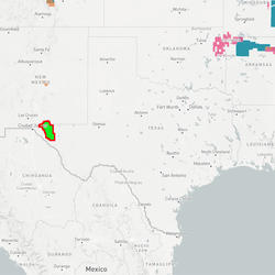
Earth MRI Funds Critical Minerals Projects in Texas
USGS map of Earth MRI projects in Texas' Trans-Pecos region announced in September 2020.

USGS Scientists Work on Four Tropical Cyclones at Once
In this NOAA satellite image from Sept. 15, 2020, Hurricane Sally approaches the U.S. Gulf Coast, Hurricane Paulettte creates storm waves far out in the Atlantic, and Tropical Storms Teddy and Vicky lie near the coast of Africa. Two tropical depressions are also developing; one of them is not visible in this image.

Hurricane Isaias Unlikely to Cause Widespread Atlantic Beach Erosion
USGS coastal change experts predict that storm waves kicked up by the Category 1 hurricane are likely to cause some erosion at the base of the dunes along about 11 percent of coastal beaches between Florida and Virginia. However, only about one percent of beaches in the region are likely to have waves overwashing the dunes, and inundation - the most severe type of beach
...
Dragonfly Mercury Project specimen collection in Glacier NP
Researchers instruct volunteers on how to collect dragonfly larvae in Glacier NP as a part of the Dragonfly Mercury Project.
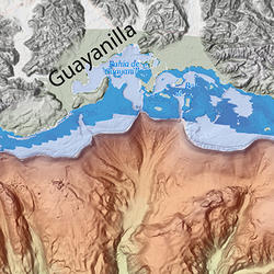
Finding Seafloor Faults Linked to Puerto Rico Earthquake
Map of the portion of the southwest coast of Puerto Rico affected by an earthquake sequence that began in December 2019, along with portions of the seafloor where faults involved in the earthquake sequence were suspected to exist. (A related image shows indications of seafloor faulting found on a USGS seismic research cruise led by USGS research geophysicist Uri ten Brink
...
Scientists find signs of undersea faults off SW Puerto Rico
Locations of multichannel seismic reflection profiles (in black), collected during cruise FA2020-14. The profiles are overlain on colored and shaded multibeam bathymetry, Lidar topography (green and white) and near-shore bathymetry (darker blue), and NOAA coastal relief model (light blue and white). Dashed purple lines – hypothesized faults from the distribution of
...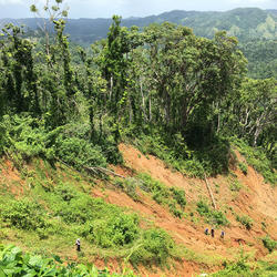
On a hillside in Las Marias, USGS scientists examine landslide effects
USGS ground failure experts examine landslides after Hurricane Maria in the municipality of Las Marias, Puerto Rico.

A helicopter flight reveals landslides' damage in Utuado municipality
An aerial view of landslide damage after Hurricane Maria in Utuado municipality, Puerto Rico.
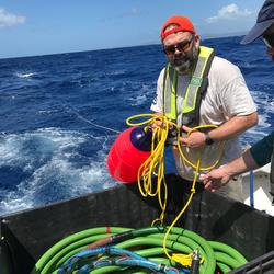
Scientist launches instrument used to map seafloor off Puerto Rico
USGS marine technician Wayne Baldwin prepares to deploy the hydrophone array during a seismic research cruise off the southwest coast of Puerto Rico on board the R/V Sultana in March 2020.

USGS marine technicians launch a hydrophone off Puerto Rico seafloor
USGS marine technicians Alex Nichols (L) and Eric Moore (R) deploy the hydrophone array on a seismic research cruise off the southwest coast of Puerto Rico aboard the R/V Sultana in March 2020.

Three scientists launch a "sparker" used in seafloor mapping
USGS research geologist Jason Chaytor (L) and marine technicians Alex Nichols (center) and Eric Moore (R) deploy the “sparker” sound source on a seismic research cruise off the southwest coast of Puerto Rico aboard the R/V Sultana in March 2020.
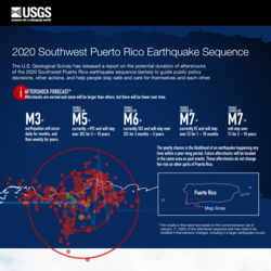
2020 Southwest Puerto Rico Earthquake Sequence (Jan 29, 2020)
The U.S. Geological Survey has released a report on the potential duration of aftershocks of the 2020 Southwest Puerto Rico earthquake sequence (series) to guide public policy decisions, other actions, and help people stay safe and care for themselves and each other.
i) AFTERSHOCK FORECAST*
Aftershocks are normal and some will be larger than others, but there
To learn more about USGS’s role in providing science to decision-makers before, during and after Hurricane Delta, visit the USGS Hurricane Delta page at www.usgs.gov/delta.
What happens when a 6.4 magnitude earthquake strikes Puerto Rico and the public needs critical information? How does a mostly English-speaking science agency reach a mostly Spanish-speaking public?
A total of $134,453 will fund new research and preserve important data across the Lone Star State

The scarcity or overabundance of water presents some of the most dangerous, damaging and costly threats to human life, ecosystems and property in the form of drought, floods and debris flows.

Laura and Sally affecting Gulf Coast, waves from Paulette and Teddy to strike Atlantic beaches
To learn more about USGS’s role in providing science to decision-makers before, during and after Hurricane Sally, visit usgs.gov/sally.

To learn more about USGS’s role in providing science to decision makers before, during and after Hurricane Laura, visit www.usgs.gov/laura

Some erosion likely for nearly one-half of sandy shorelines from East Texas to Alabama
Editor's Note: This updated story reflects today's coastal change forecast and includes a new map.
To learn more about USGS’s role in providing science to decision makers before, during and after Hurricane Laura, visit www.usgs.gov/laura

A magnitude 5.1 earthquake struck near Sparta, North Carolina August 9, 2020 at 8:07 a.m. Eastern Daylight Time. Seismic instruments indicate the earthquake originated at a depth of about 2.3 miles. The USGS currently estimates there is a low likelihood of casualties or damage from this earthquake.

To learn more about USGS’s role in providing science to decision makers before, during, and after Hurricane Isaias, visit the USGS Hurricane Isaias page at https://www.usgs.gov/isaias.

To learn more about USGS’s role in providing science to decision makers before, during, and after Hurricane Isaias, visit the USGS Hurricane Isaias page at https://www.usgs.gov/isaias.

Wave-driven flooding behind dunes unlikely on SE Atlantic coast, USGS predicts
This news release was updated August 3 based on the latest coastal change forecast.
To learn more about USGS’s role providing science to decision makers before, during and after Tropical Storm Isaias, visit https://www.usgs.gov/isaias.
Washington – Today, the U.S. Geological Survey (USGS), U.S. National Park Service (NPS), U.S. Fish and Wildlife Service (FWS) and Conservancy of Southwest Florida announced they have teamed up to radio-track Burmese pythons in Big Cypress National Preserve, Crocodile Lake National Wildlife Refuge and other areas of Southwest Florida.
Follow Region 2 activities on social media, get contact information for Region 2 USGS centers, and meet Region 2's staff and center directors.
Contacts
Locations

Region 2: South Atlantic-Gulf

Wetland and Aquatic Research Center - Gainesville, FL
Phone: 352-378-8181
Fax: 352-378-4956

Lower Mississippi-Gulf Water Science Center - Nashville, TN Office
GS-W-TNnsh Webmaster@usgs.gov
Phone: (615) 837-4700
Fax: (615) 837-4799

Lower Mississippi-Gulf Water Science Center - Montgomery, AL Office
Phone: (334) 395-4131
Fax: (334) 395-4168

Caribbean-Florida Water Science Center - Puerto Rico Office
Phone: (787) 749-7400
Fax: (787) 749-7401

South Atlantic Water Science Center - Raleigh, NC Office
Phone: (919) 571-4000
Fax: (919) 571-4041

South Atlantic Water Science Center - Columbia, SC Office
Phone: (803) 750-6100
Fax: (803) 750-6181

South Atlantic Water Science Center - Norcross, GA Office
Phone: (678) 924-6700
Fax: (678) 924-6710

Caribbean-Florida Water Science Center - Florida Office
Phone: (813) 498-5000
Fax: (813) 498-5002

St. Petersburg Coastal and Marine Science Center
Phone: (727) 502-8000
Fax: (727) 502-8181

Southeast Climate Adaptation Science Center

USGS-St. Petersburg Carbon Analytical Laboratory

South Atlantic Water Science Center - North Carolina: Charlotte Field Office
Phone: (704) 344-6272

South Atlantic Water Science Center - Tifton, GA Field Office
webmaster-ga@usgs.gov
Phone: 229-382-6353

South Atlantic Water Science Center - Charleston, SC Field Office
Phone: 843-460-9724

Lower Mississippi-Gulf Water Science Center - Memphis, TN Office
Phone: 901-678-7287
Fax: 901-678-7300
")
Lower Mississippi-Gulf Water Science Center - Knoxville, TN Office
rbrendli@usgs.gov
Phone: 865-862-2029

Lower Mississippi-Gulf Water Science Center - Tuscaloosa, AL Office
Phone: 205-348-0950

Caribbean-Florida Water Science Center - Fort Myers office
Phone: (239) 275-8448
Fax: (239) 275-6820

Caribbean Florida Water Science Center - Tallahassee Field office
Phone: (850) 553-3640
Fax: (805) 553-3641

Caribbean-Florida Water Science Center - Orlando Office
Phone: (407) 803-5500
Fax: (407) 803-5501

Caribbean-Florida Water Science Center Davie office
Phone: (954) 377-5900
Fax: (954) 377-5901

Wetland and Aquatic Research Center - St. John, USVI

USGS Everglades Research Offices
Phone: 305-242-7834

South Atlantic Water Science Center - North Carolina: Asheville Field Office
Phone: (828) 684-5905

South Atlantic Water Science Center - Georgia: Savannah Field Office
Phone: (843) 784-5005

Northern Rocky Mountain Science Center (NOROCK) Southern Appalachian Duty Station
Phone: 865-974-4790
Fax: 865-974-3555
