
Unified Interior Regions
Region 3: Great Lakes
Great Lakes Restoration Initiative

For more information on the Great Lakes and work being done, check out the Great Lakes Restoration Initiative website here!
GLRIUSGS Science Centers in the Great Lakes Region
For more information on what each center is doing in the Great Lakes, please follow the links below!
Ohio-Kentucky-Indiana Water Science Center
Upper Midwest Water Science Center
Regions L2 Landing Page Tabs
Welcome to Region 3! Our Region includes the states of Minnesota, Wisconsin, Michigan, Indiana, and Ohio. We conduct science to inform resource managers on issues such as aquatic invasive species, water quality and availability, wildlife disease, and restoration of fish/wildlife and their habitats.
News

Media Advisory: Study of Asian Carp Deterrent Begins in January
Reporters: Do you want to interview USGS scientists about the project? Please contact Randy Hines or Marisa Lubeck.

Low-flying Helicopter Will Survey Northeast Wisconsin for Geologic Study
Note to Editors: In the public interest and in accordance with Federal Aviation Administration regulations, the USGS is announcing this low-level airborne project. Your assistance in informing the local communities is appreciated.

Earth MRI Funds Critical Minerals Projects in Indiana
A total of $160,000 will fund new research and preserve important data across the Hoosier State

Invasive Phragmites Science: Management Tools for the Control of Invasive Phragmites to Foster the Restoration of the Great Lakes
The USGS is developing innovative Phragmites control measures to keep this rapidly spreading invasive plant from further expanding its range into new wetland habitats and to aid in the development of successful restoration strategies. Scientists are conducting studies and field tests to determine if fungi that live within the Phragmites are enabling the plant to take over...
 - Black (TM)")

Appalachian Basin Geologic Mapping Project
The Appalachian Basin Geologic Mapping Project performs geologic mapping at local and regional scales, and geologic research in The Valley and Ridge and Appalachian Plateaus physiographic provinces. These provinces include parts of 11 states and mainly borders the Blue Ridge / Piedmont and North Interior Lowlands Provinces. Two states have Valley and Ridge geology only (GA, NJ), two have...

United States Assessments of Undiscovered Oil and Gas Resources
USGS Energy Resources Program provides periodic assessments of the oil and natural gas endowment of the United States and the World. This website provides access to new, prioritized, assessment results and supporting data for the United States, as part of the Energy Policy and Conservation Act (EPCA).

Water Quality Across Regional Stream Networks: The Influence of Land Cover and Land Use, Climate, and Biogeochemical Processing on Spatiotemporal Variance
Land cover and land use (LC/LU), climate, and biogeochemical processing are significant drivers of water quality in streams and rivers over broad scales of space and time. As LC/LU and climate continue to change we can expect changes in water quality. This project seeks to understand the drivers of spatial and temporal variability in water quality across scales using new and existing data to...

Ecoflows: Developing Indices of Streamflow Alteration
The Minnesota Pollution Control Agency (MPCA) lists streamflow alteration as a key stressor on aquatic life in many watersheds. However, the MPCA currently does not have the information needed to quantitatively associate metrics from Index of Biological Integrity (IBI) surveys with metrics of streamflow alteration. We are using USGS streamgage data and MPCA IBI data to develop relations...

Edge-of-field monitoring
Edge-of-field monitoring focuses on identifying and reducing agricultural sources of excess nutrients which can threaten the health of streams, rivers, and lakes. Edge-of-field monitoring assesses the quantity and quality of agricultural runoff and evaluates the effectiveness of conservation practices that aim to reduce nutrient loss.

WaterAlert
The U.S. Geological Survey WaterAlert service sends e-mail or text (SMS) messages when certain parameters, as measured by a USGS real-time data-collection station, exceed user-definable thresholds. The development and maintenance of the WaterAlert system is supported by the USGS and its partners, including numerous federal, state, and local agencies.
Multi-element geochemical analyses of selected samples from the Mesoproterozoic Nonesuch Formation and Copper Harbor Conglomerate at the Copperwood copper deposit, Michigan, USA
This data release provides multi-element data for drill core samples from the Mesoproterozoic Nonesuch Formation and Copper Harbor Conglomerate at the Copperwood copper deposit, Michigan, USA. Gold, platinum, and palladium data were collected by fire assay; copper and silver were collected by assay; and other elements were collected by inductively coupled plasma-optical emission spect
Airborne magnetic and radiometric survey, southeast Missouri and western Illinois, 2018-2019
This publication provides digital flight line data for a high-resolution horizontal magnetic gradient and radiometric survey over an area of southeast Missouri and western Illinois. The survey represents the first airborne geophysical survey conducted as part of the U.S. Geological Survey (USGS) Earth Mapping Resource Initiative (Earth MRI) effort (Day, 2019). Earth MRI is a coopera
USGS National and Global Oil and Gas Assessment Project - Appalachian Basin Province, Point Pleasant Formation and Utica Shale Assessment Unit Boundaries and Assessment Input Data Forms
This data release contains the boundaries of assessment units and input data for the assessment of undiscovered gas hydrate resources on the north slope of Alaska. The Assessment Unit is the fundamental unit used in the National Assessment Project for the assessment of undiscovered oil and gas resources. The Assessment Unit is defined within the context of the higher-level Total Petroleum...
USGS National and Global Oil and Gas Assessment Project - Appalachian Basin Province, Middle Devonian Marcellus Shale Assessment Units and Input Data Forms
This data release contains the boundaries of assessment units and input data for the assessment of undiscovered gas resources in the Middle Devonian Marcellus Shale of the Appalachian Basin Province, 2019. The Assessment Unit is the fundamental unit used in the National Assessment Project for the assessment of undiscovered oil and gas resources. The Assessment Unit is defined within the...
Summary of the characteristics of near-surface flow reversals at the Electric Dispersal Barrier System on the Chicago Sanitary and Ship Canal at Romeoville, Illinois, October 1, 2017, to September 30, 2018
This dataset contains a summary of the characteristics of near-surface flow reversals at the Electric Dispersal Barrier System (EDBS) on the Chicago Sanitary and Ship Canal at Romeoville, Illinois, during Water Year 2018 (October 1, 2017, to September 30, 2018). Water velocity near the water surface is measured on a five-minute sampling interval in the EDBS using using a CODAR R
Crustal Architecture Beneath the Southern Midcontinent (USA) -- Data Grids and 3D Geophysical Models
Regional grid files and 3D voxel models were used to study crustal architecture beneath the Southern Midcontinent (USA) by McCafferty and others (2019). The study covered a rectangular, multi-state area of 924 by 924 kilometers centered on Missouri, and a corresponding volume extending from the topographic surface to a depth of 50 kilometers below sea level. The grid files consist of
Data release for Organic geochemistry and petrology of Devonian shale in eastern Ohio: implications for petroleum systems assessment (2018)
Recent production of light sweet oil from shallow (~2,000 ft) horizontal wells in the Upper Devonian Berea Sandstone of eastern Kentucky and historical oil production from conventional wells in the Berea of adjoining southern Ohio has prompted re-evaluation of Devonian petroleum systems in the central Appalachian Basin. Herein, we examined Upper Devonian Ohio Shale (lower Huron Member

National Water Information System (NWIS) Mapper
The NWIS mapper provides access to over 1.5 million sites contained in the USGS National Water Information System (NWIS), including sites where current and historical surface-water, groundwater, springs, and atmospheric data has been collected. Users can search by site type, data type, site number, or place.
 data portal")
National Ground-Water Monitoring Network (NGWMN) Data Portal
The NGWMN Data Portal provides access to groundwater data from multiple, dispersed databases in a web-based mapping application. The Portal contains current and historical data including water levels, water quality, lithology, and well construction.
Updated aeromagnetic and gravity anomaly compilations and elevation-bathymetry models over Lake Superior
New gravity and magnetic compilations and elevation-bathymetry models have been compiled for the Lake Superior region. These data provide continuous sets of observations for geologic interpretations spanning political boundaries such as US States and the US-Canada border where bedrock geology is largely concealed beneath glacial deposits and surface water. These data are providing constraints...

Downloadable Data for Cincinnati Arch Oil and Gas Assessments
GIS Data for Cincinnati Arch Oil and Gas Assessments
 watersheds of Ohio and Indiana")
Western Lake Erie Basin (WLEB) projects map depicts the sites and watersheds, as well as the data for each site through the interactive map.
USGS Streamflow and water-quality data including nutrient and sediment concentrations and daily, monthly, and annual loads are available on NWISWeb.
This map shows the provinces assessed by the USGS for undiscovered oil and gas resources.

Grayscale Scanned 100K USGS Quadrangles

The FishVis Mapper is the product of an Upper Midwest and Great Lakes LCC project, “A Regional Decision Support Tool for Identifying Vulnerabilities of Riverine Habitat and Fishes to Climate Change” that developed an approach for predicting fish species occurrence under current climate conditions and project how fish species occurrence may change under future climate conditions.

Available online are estimated Secchi-disk transparency (eSDT) and corresponding estimated trophic state index (eTSI) values for Michigan inland lakes. To view available eSDT for Michigan inland lakes greater than 20 acres without interference from clouds, cloud shadows, dense vegetation or shoreline, go to the Michigan Lake Water Clarity Interactive Map Viewer.

The alluvial aquifer at Louisville, Kentucky, lies in a valley eroded by glacial melt-water that was later partly filled with outwash sand and gravel deposits. To monitor the groundwater levels, twenty-eight existing wells were incorporated into an observation well network, which is measured quarterly. Hydrographs from the continuous recorder wells depict the trends in the groundwater levels.

The 3DEP products and services available through The National Map consist of standard digital elevation models (DEMs) at various horizontal resolutions, elevation source and associated datasets, an elevation point query service and bulk point query service. All 3DEP products are available, free of charge and without use restrictions.

The Bad River Groundwater Model Mapper accompanies the report "Groundwater-Surface Water Interactions in the Bad River Watershed, Wisconsin". The mapper displays model inputs such as aquifer recharge and hydraulic conductivity; outputs including water-table elevations, groundwater-flow directions, and stream baseflows; and the results of an analysis evaluating potential monitoring well locations.

This mapper displays SPARROW nutrient load and yield data and the importance of various nutrient sources for the RARB, given nutrient inputs similar to 2002. Rankings can be shown by country, state/province, HUC4, HUC8, and catchment. Nutrient data can be explored using maps and interactive graphs and tables. Modeling results can be exported as an Excel spreadsheet or a geospatial dataset.

Random Landscape Tool uses a raster data source and a table of classifications to create a random landscape. The classification table allows the user to weight the probability of occurrence to certain classes and to spatially restrict the distribution of classes to certain areas (zones).

This data exploration tool is intented for use by researchers, resource managers, and the public to better understand the status of the fish community in Lake Erie.

STRMDEPL08—An Extended Version of STRMDEPL with Additional Analytical Solutions to Calculate Streamflow Depletion by Nearby Pumping Well

Visualization of an ensemble of solutions for PEST++
The left axis is a visualization of an ensemble of solutions (crosses and dashed lines) iteratively moving down gradient on an objective function surface (color flood) in 2-D parameters space, with the associated prior (gray) and posterior (blue) parameter marginal distributions shown on the two right stacked axes.

Dragonfly Mercury Project specimen collection in Glacier NP
Researchers instruct volunteers on how to collect dragonfly larvae in Glacier NP as a part of the Dragonfly Mercury Project.

USGS crews install a rapid deployment gage, Midland, MI
A USGS hydrologic technician finishes installation of a rapid-deployment streamgage at Gordonville Road on the Tittabawassee River in Midland, Michigan. A USGS crew in the distance makes streamflow measurements using a boat-mounted acoustic Doppler current profiler. The USGS responded to major flooding at some locations in lower
...
Submerged equipment during Michigan flooding
This image shows a GLRI nutrient sampler submerged during major flooding on the Rifle River, Michigan, in May 2020. This site is near the Rifle River Near Sterling USGS streamgage.
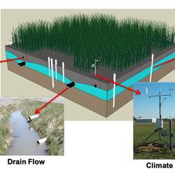
Illustration of subsurface-drained agricultural field
A hypothetical configuration of one of the two drained field sites, including a weather station for measuring climate data, a piezometer network for continuous water level measurements, soil moisture probes, and subsurface drainage flow. The third undrained field site will have a similar configuration, with the absence of subsurface drainage flow.

Grass carp larvae
These images show grass carp larvae from the Maumee River. Characteristics of larval grass carp include overall length (left), skeletal muscle development (center) and presence of an eye spot that lacks pigmentation (right; pigment starting to develop on lower eye).

Durand streamgage mounted to bridge
Durand streamgage mounted to bridge - looking downstream.

View from Durand bridge of boat crew conducting multibeam surveys
View from Durand bridge of boat crew conducting multibeam surveys

Hydro-tech using crane to collect a bedload sample from bridge
Hydrologic Technician using crane to collect a bedload sample from the bridge.

USGS scientists install a double ring infiltrometer
In this photo, USGS scientists Megan Haserodt (Hydrologist) and Jenelle Wempner (Student Intern) install a double ring infiltrometer along a recreated floodplain of Underwood Creek, a tributary to the Milwaukee River and Lake Michigan in Milwaukee, Wisconsin. The work is part of a larger study of how overbank flows and shallow groundwater in floodplains are connected for
...
Map dissolved oxygen and turbidity Milwaukee River
Map of dissolved oxygen and turbidity along the Milwaukee River.
These data are preliminary or provisional and are subject to revision. They are being provided to meet the need for timely best science.

White River in Downtown Indianapolis, IN
Photograph showing the White River downstream from the White River Trail bridge, looking east toward White River State Park in downtown Indianapolis, Indiana. Photograph by Matt Williams, The Nature Conservancy.
Reporters: Do you want to interview USGS scientists about the project? Please contact Randy Hines or Marisa Lubeck.
Note to Editors: In the public interest and in accordance with Federal Aviation Administration regulations, the USGS is announcing this low-level airborne project. Your assistance in informing the local communities is appreciated.
A total of $160,000 will fund new research and preserve important data across the Hoosier State
A total of $106,978 will fund new research and preserve important data across the Land of Lincoln

The scarcity or overabundance of water presents some of the most dangerous, damaging and costly threats to human life, ecosystems and property in the form of drought, floods and debris flows.

U.S. Geological Survey field crews are measuring record flooding on the Tittabawassee River in Midland, Michigan, following a heavy rainfall event.
U.S. Geological Survey field crews are measuring flooding across the country as spring weather is in full swing. Warming temperatures, increased precipitation and snowmelt have caused moderate to major flooding in the upper Midwest, East Coast, Central Plains and the Southeast portions of the country.

Budget Focuses on Bringing Science, Facilities, and Infrastructure into the 21st Century

Editor: In the public interest and in accordance with the Federal Aviation Administration regulations, the USGS is announcing this low-level airborne project. Your assistance in informing the local communities is appreciated.

The Marcellus Shale and Point Pleasant-Utica Shale formations of the Appalachian Basin contain an estimated mean of 214 trillion cubic feet of undiscovered, technically recoverable continuous resources of natural gas, according to new USGS assessments.

A genetic analysis conducted by the U.S. Geological Survey recently confirmed that larval, or newly hatched, fish collected from the Maumee River during the summer of 2018 are grass carp, one species of invasive Asian carps that threaten the Great Lakes. The Maumee River is a tributary to Lake Erie.

Two types of human-associated bacteria and three types of human viruses were detected in Milwaukee streams within the Menomonee River watershed, according to a recent study led by the U.S. Geological Survey.
Contacts
Locations


Upper Midwest Water Science Center - Middleton, Wis., Office
Phone: 608-828-9901
Fax: 608-821-3817

Kentucky - Louisville Office
mgriffin@usgs.gov
Phone: (502) 493-1900
Fax: (502) 493-1909

Ohio-Kentucky-Indiana Water Science Center

Kentucky - Williamsburg Field Office
mgriffin@usgs.gov
Phone: (606) 549-2406
Fax: (606) 549-5400

Kentucky - Murray Field Office
mgriffin@usgs.gov
Phone: (270) 759-2460
Fax: (270) 649-2461

Great Lakes Science Center
Phone: 734-994-3331
Fax: 734-994-8780

Illinois Water Science Center
Phone: 217-328-8747
Fax: 217-328-9770

Indiana - Indianapolis Office
mgriffin@usgs.gov
Phone: (317) 290-3333
Fax: (317) 290-3313

Upper Midwest Environmental Sciences Center
Phone: (608) 783-6451
Kentucky Water Science Center
Phone: (502) 493-1900
Fax: (502) 493-1909

Upper Midwest Water Science Center - Lansing, Mich., Office
Phone: 517-887-8903
Fax: 517-887-8937

National Wildlife Health Center
Phone: 608-270-2400
Fax: 608-270-2415
Upper Midwest Water Science Center - Mounds View, Minn., Office
Phone: 763-783-3100
Fax: 763-783-3103

Ohio - Columbus Office
mgriffin@usgs.gov
Phone: 614-430-7700
Fax: 614-430-7777
")
Ohio - Ohio Water Microbiology Laboratory (OWML)
mgriffin@usgs.gov
Phone: 614-430-7700
Fax: 614-430-7777

Laboratory for Infectious Disease and the Environment
Phone: 715-384-9673
Fax: 715-384-9157

Michigan Bacteriological Research Laboratory (MI-BaRL)
Phone: 517-887-8903
Fax: 517-887-8937

Mercury Research Laboratory
mercury@usgs.gov
Phone: 608-828-9901
Fax: 608-821-3817
Upper Midwest Water Science Center - Grand Rapids, Minn., Field Office
Phone: 218-326-1297
Fax: 218-327-2557

Cheboygan Vessel Base
jbergan@usgs.gov
Phone: 231-627-4571
Fax: 231-627-8791

Upper Midwest Water Science Center - Rhinelander, Wis., Field Office
Phone: 715-362-7476
Fax: 715-362-7479
")
Upper Midwest Water Science Center - Rice Lake, Wis., Field Office
Phone: 715-234-4015
Fax: 715-234-4550

Wisconsin Water Science Center - Southwest Field Office (Middleton)
Phone: 608-827-6255
Fax: 608-827-0851

Upper Midwest Water Science Center - Gladstone, Mich., Field Office
Phone: (906) 428-5800

Upper Midwest Water Science Center - Grayling, Mich., Field Office
Phone: 989-348-8291
Fax: 989-348-6866

Ohio - New Philadelphia Field Office
mgriffin@usgs.gov
Phone: 330-343-2343
Fax: 330-364-8095
Upper Midwest Water Science Center - Lansing, Mich., Field Office
Phone: 517-887-8903
Fax: 517-887-8937

Southern Illinois Field Office - Mt. Vernon
Phone: 618-242-4495
Fax: 618-242-4578
Northern Illinois Field Office - DeKalb
Phone: 815-756-9207
Fax: 815-756-9214

Hammond Bay Biological Station
michaelhansen@usgs.gov
Phone: 989-734-4768
Fax: 989-734-4494

Lake Erie Biological Station
rkraus@usgs.gov
Phone: 419-625-1976
Fax: 419-625-7164

Lake Michigan Ecological Research Station
Phone: 219-926--8336
Fax: 219-929-5792

Lake Superior Biological Station
mvinson@usgs.gov
Phone: 715-682-6163
Fax: 715-682-6511

Upper Midwest Water Science Center - Milwaukee, Wis., Project Office
Phone: 414-962-2582

Upper Midwest Water Science Center - Green Bay, Wis., Project Office
Phone: 920-655-0273