
Alaska Science Center
Multimedia
Weighing type precipitation gage and new radar-based sensor
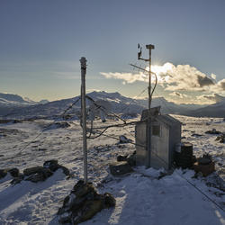
The Wolverine Glacier weather station was installed in 1968, and at 3250 ft is the highest elevation long-term weather record on the Kenai Peninsula. On October 19, 2020, USGS scientists upgraded the power system to a Lithium battery bank and installed a radar-based precipitation sensor (Lufft WS-100) to compare with the weighing based precipitation gage. From this angle
...
White-fronted goose flies over a nesting area near Point Lonely, AK
A white-fronted goose flies over a nesting area near Point Lonely, Alaska. For more information about this USGS study read "Effects of industrial and investigator disturbance on Arctic-nesting geese" at: https://pubs.er.usgs.gov/publication/70192845

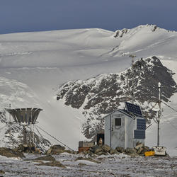
Wolverine Glacier weather station on the Kenai Peninsula, Alaska
The Wolverine Glacier weather station was installed in 1968, and at 3250 ft is the highest elevation long-term weather record on the Kenai Peninsula. On October 19, 2020, USGS scientists upgraded the power system to a Lithium battery bank and installed a radar-based precipitation sensor (Lufft WS-100) to compare with the weighing based precipitation gage. The data from
...
Upgraded Wolverine Glacier weather station, Alaska
The Wolverine Glacier weather station was installed in 1968, and at 3250 ft is the highest elevation long-term weather record on the Kenai Peninsula. In Ocotober 2020, USGS scientists upgraded the power system to a Lithium battery bank and installed a radar-based precipitation sensor (Lufft WS-100) to compare with the weighing based precipitation gage. The new radar-based
...
Close up of the new radar precipitation sensor on the top of the pole
The Wolverine Glacier weather station was installed in 1968, and at 3250 ft is the highest elevation long-term weather record on the Kenai Peninsula. Close up of the new radar precipitation sensor on the top of the pole. The crazy looking thing in the middle of the picture is an aspirated temperature sensor. Have you ever noticed a day where it feels really hot in the sun
...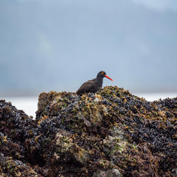
Black Oystercatcher on Gull Island, Alaska
Black Oystercatcher on Gull Island, Kachemak Bay, Alaska

Mapping river bathymetry in the Copper River Delta, Alaska
USGS scientists Robin Beebee (left) and Jeff Conaway use a boat-mounted multibeam echosounder to map river bathymetry around bridge piers in the Copper River Delta of Alaska. The bathymetric mapping is part of a streambed scour study conducted in cooperation with the Alaska Department of Transportation and Public Facilities.

Pelagic cormorant, Gull Island, Kachemak Bay Alaska
Pelagic cormorant, Gull Island, Kachemak Bay Alaska
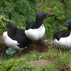
Thick-billed Murres on the Pribilof Islands
Thick-billed Murres on the Pribilof Islands

Scientists record nearshore transects in Kachemak Bay, Alaska
Brian Robinson (USGS) and Ben Weitzman (NOAA) record observations along nearshore transects in Kachemak Bay, Alaska. USGS is studying the migration strategies and movement ecology of Black Oystercatchers as part of the new tracking study.

Caitlin Marsteller prepares to release a Black Oystercatcher, Alaska
USGS Biologist Caitlin Marsteller prepares to release a Black Oystercatcher after assisting with the collection of morphometric data and tagging. Data were collected from Black Oystercatchers as part of a new study to better understand migration strategies and movement ecology of the species.

Caitlin Marsteller releases a Black Oystercatcher on beach in Alaska
USGS Biologist Caitlin Marsteller releases a Black Oystercatcher after assisting with the collection of morphometric data and tagging. Data were collected from Black Oystercatchers as part of a new study to better understand migration strategies and movement ecology of the species.