Map
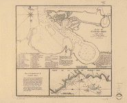
Mapa topográfico de la Isla de San Juan de Puerto Rico y la de bieque con la division de sus partidos /

| Format |
Map |
|---|---|
| Contributors |
LóPez De Vargas Machuca, TomáS LóPez De Vargas Machuca, TomáS |
| Dates |
1791 |
| Location |
Puerto Rico |
| Language |
Castilian Spanish |
| Subjects |
Puerto Rico |
- Title
- Mapa topográfico de la Isla de San Juan de Puerto Rico y la de bieque con la division de sus partidos /
- Description
-
Relief shown by hachures.
-
Prime meridian: Tenerife.
-
Available also through the Library of Congress Web site as a raster image.
-
Includes text.
-
1 map : hand col. ; 35 x 72 cm.
- Creator
- López de Vargas Machuca, Tomás,
- Created Published
-
Madrid : [s.n.], 1791.
- Subject Headings
-
-
Puerto Rico
-
-
Puerto Rico.
- Notes
-
-
Relief shown by hachures.
-
-
Prime meridian: Tenerife.
-
-
Available also through the Library of Congress Web site as a raster image.
-
-
Includes text.
- Medium
-
1 map : hand col. ; 35 x 72 cm.
- Call Number
-
G4970 1791 .L6
- Repository
-
Library of Congress Geography and Map Division Washington, D.C. 20540-4650 USA dcu
- Digital Id
-
g4970 ct001214 http://hdl.loc.gov/loc.gmd/g4970.ct001214
- Library of Congress Catalog Number
- 99463770
Rights & Access
The maps in the Map Collections materials were either published prior to 1922, produced by the United States government, or both (see catalogue records that accompany each map for information regarding date of publication and source). The Library of Congress is providing access to these materials for educational and research purposes and is not aware of any U.S. copyright protection (see Title 17 of the United States Code) or any other restrictions in the Map Collection materials.
Note that the written permission of the copyright owners and/or other rights holders (such as publicity and/or privacy rights) is required for distribution, reproduction, or other use of protected items beyond that allowed by fair use or other statutory exemptions. Responsibility for making an independent legal assessment of an item and securing any necessary permissions ultimately rests with persons desiring to use the item.
More about Copyright and other Restrictions
For guidance about compiling full citations consult Citing Primary Sources.
Part of...
-
General Maps
[2477]
-
Geography And Maps Division
[60803]
-
American Memory
[1121009]
More maps like this
-
 Plano de Puerto-Rico: Dale a Luz.
Contributor:
López de Vargas Machuca, Tomás, López de Vargas Machuca, Tomás
Site:
American Memory-cultural, Main Catalog
Original Format:
Map
Date:
1785
View catalog record
Plano de Puerto-Rico: Dale a Luz.
Contributor:
López de Vargas Machuca, Tomás, López de Vargas Machuca, Tomás
Site:
American Memory-cultural, Main Catalog
Original Format:
Map
Date:
1785
View catalog record
-
 Plano de la plaza y ciudad de Santo Domingo, capital de la isla Española;
Contributor:
López de Vargas Machuca, Tomás, López de Vargas Machuca, Tomás
Site:
American Memory-cultural, Main Catalog
Original Format:
Map
Date:
1785
View catalog record
Plano de la plaza y ciudad de Santo Domingo, capital de la isla Española;
Contributor:
López de Vargas Machuca, Tomás, López de Vargas Machuca, Tomás
Site:
American Memory-cultural, Main Catalog
Original Format:
Map
Date:
1785
View catalog record
-
 Carta de la isla de la Jamayca; dividida en diez y nueve parroquias ó quarteles.
Contributor:
López de Vargas Machuca, Tomás, López de Vargas Machuca, Tomás
Site:
American Memory-cultural, Main Catalog
Original Format:
Map
Date:
1780
View catalog record
Carta de la isla de la Jamayca; dividida en diez y nueve parroquias ó quarteles.
Contributor:
López de Vargas Machuca, Tomás, López de Vargas Machuca, Tomás
Site:
American Memory-cultural, Main Catalog
Original Format:
Map
Date:
1780
View catalog record
-
 Mapa maritimo del Golfo de Mexico e islas de la America, para el uso de los navegantes en esta parte del mundo, construido sobre las ...
Contributor:
López de Vargas Machuca, Tomás, López de Vargas Machuca, Tomás
Site:
American Memory-cultural, Main Catalog
Original Format:
Map
Date:
1755
View catalog record
Mapa maritimo del Golfo de Mexico e islas de la America, para el uso de los navegantes en esta parte del mundo, construido sobre las ...
Contributor:
López de Vargas Machuca, Tomás, López de Vargas Machuca, Tomás
Site:
American Memory-cultural, Main Catalog
Original Format:
Map
Date:
1755
View catalog record
-
 Plano de la ciudad y puerto de la Havana.
Contributor:
López de Vargas Machuca, Tomás, López de Vargas Machuca, Tomás
Site:
American Memory-cultural, Main Catalog
Original Format:
Map
Date:
1785
View catalog record
Plano de la ciudad y puerto de la Havana.
Contributor:
López de Vargas Machuca, Tomás, López de Vargas Machuca, Tomás
Site:
American Memory-cultural, Main Catalog
Original Format:
Map
Date:
1785
View catalog record
-
 Plano de la ciudad y puerto de San Agustin de la Florida.
Contributor:
López de Vargas Machuca, Tomás, López de Vargas Machuca, Tomás
Site:
American Memory-cultural, Main Catalog
Original Format:
Map
Date:
1783
View catalog record
Plano de la ciudad y puerto de San Agustin de la Florida.
Contributor:
López de Vargas Machuca, Tomás, López de Vargas Machuca, Tomás
Site:
American Memory-cultural, Main Catalog
Original Format:
Map
Date:
1783
View catalog record
-
 La Luisiana cedida al Rei N. S. por S. M. Christianisima, con la Nueva Orleans, è isla en que se halla esta ciudad. Construida sobre ...
Contributor:
López de Vargas Machuca, Tomás, López de Vargas Machuca, Tomás
Site:
American Memory-cultural, Main Catalog
Original Format:
Map
Date:
1762
View catalog record
La Luisiana cedida al Rei N. S. por S. M. Christianisima, con la Nueva Orleans, è isla en que se halla esta ciudad. Construida sobre ...
Contributor:
López de Vargas Machuca, Tomás, López de Vargas Machuca, Tomás
Site:
American Memory-cultural, Main Catalog
Original Format:
Map
Date:
1762
View catalog record
-
 Carta general de las islas Antillas Menores, llamadas de Barlovento, y tambien Caribes:
Contributor:
López de Vargas Machuca, Tomás, López de Vargas Machuca, Tomás
Site:
American Memory-cultural, Main Catalog
Original Format:
Map
Date:
1781
View catalog record
Carta general de las islas Antillas Menores, llamadas de Barlovento, y tambien Caribes:
Contributor:
López de Vargas Machuca, Tomás, López de Vargas Machuca, Tomás
Site:
American Memory-cultural, Main Catalog
Original Format:
Map
Date:
1781
View catalog record
-
 Puerto Rico e islas limítrofes /
Contributor:
Geological Survey (U.S.)
Site:
American Memory-cultural, Main Catalog
Original Format:
Map
Date:
1952
View catalog record
Puerto Rico e islas limítrofes /
Contributor:
Geological Survey (U.S.)
Site:
American Memory-cultural, Main Catalog
Original Format:
Map
Date:
1952
View catalog record
-
 Latest map of island of Porto[sic] Rico, new territory U.S.A. /
Contributor:
Lago, J. M.
Site:
American Memory-cultural, Main Catalog
Original Format:
Map
Date:
1898
View catalog record
Latest map of island of Porto[sic] Rico, new territory U.S.A. /
Contributor:
Lago, J. M.
Site:
American Memory-cultural, Main Catalog
Original Format:
Map
Date:
1898
View catalog record
-
 Plano de la isla de Puerto-Rico, con el alumbrado maritimo.
Site:
American Memory-cultural, Main Catalog
Original Format:
Map
View catalog record
Plano de la isla de Puerto-Rico, con el alumbrado maritimo.
Site:
American Memory-cultural, Main Catalog
Original Format:
Map
View catalog record
-
 Map of the island of Porto Rico showing the lines of signal communication, telegraph, telephone, and heliograph, operated by the Signals Corps, U.S. Army, with ...
Contributor:
Glassford, William A.
Site:
American Memory-cultural, Main Catalog
Original Format:
Map
Date:
1900
View catalog record
Map of the island of Porto Rico showing the lines of signal communication, telegraph, telephone, and heliograph, operated by the Signals Corps, U.S. Army, with ...
Contributor:
Glassford, William A.
Site:
American Memory-cultural, Main Catalog
Original Format:
Map
Date:
1900
View catalog record
-
 Rand McNally 14 x 21 inch map of Porto Rico.
Contributor:
Rand McNally and Company
Site:
American Memory-cultural, Main Catalog
Original Format:
Map
Date:
1921
View catalog record
Rand McNally 14 x 21 inch map of Porto Rico.
Contributor:
Rand McNally and Company
Site:
American Memory-cultural, Main Catalog
Original Format:
Map
Date:
1921
View catalog record
-
 Plano de la aguada de St. Francisco en la ysla de St. Iuan de Puerto Rico. Las dos linias de carmin el punto donde se ...
Contributor:
Celi, Francisco Mathias
Site:
American Memory-cultural, Main Catalog
Original Format:
Map
Date:
1740
View catalog record
Plano de la aguada de St. Francisco en la ysla de St. Iuan de Puerto Rico. Las dos linias de carmin el punto donde se ...
Contributor:
Celi, Francisco Mathias
Site:
American Memory-cultural, Main Catalog
Original Format:
Map
Date:
1740
View catalog record
-
 Plano d. las aguadas d. Sn. Juan y Sn. Franco. d. Añasco en la ysla de Pto. Rico, año d. 1787.
Site:
American Memory-cultural, Main Catalog
Original Format:
Map
Date:
1787
View catalog record
Plano d. las aguadas d. Sn. Juan y Sn. Franco. d. Añasco en la ysla de Pto. Rico, año d. 1787.
Site:
American Memory-cultural, Main Catalog
Original Format:
Map
Date:
1787
View catalog record
-
 Map of the island of Porto Rico.
Contributor:
Rand McNally and Company
Site:
American Memory-cultural, Main Catalog
Original Format:
Map
Date:
1915
View catalog record
Map of the island of Porto Rico.
Contributor:
Rand McNally and Company
Site:
American Memory-cultural, Main Catalog
Original Format:
Map
Date:
1915
View catalog record
You might also like
-

 Facts of Porto Rican history for grammar school pupils,
Contributor:
Clopper, Edward Nicholas
Site:
Main Catalog
Original Format:
Book
Date:
1906
Facts of Porto Rican history for grammar school pupils,
Contributor:
Clopper, Edward Nicholas
Site:
Main Catalog
Original Format:
Book
Date:
1906
-
La autonomía administrativa en Puerto-Rico /
Contributor:
Dominguez, José de Jésus
Site:
Main Catalog
Original Format:
Book
Date:
1887
-
Just a word for Porto Rico,
Contributor:
Capó-Rodriguez, Pedro
Site:
Main Catalog
Original Format:
Book
Date:
1918
-
Some historical and political aspects of the government of Porto Rico,
Contributor:
Capó Rodríguez, Pedro
Site:
Main Catalog
Original Format:
Book
Date:
1919
-
Historia de Puerto Rico,
Contributor:
Miller, Paul G.
Site:
Main Catalog
Original Format:
Book
Date:
1922
-
Child of the sea;
Contributor:
Duggan, Janie Prichard
Site:
Main Catalog
Original Format:
Book
Date:
1920