Map
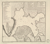
Mapa maritimo del Golfo de Mexico e islas de la America, para el uso de los navegantes en esta parte del mundo, construido sobre las mexores memorias, y observaciones astronomicas de longitudes, y latitudes.

| Format |
Map |
|---|---|
| Contributors |
LóPez De Vargas Machuca, TomáS LóPez De Vargas Machuca, TomáS |
| Dates |
1755 |
| Location |
Caribbean Area |
| Language |
Castilian Spanish |
| Subjects |
Caribbean Area Nautical Charts |
- Title
- Mapa maritimo del Golfo de Mexico e islas de la America, para el uso de los navegantes en esta parte del mundo, construido sobre las mexores memorias, y observaciones astronomicas de longitudes, y latitudes.
- Description
-
Scale ca. 1:5,500,000.
-
Depths shown by soundings.
-
"Longitud ocidental del meridiano de Tenerife."
-
LC Maps of North America, 1750-1789, 1685
-
Available also through the Library of Congress Web site as a raster image.
-
map 56 x 79 cm.
- Creator
- López de Vargas Machuca, Tomás,
- Created Published
-
[Madrid] 1755.
- Subject Headings
-
-
Nautical charts--Caribbean Area
-
-
Caribbean Area
-
-
Caribbean Area.
- Notes
-
-
Scale ca. 1:5,500,000.
-
-
Depths shown by soundings.
-
-
"Longitud ocidental del meridiano de Tenerife."
-
-
LC Maps of North America, 1750-1789, 1685
-
-
Available also through the Library of Congress Web site as a raster image.
- Medium
-
map 56 x 79 cm.
- Call Number
-
G4391.P5 1755 .L6
- Repository
-
Library of Congress Geography and Map Division Washington, D.C. 20540-4650 USA dcu
- Digital Id
-
g4391p ar168501 http://hdl.loc.gov/loc.gmd/g4391p.ar168501
- Library of Congress Catalog Number
- 74696149
Rights & Access
The maps in the Map Collections materials were either published prior to 1922, produced by the United States government, or both (see catalogue records that accompany each map for information regarding date of publication and source). The Library of Congress is providing access to these materials for educational and research purposes and is not aware of any U.S. copyright protection (see Title 17 of the United States Code) or any other restrictions in the Map Collection materials.
Note that the written permission of the copyright owners and/or other rights holders (such as publicity and/or privacy rights) is required for distribution, reproduction, or other use of protected items beyond that allowed by fair use or other statutory exemptions. Responsibility for making an independent legal assessment of an item and securing any necessary permissions ultimately rests with persons desiring to use the item.
More about Copyright and other Restrictions
For guidance about compiling full citations consult Citing Primary Sources.
Part of...
More maps like this
-
 Plano de Puerto-Rico: Dale a Luz.
Contributor:
López de Vargas Machuca, Tomás, López de Vargas Machuca, Tomás
Site:
American Memory-cultural, Main Catalog
Original Format:
Map
Date:
1785
View catalog record
Plano de Puerto-Rico: Dale a Luz.
Contributor:
López de Vargas Machuca, Tomás, López de Vargas Machuca, Tomás
Site:
American Memory-cultural, Main Catalog
Original Format:
Map
Date:
1785
View catalog record
-
 Plano de la plaza y ciudad de Santo Domingo, capital de la isla Española;
Contributor:
López de Vargas Machuca, Tomás, López de Vargas Machuca, Tomás
Site:
American Memory-cultural, Main Catalog
Original Format:
Map
Date:
1785
View catalog record
Plano de la plaza y ciudad de Santo Domingo, capital de la isla Española;
Contributor:
López de Vargas Machuca, Tomás, López de Vargas Machuca, Tomás
Site:
American Memory-cultural, Main Catalog
Original Format:
Map
Date:
1785
View catalog record
-
 Carta de la isla de la Jamayca; dividida en diez y nueve parroquias ó quarteles.
Contributor:
López de Vargas Machuca, Tomás, López de Vargas Machuca, Tomás
Site:
American Memory-cultural, Main Catalog
Original Format:
Map
Date:
1780
View catalog record
Carta de la isla de la Jamayca; dividida en diez y nueve parroquias ó quarteles.
Contributor:
López de Vargas Machuca, Tomás, López de Vargas Machuca, Tomás
Site:
American Memory-cultural, Main Catalog
Original Format:
Map
Date:
1780
View catalog record
-
 Mapa topográfico de la Isla de San Juan de Puerto Rico y la de bieque con la division de sus partidos /
Contributor:
López de Vargas Machuca, Tomás, López de Vargas Machuca, Tomás
Site:
American Memory-cultural, Main Catalog
Original Format:
Map
Date:
1791
View catalog record
Mapa topográfico de la Isla de San Juan de Puerto Rico y la de bieque con la division de sus partidos /
Contributor:
López de Vargas Machuca, Tomás, López de Vargas Machuca, Tomás
Site:
American Memory-cultural, Main Catalog
Original Format:
Map
Date:
1791
View catalog record
-
 Plano de la ciudad y puerto de la Havana.
Contributor:
López de Vargas Machuca, Tomás, López de Vargas Machuca, Tomás
Site:
American Memory-cultural, Main Catalog
Original Format:
Map
Date:
1785
View catalog record
Plano de la ciudad y puerto de la Havana.
Contributor:
López de Vargas Machuca, Tomás, López de Vargas Machuca, Tomás
Site:
American Memory-cultural, Main Catalog
Original Format:
Map
Date:
1785
View catalog record
-
 Plano de la ciudad y puerto de San Agustin de la Florida.
Contributor:
López de Vargas Machuca, Tomás, López de Vargas Machuca, Tomás
Site:
American Memory-cultural, Main Catalog
Original Format:
Map
Date:
1783
View catalog record
Plano de la ciudad y puerto de San Agustin de la Florida.
Contributor:
López de Vargas Machuca, Tomás, López de Vargas Machuca, Tomás
Site:
American Memory-cultural, Main Catalog
Original Format:
Map
Date:
1783
View catalog record
-
 La Luisiana cedida al Rei N. S. por S. M. Christianisima, con la Nueva Orleans, è isla en que se halla esta ciudad. Construida sobre ...
Contributor:
López de Vargas Machuca, Tomás, López de Vargas Machuca, Tomás
Site:
American Memory-cultural, Main Catalog
Original Format:
Map
Date:
1762
View catalog record
La Luisiana cedida al Rei N. S. por S. M. Christianisima, con la Nueva Orleans, è isla en que se halla esta ciudad. Construida sobre ...
Contributor:
López de Vargas Machuca, Tomás, López de Vargas Machuca, Tomás
Site:
American Memory-cultural, Main Catalog
Original Format:
Map
Date:
1762
View catalog record
-
 Carta general de las islas Antillas Menores, llamadas de Barlovento, y tambien Caribes:
Contributor:
López de Vargas Machuca, Tomás, López de Vargas Machuca, Tomás
Site:
American Memory-cultural, Main Catalog
Original Format:
Map
Date:
1781
View catalog record
Carta general de las islas Antillas Menores, llamadas de Barlovento, y tambien Caribes:
Contributor:
López de Vargas Machuca, Tomás, López de Vargas Machuca, Tomás
Site:
American Memory-cultural, Main Catalog
Original Format:
Map
Date:
1781
View catalog record
-
 Carte du Golphe du Mexique et des isles Antilles, reduite de la grande carte angloise de Popple,
Contributor:
Buache, Philippe
Site:
American Memory-cultural, Main Catalog
Original Format:
Map
Date:
1789
View catalog record
Carte du Golphe du Mexique et des isles Antilles, reduite de la grande carte angloise de Popple,
Contributor:
Buache, Philippe
Site:
American Memory-cultural, Main Catalog
Original Format:
Map
Date:
1789
View catalog record
-
 Carte du Golphe du Mexique et des isles Antilles, reduite de la grande carte angloise de Popple,
Contributor:
Buache, Philippe
Site:
American Memory-cultural, Main Catalog
Original Format:
Map
Date:
1780
View catalog record
Carte du Golphe du Mexique et des isles Antilles, reduite de la grande carte angloise de Popple,
Contributor:
Buache, Philippe
Site:
American Memory-cultural, Main Catalog
Original Format:
Map
Date:
1780
View catalog record
-
 A new general chart of the West Indies, from the latest marine journals and surveys; regulated and ascertained by astronomical observations. I, the subscriber, do ...
Contributor:
Carleton, Osgood
Site:
American Memory-cultural, Main Catalog
Original Format:
Map
Date:
1789
View catalog record
A new general chart of the West Indies, from the latest marine journals and surveys; regulated and ascertained by astronomical observations. I, the subscriber, do ...
Contributor:
Carleton, Osgood
Site:
American Memory-cultural, Main Catalog
Original Format:
Map
Date:
1789
View catalog record
-
 Mapa y plano del Seno Mexicano. Contodas las costas, de tierra firme ẽ yslas de barlovento consus adyacentes, recopiladas, sus-latitudes y longitudes en el puerto ...
Contributor:
San Martín Suárez, José de, San Martín Suárez, José de
Site:
American Memory-cultural, Main Catalog
Original Format:
Map
Date:
1787
View catalog record
Mapa y plano del Seno Mexicano. Contodas las costas, de tierra firme ẽ yslas de barlovento consus adyacentes, recopiladas, sus-latitudes y longitudes en el puerto ...
Contributor:
San Martín Suárez, José de, San Martín Suárez, José de
Site:
American Memory-cultural, Main Catalog
Original Format:
Map
Date:
1787
View catalog record
-
 Descripcion de las costas, islas placeres, i bajos delas, Indias Occidentales,
Contributor:
Espinosa, Pedro Alcantara
Site:
American Memory-cultural, Main Catalog
Original Format:
Map
Date:
1765
View catalog record
Descripcion de las costas, islas placeres, i bajos delas, Indias Occidentales,
Contributor:
Espinosa, Pedro Alcantara
Site:
American Memory-cultural, Main Catalog
Original Format:
Map
Date:
1765
View catalog record
-
 Les isles Antilles, et le golfe du Méxique.
Contributor:
Bonne, Rigobert
Site:
American Memory-cultural, Main Catalog
Original Format:
Map
Date:
1780
View catalog record
Les isles Antilles, et le golfe du Méxique.
Contributor:
Bonne, Rigobert
Site:
American Memory-cultural, Main Catalog
Original Format:
Map
Date:
1780
View catalog record
-
 Karte von dem Mexicanischen Meerbusen und dem Inseln von America, zur Allgemeinen Historie der Reisen.
Contributor:
Bellin, Jacques Nicolas
Site:
American Memory-cultural, Main Catalog
Original Format:
Map
Date:
1754
View catalog record
Karte von dem Mexicanischen Meerbusen und dem Inseln von America, zur Allgemeinen Historie der Reisen.
Contributor:
Bellin, Jacques Nicolas
Site:
American Memory-cultural, Main Catalog
Original Format:
Map
Date:
1754
View catalog record
-
 L'ancien et le nouveau Méxique, avec la Floride et la Basse Louisiane, partie orientale.
Contributor:
Bonne, Rigobert
Site:
American Memory-cultural, Main Catalog
Original Format:
Map
Date:
1788
View catalog record
L'ancien et le nouveau Méxique, avec la Floride et la Basse Louisiane, partie orientale.
Contributor:
Bonne, Rigobert
Site:
American Memory-cultural, Main Catalog
Original Format:
Map
Date:
1788
View catalog record
You might also like
-

 The color of desire [and] Hurricane : two plays /
Contributor:
Cruz, Nilo
Site:
Main Catalog
Original Format:
Book
Date:
2011
The color of desire [and] Hurricane : two plays /
Contributor:
Cruz, Nilo
Site:
Main Catalog
Original Format:
Book
Date:
2011
-
 Group of children in street
Contributor:
Rhoads, Harry Mellon
Site:
American Memory-cultural
Original Format:
Photo, Print, Drawing
Date:
1920
Group of children in street
Contributor:
Rhoads, Harry Mellon
Site:
American Memory-cultural
Original Format:
Photo, Print, Drawing
Date:
1920
-
-
 Man & woman on deck of "Str. Osceola, New York"
Contributor:
Rhoads, Harry Mellon
Site:
American Memory-cultural
Original Format:
Photo, Print, Drawing
Date:
1920
Man & woman on deck of "Str. Osceola, New York"
Contributor:
Rhoads, Harry Mellon
Site:
American Memory-cultural
Original Format:
Photo, Print, Drawing
Date:
1920
-
Reefs at risk in the Caribbean /
Contributor:
Burke, Lauretta Marie
Site:
Main Catalog
Original Format:
Book
Date:
2004
-
 Street scene
Contributor:
Rhoads, Harry Mellon
Site:
American Memory-cultural
Original Format:
Photo, Print, Drawing
Date:
1900
Street scene
Contributor:
Rhoads, Harry Mellon
Site:
American Memory-cultural
Original Format:
Photo, Print, Drawing
Date:
1900