Map
Baist's real estate atlas of surveys of Washington, District of Columbia : complete in four volumes /
Views

More Views

| Format |
Map |
|---|---|
| Contributors |
Baist, G. Wm |
| Dates |
1907 |
| Location |
United States Washington Washington D.C. |
| Language |
English |
| Subjects |
District of Columbia Real Property United States Washington Washington (D.C.) |
- Title
- Baist's real estate atlas of surveys of Washington, District of Columbia : complete in four volumes /
- Description
-
Phillips 1506
-
Available also through the Library of Congress Web site as a raster image.
-
v. 3. [N.W. section, north of Florida Ave.] -- v. 4. [N.E. section north of Florida Ave., and S.E. section east of Anacostia River].
-
1 atlas (v. <3-4 > : col. maps ; 61 cm.
- Creator
- Baist, G. Wm.
- Created Published
-
Philadelphia : G.W. Baist, 1907-
- Subject Headings
-
-
Washington (D.C.)
-
-
Real property--Washington (D.C.)
-
-
United States--District of Columbia--Washington.
- Notes
-
-
Phillips 1506
-
-
Available also through the Library of Congress Web site as a raster image.
-
-
v. 3. [N.W. section, north of Florida Ave.] -- v. 4. [N.E. section north of Florida Ave., and S.E. section east of Anacostia River].
- Medium
-
1 atlas (v. <3-4 > : col. maps ; 61 cm.
- Call Number
-
G1275 .B2 1907
- Repository
-
Library of Congress Geography and Map Division Washington, D.C. 20540-4650 USA dcu
- Digital Id
-
g3851bm gct00132c http://hdl.loc.gov/loc.gmd/g3851bm.gct00132c
-
g3851bm gct00132d http://hdl.loc.gov/loc.gmd/g3851bm.gct00132d
- Library of Congress Catalog Number
- 87675193
Rights & Access
The maps in the Map Collections materials were either published prior to 1922, produced by the United States government, or both (see catalogue records that accompany each map for information regarding date of publication and source). The Library of Congress is providing access to these materials for educational and research purposes and is not aware of any U.S. copyright protection (see Title 17 of the United States Code) or any other restrictions in the Map Collection materials.
Note that the written permission of the copyright owners and/or other rights holders (such as publicity and/or privacy rights) is required for distribution, reproduction, or other use of protected items beyond that allowed by fair use or other statutory exemptions. Responsibility for making an independent legal assessment of an item and securing any necessary permissions ultimately rests with persons desiring to use the item.
More about Copyright and other Restrictions
For guidance about compiling full citations consult Citing Primary Sources.
Part of...
-
Cities And Towns
[1965]
-
Geography And Maps Division
[60803]
-
American Memory
[1121009]
More maps like this
-
 Baist's real estate atlas of surveys of Washington, District of Columbia : complete in four volumes /
Contributor:
Baist, G. Wm
Site:
American Memory-cultural, Main Catalog
Original Format:
Map
Date:
1909
View catalog record
Baist's real estate atlas of surveys of Washington, District of Columbia : complete in four volumes /
Contributor:
Baist, G. Wm
Site:
American Memory-cultural, Main Catalog
Original Format:
Map
Date:
1909
View catalog record
-
Baist's real estate atlas of surveys of Washington, District of Columbia : complete in four volumes /
Contributor:
Baist, G. Wm
Site:
American Memory-cultural, Main Catalog
Original Format:
Map
Date:
1919
View catalog record
-
Baist's real estate atlas of surveys of Washington, District of Columbia : complete in four volumes /
Contributor:
Baist, G. Wm
Site:
American Memory-cultural, Main Catalog
Original Format:
Map
Date:
1913
View catalog record
-
Baist's real estate atlas of surveys of Washington, District of Columbia : complete in three volumes /
Contributor:
Baist, G. Wm
Site:
American Memory-cultural, Main Catalog
Original Format:
Map
Date:
1903
View catalog record
-
 Baist's real estate atlas of surveys of Indianapolis and vicinity, Indiana : complete in one volume : compiled and published from official records, private plans ...
Contributor:
Baist, G. Wm
Site:
American Memory-cultural, Main Catalog
Original Format:
Map
Date:
1916
View catalog record
Baist's real estate atlas of surveys of Indianapolis and vicinity, Indiana : complete in one volume : compiled and published from official records, private plans ...
Contributor:
Baist, G. Wm
Site:
American Memory-cultural, Main Catalog
Original Format:
Map
Date:
1916
View catalog record
-
 Baist's real estate atlas of surveys of Indianapolis and vicinity, Indiana : complete in one volume : compiled and published from official records, private plans ...
Contributor:
Baist, G. Wm
Site:
American Memory-cultural, Main Catalog
Original Format:
Map
Date:
1908
View catalog record
Baist's real estate atlas of surveys of Indianapolis and vicinity, Indiana : complete in one volume : compiled and published from official records, private plans ...
Contributor:
Baist, G. Wm
Site:
American Memory-cultural, Main Catalog
Original Format:
Map
Date:
1908
View catalog record
-
 Atlas of the Wyoming and Lackawanna Valleys and map of Luzerne and Lackawanna counties, Penna. : from actual surveys, official records & private plans /
Contributor:
Baist, G. Wm
Site:
American Memory-cultural, Main Catalog
Original Format:
Map
Date:
1894
View catalog record
Atlas of the Wyoming and Lackawanna Valleys and map of Luzerne and Lackawanna counties, Penna. : from actual surveys, official records & private plans /
Contributor:
Baist, G. Wm
Site:
American Memory-cultural, Main Catalog
Original Format:
Map
Date:
1894
View catalog record
-
 [Cadastral survey map of Charles Carroll Jr.'s land in central Washington D.C. in 1793].
Contributor:
Priggs, John F. A.
Site:
American Memory-cultural, Main Catalog
Original Format:
Map
Date:
1890
View catalog record
[Cadastral survey map of Charles Carroll Jr.'s land in central Washington D.C. in 1793].
Contributor:
Priggs, John F. A.
Site:
American Memory-cultural, Main Catalog
Original Format:
Map
Date:
1890
View catalog record
-
 Plan of the city of Washington in the territory of Columbia : ceded by the states of Virginia and Maryland to the United States of ...
Contributor:
Ellicott, Andrew
Site:
American Memory-cultural, Main Catalog
Original Format:
Map
Date:
1792
View catalog record
Plan of the city of Washington in the territory of Columbia : ceded by the states of Virginia and Maryland to the United States of ...
Contributor:
Ellicott, Andrew
Site:
American Memory-cultural, Main Catalog
Original Format:
Map
Date:
1792
View catalog record
-
 Birds eye view of Barnes & Weaver's addition to Brookland /
Contributor:
Gedney & Roberts
Site:
American Memory-cultural, Main Catalog
Original Format:
Map
Date:
1895
View catalog record
Birds eye view of Barnes & Weaver's addition to Brookland /
Contributor:
Gedney & Roberts
Site:
American Memory-cultural, Main Catalog
Original Format:
Map
Date:
1895
View catalog record
-
 Map of Washington City, District of Columbia, seat of the federal government : respectfully dedicated to the Senate and the House of Representatives of the ...
Contributor:
Boschke, A.
Site:
American Memory-cultural, Main Catalog
Original Format:
Map
Date:
1857
View catalog record
Map of Washington City, District of Columbia, seat of the federal government : respectfully dedicated to the Senate and the House of Representatives of the ...
Contributor:
Boschke, A.
Site:
American Memory-cultural, Main Catalog
Original Format:
Map
Date:
1857
View catalog record
-
 Sketch of Washington in embryo : viz., previous to its survey by Major L'Enfant, 1792 /
Contributor:
Faehtz, E. F. M.
Site:
American Memory-cultural, Main Catalog
Original Format:
Map
Date:
1893
View catalog record
Sketch of Washington in embryo : viz., previous to its survey by Major L'Enfant, 1792 /
Contributor:
Faehtz, E. F. M.
Site:
American Memory-cultural, Main Catalog
Original Format:
Map
Date:
1893
View catalog record
-
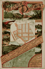 Palisades of the Potomac, scenery unsurpassed : embracing the additions to Washington of Drovers Rest, White Haven, Toronto Heights, and River View, adjoining Washington and ...
Contributor:
Brewer, H. W.
Site:
American Memory-cultural, Main Catalog
Original Format:
Map
Date:
1890
View catalog record
Palisades of the Potomac, scenery unsurpassed : embracing the additions to Washington of Drovers Rest, White Haven, Toronto Heights, and River View, adjoining Washington and ...
Contributor:
Brewer, H. W.
Site:
American Memory-cultural, Main Catalog
Original Format:
Map
Date:
1890
View catalog record
-
 View of the city of Washington in 1792.
Site:
American Memory-cultural, Main Catalog
Original Format:
Map
Date:
1860
View catalog record
View of the city of Washington in 1792.
Site:
American Memory-cultural, Main Catalog
Original Format:
Map
Date:
1860
View catalog record
-
 [Map of the fortifications within the District of Columbia].
Contributor:
United States. Army of the Potomac
Site:
American Memory-cultural, Main Catalog
Original Format:
Map
Date:
1862
View catalog record
[Map of the fortifications within the District of Columbia].
Contributor:
United States. Army of the Potomac
Site:
American Memory-cultural, Main Catalog
Original Format:
Map
Date:
1862
View catalog record
-
 [Partial cadastral map of southern part of Georgetown, Washington D.C.].
Contributor:
King, N.
Site:
American Memory-cultural, Main Catalog
Original Format:
Map
Date:
1799
View catalog record
[Partial cadastral map of southern part of Georgetown, Washington D.C.].
Contributor:
King, N.
Site:
American Memory-cultural, Main Catalog
Original Format:
Map
Date:
1799
View catalog record

