Map
Atlas of the Wyoming and Lackawanna Valleys and map of Luzerne and Lackawanna counties, Penna. : from actual surveys, official records & private plans /
Views

- Title
- Atlas of the Wyoming and Lackawanna Valleys and map of Luzerne and Lackawanna counties, Penna. : from actual surveys, official records & private plans /
- Description
-
Available also through the Library of Congress Web site as a raster image.
-
LC copy imperfect: Front and back boards separated from binding. DLC
-
1 atlas ([49] p.) : hand col. maps ; 50 cm.
- Creator
- Baist, G. Wm.
- Created Published
-
Philadelphia : G. Wm. Baist, 1894.
- Subject Headings
-
-
Wyoming Valley (Pa.)
-
-
Real property--Pennsylvania--Wyoming Valley
-
-
Landowners--Pennsylvania--Wyoming Valley
-
-
Lackawanna River Valley (Pa.)
-
-
Real property--Pennsylvania--Lackawanna River Valley
-
-
Landowners--Pennsylvania--Lackawanna River Valley
-
-
Luzerne County (Pa.)
-
-
Real property--Pennsylvania--Luzerne County
-
-
Landowners--Pennsylvania--Luzerne County
-
-
Lackawanna County (Pa.)
-
-
Real property--Pennsylvania--Lackawanna County
-
-
Landowners--Pennsylvania--Lackawanna County
-
-
United States--Pennsylvania--Wyoming Valley.
-
-
United States--Pennsylvania--Lackawanna River Valley.
-
-
United States--Pennsylvania--Lackawanna County.
-
-
United States--Pennsylvania--Luzerne County.
- Notes
-
-
Available also through the Library of Congress Web site as a raster image.
-
-
LC copy imperfect: Front and back boards separated from binding. DLC
- Medium
-
1 atlas ([49] p.) : hand col. maps ; 50 cm.
- Call Number
-
G1262.W95 B3 1894
- Repository
-
Library of Congress Geography and Map Division Washington, D.C. 20540-4650 USA dcu
- Digital Id
-
g3822wm gla00091 http://hdl.loc.gov/loc.gmd/g3822wm.gla00091
- Library of Congress Catalog Number
- 2006627639
Rights & Access
The maps in the Map Collections materials were either published prior to 1922, produced by the United States government, or both (see catalogue records that accompany each map for information regarding date of publication and source). The Library of Congress is providing access to these materials for educational and research purposes and is not aware of any U.S. copyright protection (see Title 17 of the United States Code) or any other restrictions in the Map Collection materials.
Note that the written permission of the copyright owners and/or other rights holders (such as publicity and/or privacy rights) is required for distribution, reproduction, or other use of protected items beyond that allowed by fair use or other statutory exemptions. Responsibility for making an independent legal assessment of an item and securing any necessary permissions ultimately rests with persons desiring to use the item.
More about Copyright and other Restrictions
For guidance about compiling full citations consult Citing Primary Sources.
Part of...
-
Cultural Landscapes
[1623]
-
Geography And Maps Division
[60803]
-
American Memory
[1120703]
More maps like this
-
 Baist's real estate atlas of surveys of Washington, District of Columbia : complete in four volumes /
Contributor:
Baist, G. Wm
Site:
American Memory-cultural, Main Catalog
Original Format:
Map
Date:
1909
View catalog record
Baist's real estate atlas of surveys of Washington, District of Columbia : complete in four volumes /
Contributor:
Baist, G. Wm
Site:
American Memory-cultural, Main Catalog
Original Format:
Map
Date:
1909
View catalog record
-
 Baist's real estate atlas of surveys of Indianapolis and vicinity, Indiana : complete in one volume : compiled and published from official records, private plans ...
Contributor:
Baist, G. Wm
Site:
American Memory-cultural, Main Catalog
Original Format:
Map
Date:
1916
View catalog record
Baist's real estate atlas of surveys of Indianapolis and vicinity, Indiana : complete in one volume : compiled and published from official records, private plans ...
Contributor:
Baist, G. Wm
Site:
American Memory-cultural, Main Catalog
Original Format:
Map
Date:
1916
View catalog record
-
Baist's real estate atlas of surveys of Washington, District of Columbia : complete in four volumes /
Contributor:
Baist, G. Wm
Site:
American Memory-cultural, Main Catalog
Original Format:
Map
Date:
1919
View catalog record
-
Baist's real estate atlas of surveys of Washington, District of Columbia : complete in four volumes /
Contributor:
Baist, G. Wm
Site:
American Memory-cultural, Main Catalog
Original Format:
Map
Date:
1913
View catalog record
-
Baist's real estate atlas of surveys of Washington, District of Columbia : complete in four volumes /
Contributor:
Baist, G. Wm
Site:
American Memory-cultural, Main Catalog
Original Format:
Map
Date:
1907
View catalog record
-
Baist's real estate atlas of surveys of Washington, District of Columbia : complete in three volumes /
Contributor:
Baist, G. Wm
Site:
American Memory-cultural, Main Catalog
Original Format:
Map
Date:
1903
View catalog record
-
 Baist's real estate atlas of surveys of Indianapolis and vicinity, Indiana : complete in one volume : compiled and published from official records, private plans ...
Contributor:
Baist, G. Wm
Site:
American Memory-cultural, Main Catalog
Original Format:
Map
Date:
1908
View catalog record
Baist's real estate atlas of surveys of Indianapolis and vicinity, Indiana : complete in one volume : compiled and published from official records, private plans ...
Contributor:
Baist, G. Wm
Site:
American Memory-cultural, Main Catalog
Original Format:
Map
Date:
1908
View catalog record
-
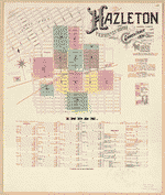
 Sanborn Fire Insurance Map from Hazleton, Luzerne County, Pennsylvania.
Site:
American Memory-cultural
Original Format:
Map
Date:
1884-01-01
Sanborn Fire Insurance Map from Hazleton, Luzerne County, Pennsylvania.
Site:
American Memory-cultural
Original Format:
Map
Date:
1884-01-01
-
 Sanborn Fire Insurance Map from Hazleton, Luzerne County, Pennsylvania.
Site:
American Memory-cultural
Original Format:
Map
Date:
1891-01-01
Sanborn Fire Insurance Map from Hazleton, Luzerne County, Pennsylvania.
Site:
American Memory-cultural
Original Format:
Map
Date:
1891-01-01
-
 Sanborn Fire Insurance Map from Hazleton, Luzerne County, Pennsylvania.
Site:
American Memory-cultural
Original Format:
Map
Date:
1895-01-01
Sanborn Fire Insurance Map from Hazleton, Luzerne County, Pennsylvania.
Site:
American Memory-cultural
Original Format:
Map
Date:
1895-01-01
-
 Sanborn Fire Insurance Map from Hazleton, Luzerne County, Pennsylvania.
Site:
American Memory-cultural
Original Format:
Map
Date:
1900-01-01
Sanborn Fire Insurance Map from Hazleton, Luzerne County, Pennsylvania.
Site:
American Memory-cultural
Original Format:
Map
Date:
1900-01-01
-
 Sanborn Fire Insurance Map from Hazleton, Luzerne County, Pennsylvania.
Site:
American Memory-cultural
Original Format:
Map
Date:
1905-01-01
Sanborn Fire Insurance Map from Hazleton, Luzerne County, Pennsylvania.
Site:
American Memory-cultural
Original Format:
Map
Date:
1905-01-01
-
 Map of Butler County, Pennsylvania /
Contributor:
Dunlap, Jas
Site:
American Memory-cultural, Main Catalog
Original Format:
Map
Date:
1858
View catalog record
Map of Butler County, Pennsylvania /
Contributor:
Dunlap, Jas
Site:
American Memory-cultural, Main Catalog
Original Format:
Map
Date:
1858
View catalog record
-
 Map of Northumberland County, Pennsylvania : from actual surveys by G.M. Hopkins, Jr., Civil Engineer /
Contributor:
Hopkins, Griffith Morgan
Site:
American Memory-cultural, Main Catalog
Original Format:
Map
Date:
1858
View catalog record
Map of Northumberland County, Pennsylvania : from actual surveys by G.M. Hopkins, Jr., Civil Engineer /
Contributor:
Hopkins, Griffith Morgan
Site:
American Memory-cultural, Main Catalog
Original Format:
Map
Date:
1858
View catalog record
-
 Map of Forest Co., Pennsylvania /
Contributor:
Irwin, R.
Site:
American Memory-cultural, Main Catalog
Original Format:
Map
Date:
1881
View catalog record
Map of Forest Co., Pennsylvania /
Contributor:
Irwin, R.
Site:
American Memory-cultural, Main Catalog
Original Format:
Map
Date:
1881
View catalog record
-
 A map of Wayne & Pike counties, Pennsylvania : showing the situations & forms of the warrantee tracts, with the numbers by which the respective ...
Contributor:
Torrey, Jason
Site:
American Memory-cultural, Main Catalog
Original Format:
Map
Date:
1814
View catalog record
A map of Wayne & Pike counties, Pennsylvania : showing the situations & forms of the warrantee tracts, with the numbers by which the respective ...
Contributor:
Torrey, Jason
Site:
American Memory-cultural, Main Catalog
Original Format:
Map
Date:
1814
View catalog record
You might also like
-

 Prominent men; Scranton and vicinity,
Contributor:
Stoddard, Dwight J[ames]
Site:
Main Catalog
Original Format:
Book
Date:
1906
Prominent men; Scranton and vicinity,
Contributor:
Stoddard, Dwight J[ames]
Site:
Main Catalog
Original Format:
Book
Date:
1906
-
Contributions to the history of the Lackawanna Valley /
Contributor:
Hollister, H.
Site:
Main Catalog
Original Format:
Book
Date:
1857
-
History of the Lackawanna Valley /
Contributor:
Hollister, H.
Site:
Main Catalog
Original Format:
Book
Date:
1885
-
History of the Lackawanna Valley
Contributor:
Hollister, H.
Site:
Main Catalog
Original Format:
Book
Date:
1903
-
The flight from Wyoming.
Contributor:
Wilcox, William A.
Site:
Main Catalog
Original Format:
Book
Date:
1900
-
History and directory of Newton and Ransom townships, Lackawanna County, Pennsylvania;
Contributor:
Stephens, J. Benjamin
Site:
Main Catalog
Original Format:
Book
Date:
1912