
Colorado Water Science Center
Home
Welcome to the USGS Colorado Water Science Center! Please use these pages to explore the hydrologic data and scientific investigations we conduct on Colorado water resources.
Current Water Conditions

Explore real-time Colorado streamflow, groundwater, and water-quality conditions.
Current ConditionsScience Highlight
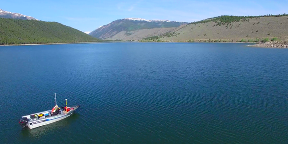
To better characterize the water supply capacity of Clear Creek Reservoir, a bathymetry survey was conducted. The methods used allowed water-resource managers to maintain typical reservoir operations and eliminate the need to empty the reservoir.
Learn moreNews

Bakken Shale unconventional oil and gas production has not caused widespread hydrocarbon contamination to date in groundwater used for water supply
A new USGS study reports that shale-oil and -gas production from a major production area in Montana, North Dakota, and South Dakota has not caused widespread hydrocarbon contamination to date in nearby aquifer zones used for drinking-water supply.

USGS Unveils Mobile Flood Tool for the Nation
The U.S. Geological Survey announced Friday the completion of a new mobile tool that provides real-time information on water levels, weather and flood forecasts all in one place on a computer, smartphone or other mobile device.

USGS Responds to Spring Flooding
U.S. Geological Survey field crews are measuring flooding across the country as spring weather is in full swing. Warming temperatures, increased precipitation and snowmelt have caused moderate to major flooding in the upper Midwest, East Coast, Central Plains and the Southeast portions of the country.
Publications

Geochemistry and age of groundwater in the Williston Basin, USA: Assessing potential effects of shale-oil production on groundwater quality
Thirty water wells were sampled in 2018 to understand the geochemistry and age of groundwater in the Williston Basin and assess potential effects of shale-oil production from the Three Forks-Bakken petroleum system (TBPS) on groundwater quality. Two geochemical groups are identified using hierarchical cluster analysis. Group 1 represents the...
McMahon, Peter B.; Galloway, Joel M.; Hunt, Andrew; Belitz, Kenneth; Jurgens, Bryant; Johnson, Tyler D. Spatial variability in seasonal snowpack trends across the Rio Grande headwaters (1984 - 2017)
This study evaluated the spatial variability of trends in simulated snowpack properties across the Rio Grande headwaters of Colorado using the SnowModel snow evolution modeling system. SnowModel simulations were performed using a grid resolution of 100 m and 3-hourly time step over a 34-yr period (1984–2017). Atmospheric forcing was provided by...
Sexstone, Graham A.; Penn, Colin A.; Liston, Glen; Gleason, Kelly; Moeser, C. David; Clow, David W. QCam: sUAS-based doppler rdar for measuring river discharge
The U.S. Geological Survey is actively investigating remote sensing of surface velocity and river discharge (discharge) from satellite-, high altitude-, small, unmanned aircraft systems- (sUAS or drone), and permanent (fixed) deployments. This initiative is important in ungaged basins and river reaches that lack the infrastructure to deploy...
Fulton, John W.; Anderson, Isaac E.; Chiu, C.-L.; Sommer, Wolfram; Adams, Josip; Moramarco, Tommaso; Bjerklie, David M.; Fulford, Janice M.; Sloan, Jeff L.; Best, Heather; Conaway, Jeffrey S.; Kang, Michelle J.; Kohn, Michael S.; Nicotra, Matthew J.; Pulli, Jeremy J.