
Nebraska Water Science Center
Home
Our Nebraska Water Science Center priority is to continue the important work of the Department of the Interior and the USGS, while also maintaining the health and safety of our employees and community. Based on guidance from the White House, the CDC, and state and local authorities, we are shifting our operations to a virtual mode and have minimal staffing within our offices.
Current Water Conditions
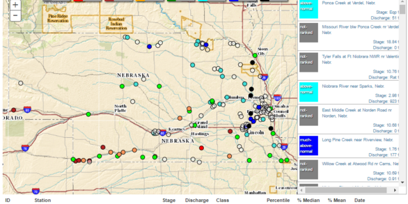
See real-time Nebraska streamflow, groundwater, and water-quality conditions and historical data from our water dashboard.
View the dashboardScience Highlights

Leading, innovating, and excelling in hydrologic monitoring, investigations, research, and data delivery for Nebraska.
Find out howQuick Links
See some of our most popular links.
Missouri River Water Information Portal
Check out our dataNews

USGS Unveils Mobile Flood Tool for the Nation
The U.S. Geological Survey announced Friday the completion of a new mobile tool that provides real-time information on water levels, weather and flood forecasts all in one place on a computer, smartphone or other mobile device.

Media Advisory: USGS Measures Record Flooding Across Nebraska
Reporters: Do you want to accompany a USGS field crew as they measure flood impacts? Please contact Marisa Lubeck or Jason Lambrecht to coordinate.

Reservoir Sediment Can be Used as Fracking Proppant
Instead of requiring costly dredging to remove sediment buildup behind water reservoirs and diversions, sediment from reservoirs in the Missouri River Basin could actually be used as fracking proppant feedstock, also known as frac sand, according to a recently published U.S. Geological Survey study.
Publications
Interpretation of hydrogeologic data to support groundwater management, Bazile Groundwater Management Area, northeast Nebraska, 2019—A case demonstration of the Nebraska Geocloud
Nitrate, age tracer, and continuous groundwater-level data were interpreted in conjunction with airborne electromagnetic (AEM) survey data to understand the movement of nitrate within the Bazile Groundwater Management Area (BGMA) in northeastern Nebraska. Previously published age tracer data and nitrate data indicated vertical stratification of...
Hobza, Christopher M.; Steele, Gregory V.
Modeling Escherichia coli in the Missouri River near Omaha, Nebraska, 2012–16
The city of Omaha, Nebraska, has a combined sewer system in some areas of the city. In Omaha, Nebr., a moderate amount of rainfall will lead to the combination of stormwater and untreated sewage or wastewater being discharged directly into the Missouri River and Papillion Creek and is called a combined sewer overflow (CSO) event. In 2009, the city...
Densmore, Brenda K.; Hall, Brent M.; Moser, Matthew T.
Altitude of the potentiometric surface in the Mississippi River Valley alluvial aquifer, spring 2018
A potentiometric-surface map for spring 2018 was created for the Mississippi River Valley alluvial (MRVA) aquifer using available groundwater-altitude data from 1,126 wells completed in the MRVA aquifer and from the altitude of the top of the water surface in area rivers from 66 streamgages. Personnel from Arkansas Natural Resources Commission,...
McGuire, Virginia L.; Seanor, Ronald C.; Asquith, William H.; Nottmeier, Anna M.; Smith, David C.; Tollett, Roland W.; Kress, Wade H.; Strauch, Kellan R.