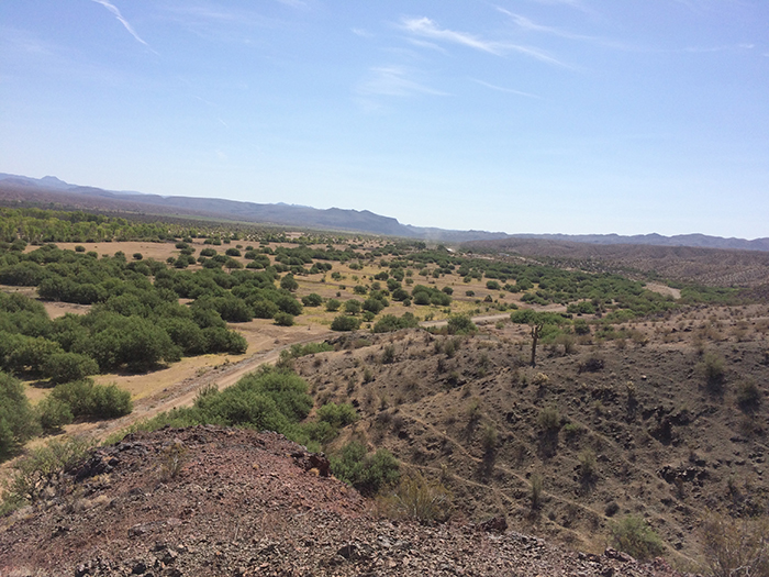
Planet Ranch Conservation Area
Located along the Bill Williams River, adjacent to the east side of the Bill Williams River National Wildlife Refuge

- DESCRIPTION
- LOCATION
- SPECIES USE
- ACTIVITIES
- MULTIMEDIA
In 2008, the Lower Colorado River Multi Species Conservation Program (LCR MSCP) Steering Committee approved a land and water resolution, which authorized Reclamation to enter into negotiations with the Byner cattle company (a subsidiary of Freeport McMoRan) to lease the property and to maintain a 5,549 acre-feet of water entitlement to be used as the Planet Ranch Conservation Area (PRCA). The water resolution was determined through the Federal appraisal process and the property was subsequently donated to the State of Arizona. The property is now managed by the Arizona Game and Fish Department (AZGFD) and encompasses approximately 3,418 acres of land, of which approximately 2,400 acres had been farmed by previous landowners to produce alfalfa crop.
The intent of this acquisition from Freeport McMoRan was to secure the river corridor as a conservation area and to achieve (1) active restoration within the property boundary, (2) passive restoration within the active Bill Williams River channel on the property, and (3) downstream credit on the Bill Williams River National Wildlife Refuge. Under the guidance of the LCR MSCP’s Habitat Conservation Plan (HCP), the program is tasked with creating 360 acres of actively managed backwater habitat to support the native fish augmentation program. Backwater habitats include those that are either connected or disconnected to the Colorado River. As partial fulfillment of the LCR MSCP’s backwater acreage goals in the State of Arizona, the PRCA would consist of approximately 71 acres of disconnected backwater refugia ponds for native fish.
The ponds would primarily be used to support two endangered native fish species, namely the razorback sucker (Xyrauchen texanus) and the bonytail chub (Gila elegans). The ponds would also be integrated into an existing mosaic of cottonwood-willow along the Bill Williams River and upland honey mesquite. Excess water flows from the ponds will be directed into areas where infiltration will occur naturally on undisturbed ground where possible, or to systems of swales and detention basins, which will also allow for water to infiltrate to the sub-surface. Both of these methods will enhance the recruitment and distribution of the cottonwood-willow species and other native plants in the area. In addition, the refugia ponds will support mostly cattails and bulrush around their edges.
In order for the LCR MSCP to secure the water rights of the property, a contract farmer was utilized in 2016 and again in 2017 to grow and irrigate approximately 1,200 acres of alfalfa pasture on the farm fields in the northeastern area of the property, which is also east of the main north-south access road that bisects the property. Once the farmer is done irrigating the alfalfa and construction activities can begin, most of the excavated soil material from the backwater pond areas will be placed in the pond areas as much as possible. Excess material would be placed in the farm fields and stabilized.
The property is accessible by the public through two main entrances. One is on the north side and another on the south side. Allowable land use activities at the PRCA are limited and the following is prohibited:
- ATVs or off-road vehicles
- Camping
- Fires or wood gathering
- Hunting
The public is encouraged to stay on the main road that connects the north and south entrances and not interfere with the PRCA and its backwater ponds. The entire PRCA is considered an active restoration area and any access to these areas, outside of the main road corridor, is allowed only on foot. Activities done on foot, such as birding or hiking, are considered acceptable uses of the PRCA by the public.
A fact sheet for this Conservation Area can be found here. Technical Reports for this Conservation Area can be found here.
Updated January 7, 2020
Planet Ranch Conservation Area is located within Reach 4 in Arizona, east of river mile 190 along the Bill Williams River. It is also adjacent to the east side of Bill Williams River National Wildlife Refuge, which is approximately 20 miles northeast of Parker, AZ.
For specific information on the Conservation Area, please contact Terry Murphy, Restoration Group Manager, at (702) 293-8140 or via email at tmurphy@usbr.gov.
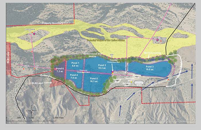
This map shows the acreage for this area. You can click on the map for a larger view.

Each Conservation Area targets certain LCR MSCP covered and evaluation species habitats. Below, on the left, is a list of the LCR MSCP species in which habitat will be targeted for creation for this particular conservation area. To the right is a list of LCR MSCP species that, through monitoring, have been found utilizing the conservation area.
| Targeted LCR MSCP Species | LCR MSCP Species Utilizing Site |
| Native Fish | Native Fish |
| Bonytail | |
| Razorback sucker | |
| Riparian Obligates | Riparian Obligates |
| Arizona Bell's Vireo | Arizona Bell's Vireo (breeding) |
| Elf Owl | |
| Gilded Flicker | |
| Gila Woodpecker | Gila Woodpecker (breeding) |
| Sonoran Yellow Warbler | Sonoran Yellow Warbler (breeding) |
| Southwestern Willow Flycatcher | |
| Summer Tanager | Summer Tanager (breeding) |
| Vermilion Flycatcher | Vermilion Flycatcher (breeding) |
| Yellow-Billed Cuckoo | Yellow-Billed Cuckoo |
| Marsh Birds | Marsh Birds |
| California Black Rail | |
| Western Least Bittern | Western Least Bittern |
| Yuma Clapper Rail | |
| Bats, Small Mammals, and Insects | Bats, Small Mammals, and Insects |
| California Leaf-Nosed Bat (foraging) | |
| Colorado River Cotton Rat | |
| MacNeill's Sootywing Skipper | |
| Pale Townsend's Big-Eared Bat (foraging) | |
| Western Red Bat | Western Red Bat (foraging/roosting) |
| Western Yellow Bat | Western Yellow Bat (foraging/roosting) |
Bird Monitoring
Surveys for covered bird species are planned to occur on a pre-development and post-development basis to evaluate whether covered species inhabit the site. If covered species are found inhabiting the site post-development, it is likely that an annual bird monitoring/survey schedule will be established.
The cottonwood-willow and honey mesquite land cover types would be surveyed for neotropical birds during the breeding season (April – June).
Southwestern willow flycatcher (Empidonax trailli extimus) surveys would be conducted in areas of suitable habitat (cottonwood-willow) during their breeding season (May – August). Yellow-billed cuckoo (Coccyzus americanus occidentalis) surveys would be conducted in areas of suitable habitat (cottonwood-willow) during their breeding season (June – September). Surveys would also be conducted according to a standardized protocol. If breeding or resident birds are detected, they may be captured and banded and nests may be monitored for success.
The marsh portions of the backwaters and irrigation conveyance structures may be surveyed for marsh birds prior to maintenance activities following the North American Marsh Bird Survey Protocol (Conway 2011).
Marsh bird surveys may be conducted once the ponds are created if suitable habitat is detected.
Mammal Monitoring
No mammal trapping activities are planned for the PRCA.Reptile Monitoring
Northern Mexican garter snake surveys may be conducted prior to maintenance or construction activities to move animals out of harm’s way.
Fish Monitoring
Once the ponds are built and stocked with fish, a sampling protocol will be established that would allow for statistical accuracy and long-term database development. The primary objectives for monitoring of the fish include: 1) to document persistence and health of adult populations for MSCP backwater credit, and 2) document reproduction and recruitment to inform long term management of the ponds.
The primary means for documenting the persistence and health of adult populations will be accomplished using remote PIT tag scanning and annual fall surveys. Multiple permanent remote passive integrated responder (PIT) scanning stations will be deployed in each pond. Data from these units will be used to monitor the pond populations throughout the year.
Two surveys per year are anticipated. Once in the fall and once in the spring. Fall surveys will be the primary means for capturing new adult fish to be PIT tagged. Spring monitoring will occur monthly from January through May with the primary focus of targeting larvae and young of year. All fish captured will be measured for total length in millimeters, weighed in grams, and (adult fish) would be tagged with a 134.2 kHz PIT tag.
Acreage Map
This map shows the acreage for this area. You can click on the map for a larger view.
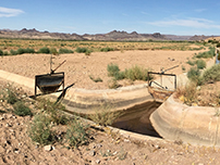
This gallery includes photos of this conservation area. If you require larger photos, please contact our webmaster Michelle Reilly at mreilly@usbr.gov.