

Metadata
Metadata / Directory File Header Information
-
Download using a secure
FTP client, such as FileZilla
Hurricane Epsilon Drifter Deployments
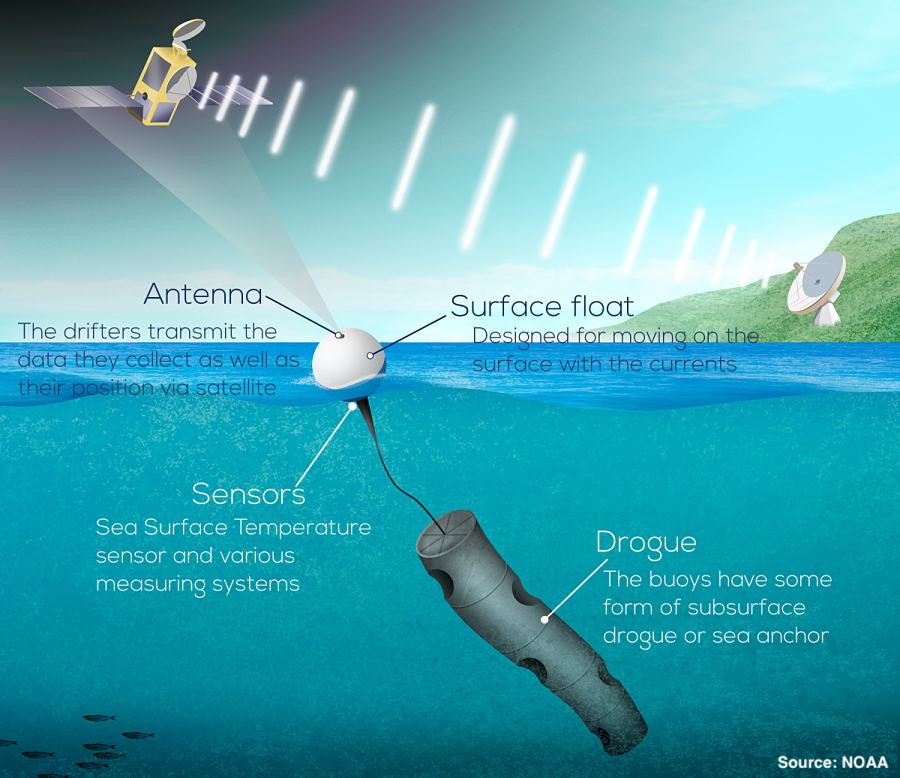
On the afternoon of Thursday, Oct. 22, a C-130J of the Air Force 53rd squadron “Hurricane Hunters” deployed 12 drifters ahead of Hurricane Epsilon northeast of Bermuda. This deployment was coordinated by Rick Lumpkin (NOAA/AOML), in partnership with Luca Centurioni (SIO/LDL), CARCAH (NWS/NHC), and colleagues in HRD, EMC, and elsewhere. The drifters, designed and built at the Lagrangian Drifter Laboratory at SIO, are measuring directional wave spectra, wind speed and direction, barometric pressure, sea temperatures from the surface to 150m depth, and near-surface ocean currents. All 12 drifters are now transmitting data being placed on the GTS. The data will be analyzed as a case study of a hurricane transitioning to extratropical status, with an unusually large gale-force wind field.

Location of 6 pairs of drifters deployed ahead of Hurricane Epsilon, superimposed on Sea Surface Temperature (colors). Each pair had a wave drifter and either a Minimet (a standard GDP barometer drifter with wind speed and direction added) or ADOS drifter (replacing the 15m drogue with a thermistor chain to 150m depth).
Hurricane Teddy Drifter Deployments

Location of 8 pairs of drifters deployed ahead of Hurricane Teddy, superimposed on Sea Surface Temperature (colors). Each pair had a wave drifter and either a Minimet (a standard GDP barometer drifter with wind speed and direction added) or ADOS drifter (replacing the 15m drogue with a thermistor chain to 150m depth).
On Saturday, September 19, 16 drifters were air-deployed from an Air Force C-130J of the 53rd Reconnaissance Squadron ahead of major hurricane Teddy southeast of Bermuda. The deployment was coordinated by Rick Lumpkin (NOAA/AOML) in collaboration with Luca Centurioni (SIO/LDL), CARCAH (NWS/NHC), and colleagues in EMC, HRD, and elsewhere. The drifters, designed and built at the Lagrangian Drifter Laboratory at SIO, are measuring directional wave spectra, wind speed and direction, barometric pressure, sea temperatures from the surface to 150m depth, and near-surface ocean currents. The drifters were packaged two per box; the parachute on one box failed, but all other drifters reported good data as the storm approached and passed, including measurements within the cold wake of Hurricane Paulette that had passed over the region the week before.
Hurricane Isaias Drifter Deployments
Late on Sunday, August 2, an Air Force C-130J of the 53rd Reconnaissance Squadron “Hurricane Hunters” deployed eight drifters ahead of tropical cyclone Isaias off the Carolina coast. These deployments were coordinated by Rick Lumpkin of NOAA/AOML, working with NWS/NHC/CARCAH and Scripps Institution of Oceanography (SIO). The drifters, designed and built at SIO and funded by NOAA/GOMO, measure barometric pressure, sea surface temperature, ocean currents, wind speed and direction, and directional wave spectra. The data are now going onto the Global Telecommunications System for operational use by the National Weather Service and for better understanding how strong winds interact with the Gulf Stream system during wave formation and air-sea interactions. Isaias is forecast to reach Category 1 strength before reaching the array and subsequently making landfall.
New, NetCDF versions of all the 6-hour quality-controlled data are now available at the OSMC Interpolated Data ERDDAP server and at ftp://ftp.aoml.noaa.gov/phod/pub/lumpkin/netcdf/ (using a secure FTP client, such as FileZilla). These now include a large amount of additional metadata including deploying country, drogue cross-sectional area, surface buoy diameter, presence of subsurface float, starting voltage, and much more. For instructions on how to download the data, follow these Interpolated Data Request Instructions and enter the parameters of interest.
The Global Drifter Program now has a digital object identifier (doi) to reference publications incorporating quality-controlled 6-hour interpolated data from ocean surface drifting buoys. To view specifics pertaining to this doi, or to reference drifter data in your publication, please utilize https://doi.org/10.25921/7ntx-z961.
Version 1.03 of the hourly drifter data is now available (using a secure FTP client, such as FileZilla).
Study Improves Drifter-Based Estimates of Near-Surface Ocean Currents
Using 40 years of observations from the NOAA''s Global Drifter Program Array, the authors depict the annual mean speed of ocean currents at 15 meters depth. The vectors highlight the general direction of the large-scale circulation. Image provided by Lucas Laurindo, University of Miami Rosenstiel School of Marine and Atmospheric Science.