
- 12201 Sunrise Valley Drive
- Reston, VA 20192, USA
- 703-648-5953
- 1-888-ASK-USGS
- Employee Directory
- Web Chat
The Alaska Region represents a resource-rich, dynamic landscape shaped by volcanoes, earthquakes, major rivers, and glaciers. Here, we conduct research to inform management of Alaska’s extensive natural resources, inform national Arctic energy policy, and provide scientific information to help others understand, respond to, and mitigate impacts from natural hazards.
View Centers and Observatories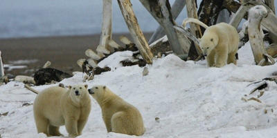
The rapid changes encountered in the Arctic region from climate change require reliable scientific research and up-to-date information to inform resource policy and decisions.
Read more...
The portal is a searchable, web map-based tool to facilitate public and partner access to information on over 200 subjects under USGS study in the Nation’s largest State. The Alaska Science Portal can be found here http://alaska.usgs.gov/portal/
Go to the Portal
A new digital geologic map of Alaska provides land users, managers and scientists geologic information for the evaluation of land use in relation to resource extraction, conservation, natural hazards and recreation.
Read more…
Water users around the country can now view the past and simulated future of hydrologic processes.

Caribou, North America’s wild reindeer, have lives apart from their famous role on Christmas Eve. Reindeer and caribou are large, cold-adapted, herding herbivores related to deer, elk and moose.
To learn more about how these arctic antler-bearers spend the other 364 days of the year, we talked to USGS caribou expert Dr. Layne Adams, who has studied these animals for more than 30 years.

The marine fishes in waters of the United States north of the Bering Strait have received new and increased scientific attention over the past decade (2005–15) in conjunction with frontier qualities of the region and societal concerns about the effects of Arctic climate change. Commercial fisheries are negligible in the Chukchi and Beaufort Seas,...
The Coastal Expert Workshop, which took place in Ottawa, Canada from March 1 to 3, 2016, initiated the development of the Arctic Coastal Biodiversity Monitoring Plan (Coastal Plan). Meeting participants, including northern residents, representatives from industry, non-governmental organisations (NGOs), academia, and government regulators and...

The United States is one of eight Arctic nations responsible for the stewardship of a polar region undergoing dramatic environmental, social, and economic changes. Although warming and cooling cycles have occurred over millennia in the Arctic region, the current warming trend is unlike anything recorded previously and is affecting the region...
Several Research areas are listed and their contacts regarding Glacial Aquifer System Groundwater Availability Study are available here.
<- Back to main Glacial Aquifer System Groundwater...
The Molecular Ecology Laboratory applies genetic and genomic technologies to address a variety of complex questions and conservation issues facing the management of the Nation's fish and wildlife resources. Together with our partners, we design and implement studies to document genetic diversity and the distribution of genetic variation among individuals, populations, and species....
The Alaska Mapping Executive Committee (AMEC) meets regularly to coordinate on critical Alaska topographic mapping activities. Executives from 15 Federal agencies and the State of Alaska are combining efforts to acquire new digital elevation, hydrography, transportation, shoreline and geopositional data for Alaska, and create a new digital topographic map series for the State.
The Alaska Mapping Initiative is a U.S. Geological Survey effort to generate new topographic maps of Alaska. The USGS is coordinating with the State of Alaska and multiple Federal agencies to acquire updated digital map layers such as elevation, surface water, roads, and boundaries, and to create a modern series of digital maps for Alaska using these updated layers.
Scientists perform a range of studies that document, assess, and model coastal change, risk, and vulnerability. Studies include historical shoreline change, the geologic structure and history of coastal regions, sediment supply and transport, sea-level rise, and how extreme storm events affect rates and impacts of coastal change.
We study the distribution and hazard potential of coastal and submarine events such as earthquakes and submarine landslides and associated tsunami potential, hurricane induced coastal inundation, extreme storms, sea-level rise and oil and gas spills. We also model development to help evaluate and forecast coastal hazard probability and occurrence.
Our scientists conduct research studies focused on geologic mapping, sampling and understanding of mineral and energy resources and studies of the geologic setting and processes to inform renewable energy development offshore.
We bring together multidisciplinary expertise focused on developing tools and models to improve understanding of how healthy ecosystems function as well as how they respond to environmental changes and human impacts including ecosystem restoration. Research studies address coral reef, coastal wetland, benthic habitat and groundwater resources.
The Volcano Hazards Program develops long-range volcano hazards assessments. These includes a summary of the specific hazards, their impact areas, and a map showing ground-hazard zones. The assessments are also critical for planning long-term land-use and effective emergency-response measures, especially when a volcano begins to show signs of unrest.
The Alaska region oversees five volcano observatories located across the Western U.S. Each has a unique role to help emergency responders and the public prepare and respond to volcanic hazards such as ash, lava, and lahars.
This program responds to volcanic crises worldwide. Upon request of host countries, a team of scientists can rapidly respond to reduce fatalities and economic losses. Our scientists also work with international partners to improve monitoring and understanding of volcanic hazards.
These natural hazards are significant areas of concern as they threaten the lives of people and/or cause economic damage to Alaska villages along rivers and coast. Research activities move forward innovative means to monitor these hazards and conduct research on the underlying physical processes to improve short and long-term hazard assessments.

Radar data is being collected statewide for Alaska under direction of the USGS 3D Elevation Program (3DEP). The new data is vastly improving the accuracy and resolution of elevation data for the state, and is being collected using an airborne Interferometric Synthetic Aperture Radar (IfSAR) sensor. USGS and the State of Alaska maintain web-based status maps and download services.

The 3DEP products and services available through The National Map consist of lidar point clouds (LPC), standard digital elevation models (DEMs) at various horizontal resolutions, elevation source and associated datasets, an elevation point query service and bulk point query service. All 3DEP products are available, free of charge and without use restrictions.

Many volcanoes in the U.S. are monitored by arrays of several instruments that detect subtle movements within the earth and changes in gas and water chemistry. The Volcano Hazards Program streams this data to its Volcano Observatories and makes it available on volcano-specific websites.

This is a new tool for understanding and communicating risks. The activities include the development of risk models and approaches to improve the situational awareness of communities and industries to natural hazards and reduce the uncertainty of those risk assessments.

Reports of ash fall are important to us; we use your observations to assess the character and size of an eruption plume. We report these data to the National Weather Service so they can keep their Ashfall Advisories current. Additionally, reports of NO ashfall during an eruption with expected ashfall are also important to us.

Consistent synthesis, integration, storage, and availability of fundamental data is critical to meeting the needs of USGS Science. We develop databases for hydrography, topography, invasive species, water resources, and many other datasets utilized by resource managers.
The 3DEP products and services available through The National Map consist of standard digital elevation models (DEMs) at various horizontal resolutions, elevation source and associated datasets, an elevation point query service and bulk point query service. All 3DEP products are available, free of charge and without use restrictions.

New US Topo maps for Alaska are being produced statewide, with digital 7.5 minute 1:25,000-scale maps providing a comprehensive update to the 15-minute 1:63,360-scale printed maps produced nearly fifty years ago. You can view a status map showing where the new maps are available, and link to a site to download the maps.

This portal is a “go to” source for maps related to ocean and coastal mapping. Information is organized by geography or region, by theme, and by the year data was published.
The United States is one of eight Arctic nations responsible for the stewardship of a polar region undergoing dramatic environmental, social, and economic changes. Although warming and cooling cycles have occurred over millennia in the Arctic region, the current warming trend is unlike anything recorded previously and is affecting the region...
Shasby, Mark; Smith, DurelleThe marine fishes in waters of the United States north of the Bering Strait have received new and increased scientific attention over the past decade (2005–15) in conjunction with frontier qualities of the region and societal concerns about the effects of Arctic climate change. Commercial fisheries are negligible in the Chukchi and Beaufort Seas,...
The Coastal Expert Workshop, which took place in Ottawa, Canada from March 1 to 3, 2016, initiated the development of the Arctic Coastal Biodiversity Monitoring Plan (Coastal Plan). Meeting participants, including northern residents, representatives from industry, non-governmental organisations (NGOs), academia, and government regulators and...
Anderson, Rebecca D.; McLennan, Donald; Thomson, Laura; Wegeberg, Susse; Pettersvik Arvnes, Maria; Sergienko, Liudmila; Behe, Carolina; Moss-Davies, Pitseolak; Fritz, Stacey; Christensen, Thomas K.; Price, Courtney


Water users around the country can now view the past and simulated future of hydrologic processes.
Caribou, North America’s wild reindeer, have lives apart from their famous role on Christmas Eve. Reindeer and caribou are large, cold-adapted, herding herbivores related to deer, elk and moose.
To learn more about how these arctic antler-bearers spend the other 364 days of the year, we talked to USGS caribou expert Dr. Layne Adams, who has studied these animals for more than 30 years.


ANCHORAGE, Alaska — This year marks the 50th anniversary of one of the longest continuous glacier research efforts in North America.

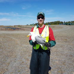
ANCHORAGE, Alaska — Some gulls in southcentral Alaska are carriers of antibiotic resistant strains of E. coli, according to a new study co-authored by the U.S. Geological Survey.

New research from the U.S. Geological Survey and partners illustrates how climate change is perceived among different generations of indigenous residents in subarctic Alaska. While all subjects agreed climate change is occurring, the older participants observed more overall changes than the younger demographic.

Two snapshots from Landsat show the extent of a landslide in an Alaska National Park.

A team of USGS scientists spent 10 days in the wilderness, exploring one of the fastest-moving faults in America

Information relating to fish biology, locations and effects of climate change will help guide future research and management decisions

MEDIA ADVISORY
Twenty middle-school girls from Washington and Oregon are participating in the second annual “GeoGirls” outdoor volcano science program at Mount St. Helens, jointly organized by the U.S. Geological Survey and the Mount St. Helens Institute.

Information will aid marine and conservation planning

A new geologic map of the Long Valley Caldera, Mammoth Mountain, and the Middle Fork canyon of the San Joaquin River including Devils Postpile National Monument, recounts the geologic and volcanic history of the area east of the Sierra Nevada in far greater detail than any previously published report.

Phone: (907) 786-7000
Fax: (907) 786-7020

askHVO@usgs.gov
Phone: 808-967-7328
vhpweb@usgs.gov
Phone: 650-329-5083

http://www.avo.alaska.edu/contact.php
Phone: 907-786-7497

vhpweb@usgs.gov
Phone: 360-993-8900
Fax: 360-993-8980

yvowebteam@usgs.gov
Phone: 650-329-5083


