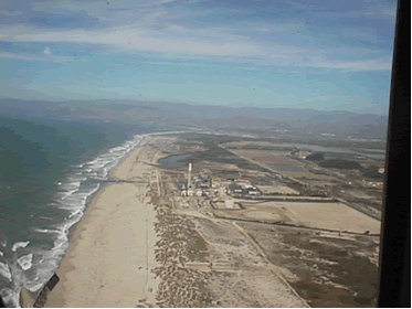
Help promote Energy Explained with the outreach toolkit

Offshore Oil and Gas

What is offshore?

Image of a coastline
image of coastline from above

Source: Stock photography (copyrighted)

Map showing Exclusive Economic Zone around the United States and Territories
Map showing Exclusive Economic Zone around United States and territories.
Click to enlarge »

Source: National Energy Education Development Project (public domain)

Diagram of shore and ocean overlaid with territorial sea, Exclusive Economic Zone, the Continental Shelf, and Continental Slope
diagram of land and ocean overlayed with 3 miles of territorial sea, 200 miles of Exclusive Economic Zone, the Continental Shelf, and Continetal Slope.
Click to enlarge »

Source: National Energy Education Development Project (public domain)

When someone stands at an ocean beach, they are not at the very edge of the United States.

Although it might seem like the ocean is the nation's border, the border is actually 200 miles away from the land. This area around the country is called the Exclusive Economic Zone (EEZ).

In 1983, U.S. President Ronald Reagan claimed the EEZ in the name of the United States. In 1994, all countries were granted an EEZ of 200 miles from their coastline according to the International Law of the Sea.

The ocean floor extends from the beach into the ocean on a continental shelf that gradually descends to a sharp drop, called the continental slope. The width of the U.S. continental shelf varies from 10 miles to 250 miles (16 kilometers to 400 kilometers). The water on the continental shelf is relatively shallow, rarely more than 500 feet to 650 feet (150 meters to 200 meters) deep.

The continental shelf drops off at the continental slope, ending in abyssal plains that are 2 miles to 3 miles (3 kilometers to 5 kilometers) below sea level. Many of the plains are flat, while others have jagged mountain ridges, deep canyons, and valleys. The tops of some of these mountain ridges form islands where they extend above the water.

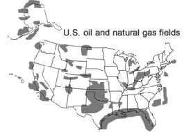
Several federal government agencies manage the natural resources in the EEZ. The U.S. Department of Interior's Bureau of Ocean Energy Management and the Bureau of Safety and Environmental Enforcement manage the development of offshore energy resources by private companies. These companies lease areas for energy development and pay the federal government royalties on the energy resources they produce from the ocean. Individual states control the waters off their coasts out to 3 miles for most states and between 9 miles and 12 miles for Florida, Texas, and some other states.

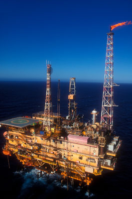
Most of the energy the United States gets from the ocean is oil and natural gas from wells drilled on the ocean floor. Other energy sources are also being developed offshore. Wind turbines are located offshore in several countries, and wind energy projects are being considered in several areas off the Atlantic coast of the United States. Wave energy, tidal energy, ocean thermal energy conversion, and methane hydrates are other energy sources currently being explored.

Last updated: January 7, 2016

Offshore drilling

Map of U.S. Oil and Gas Fields showing onshore and offshore fields. Source: National Energy Education Development Project

Source: National Energy Education Development Project (public domain)

Offshore oil rig
offshore oil rig

Source: Stock photography (copyrighted)

The border of the United States extends 200 miles beyond the coastline. The ocean area between the border and the coast is called the Exclusive Economic Zone (EEZ) and includes areas administered by state governments and the federal government. Thirty basins in the EEZ have been identified as containing oil and natural gas reserves.

The first offshore oil well was drilled in 1897 at the end of a wharf, 300 feet off the coast of Summerland, California. Early offshore drilling was in areas where the water was less than 300 feet deep. Oil and natural gas drilling rigs now operate in water as deep as two miles.

Floating platforms are used for drilling in deeper waters. These self-propelled vessels are attached to the ocean floor using large cables and anchors. After wells have been drilled from these platforms, production equipment is lowered to the ocean floor. Wells have been drilled in water depths of 10,000 feet or greater using floating rigs.

Some drilling platforms stand on stilt-like legs that are embedded in the ocean floor. These platforms not only hold all of the drilling equipment, but also the housing and storage areas for the work crews.

Offshore oil producers are required to take precautions to prevent pollution, spills, and significant changes to the ocean environment. Offshore rigs are designed to withstand hurricanes. Offshore production is much more expensive than onshore (land-based) production. When offshore oil wells are no longer productive enough to be economical, they are sealed and abandoned according to applicable regulations.

Nearly all offshore leasing and development activity currently occurs in the central and western Gulf of Mexico where thousands of platforms operate in waters up to 6,000 feet deep. A few platforms operate in depths of 10,000 feet or more. In 2015, offshore oil and natural gas production in the federal waters of the Gulf of Mexico accounted for about 16% of total U.S. crude oil production and about 4.5% of total U.S. dry natural gas production.

Last updated: January 17, 2017