North American Mesoscale Forecast System (NAM)

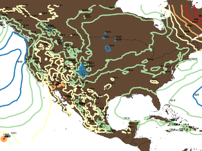
An animated image of NAM total surface 3-hourly precipitation, forecast from 03 UTC on July 10, 2012, to July 13, 2012, at 12 UTC. In the initial few frames, hurricane Emilia can be seen in the bottom left corner spinning off to the west. This image was produced with the Grid Analysis and Display System (GrADS) and ImageMagick.
More...
Product Types
NAM Analyses
| Model | Grid/Scale | Period of Record | Model Cycle | Output Timestep | Data Access Links |
|---|---|---|---|---|---|
| NAM-ANL | 218 (12km) - Domain | 03Mar2004–Present | 4/day: 00, 06, 12, 18UTC | +00, (+03, +06 precipitation fields) | Plot|FTP4u FTP HTTPS GDS TDS HAS |
NAM Forecasts
| Model | Grid/Scale | Period of Record | Model Cycle | Output Timestep | Data Access Links |
|---|---|---|---|---|---|
| NAM-NMM | 218 (12km) - Domain | 20Jun2006–Present | 4/day: 00, 06, 12, 18UTC | 3-hourly, +00 to +84 hours | Plot|FTP4u FTP HTTPS GDS TDS HAS |
| Meso-ETA | 218 (12km) - Domain | 15Feb2005–19Jun2006 | 4/day: 00, 06, 12, 18UTC | 3-hourly, +00 to +84 hours | Plot|FTP4u HAS |
| Meso-ETA | 218 (12km) - Domain | 01Mar2004–23Mar2005 | 4/day: 00, 06, 12, 18UTC | 3-hourly, +00 to +84 hours | Plot|FTP4u FTP HTTPS HAS |
| Meso-ETA | 215 (20km) - Domain | 02Jun2003–25May2005 | 4/day: 00, 06, 12, 18UTC | 3-hourly, +00 to +60 hours | FTP HTTPS |
| Meso-ETA | 212 (40km) - Domain | 02Jun2003–25May2005 | 4/day: 00, 06, 12, 18UTC | 3-hourly, +00 to +60 hours | FTP HTTPS |
| Meso-ETA | 211 (81km) - Domain | 02Jun2003–25May2005 | 2/day: 00, 12UTC | 6-hourly, +00 to +60 hours | FTP HTTPS |
| Early-ETA | 212 (40km) - Domain | 02Jun2003–25May2005 | 2/day: 00, 12UTC | 3-hourly, +00 to +60 hours | FTP HTTPS |
Data Usage Notes
July 2003: MSLET Missing for ETA 218 Forecast Hour 09
Messages from 09-hour forecast data for parameter MSLET in the ETA 218 grid are corrupt for all the cycles. We are unable to plot this data using GrADS or extract the data using GDS.
Also, the 09-hour forecast data for parameter MSLET in the ETA 218 grid is not being transmitted as a separate message. It is appended to the message for the forecast hour 03 data. It should arrive as bulletin ZPBE89*, but it arrives within bulletin ZPBB89*.
nomads3.ncdc.noaa.gov 54: wgrib -s ZPBB89_KWBE_20030710_0000
1:21:d=03071000:MSLET:MSL:3hr fcst:NAve=0
2:427172:d=03071000:MSLET:MSL:9hr fcst:NAve=0
Publication References
None
Miscellaneous Documentation
None
Links
GrADS PDEF files for the NOAAPort grids can be downloaded from our site. These files are needed for using locally downloaded copies of certain datasets in GrADS.
WMO Headers for NCEP AWIPS NAM Products made available to NOAAPORT


