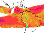
| Ensemble Tropical Rainfall Potential (eTRaP) | The eTRaP is a simple ensemble whose members are the 6-hourly totals from the single-orbit TRaPs. The eTRaP provides deterministic and probabilistic forecasts for each of four 6h time periods (e.g., 00-06h, 06-12h, 12-18h, 18-24h) as well as the 24 hour cumulative time period. Each eTRaP is made up of forecast using observations from potentially several microwave sensores--currently AMSU, SSMI and AMSRE--initiailized at several observation times, and possibly using several different track forecasts. An eTRaP will be produced, centered on the synoptic hours (e.g., 00Z, 06Z, 12Z, 18Z), from single-orbit TRaP segments with start times up to 3 hours after the synoptic hour. Product Link |
|
|
||
| POES | Resolution: 4 Km | Frequency: 6 Hours |
| Hydro-Estimator Rainfall | The Hydro-Estimator (HE) algorithm uses infrared (IR) brightness temperatures to identify regions of rainfall and retrieve rainfall rate, while using National Centers for Environmental Prediction (NCEP) Global Forecast System (GFS) model fields to account for the effects of moisture availability, evaporation, orographic modulation, and thermodynamic profile effects. Recently the HE has been extended to the entire globe equator-ward of 60 degrees to meet user community's need for support of global flash flood guidance efforts. The operational global HE products available include instantaneous rain rates and 1-hour, 3-hour, 6-hour, 24-hour and multi-day precipitation accumulations. Product Link |
|
|
||
| GOES | Resolution: 4 Km | Frequency: 15 min.; 1 hr. on AWIPS |
| Ice Water Path (MIRS & MSPPS) |
Ice Water Path is the integrated column amount of ice water in the cloud. It varies greatly from cloud to cloud and also depends on the cloud ice phase (cloud ice, hail, grauple, ice crystal). Cloud ice water plays an important role in the transport of energy (latent heat) in the earth-atmosphere system. The NESDIS operational IWP product is derived from AMSU-B/MHS 89 and 150 GHz channel measurements on board POES and Metop satellites, and is expressed in mm or kg/m2. The products are available at both pixel and grid levels. More information on MIRS Products More information on MSPPS Products |
|
|
||
| POES | Resolution: 16 km at Nadir | Frequency: Orbital and Daily |
| Operational NOAA Unique Megha-Tropiques Products | The Megha-Tropiques satellite was designed by the French (CNES) and Indian (ISRO) space agencies to study the water cycle and energy exchanges in the tropics. The NOAA Megha-Tropiques Data and Products System (MTRoPS) is developed to tailor Megha-Tropiques data, and also generate NOAA unique Level-2 science products to meet NOAA user requirements. The products provided (without MADRAS) include: tailored Megha-Tropiques SAPHIR brightness temperatures, rainfall rate, total precipitable water. The products are available in McIDAS and netCDF4 formats, depending on products specifics.
Product Link |
|
|
||
| Megha-Tropiques | ||
| Microwave Rain Rate (MSPPS) | Rainfall rate is a measure of the intensity of rainfall. It is measured by calculating the amount of rain that falls to the earth surface per unit area per unit of time. The NESDIS operational RR product is derived from 89 and 150 GHZs channel measurements of the Advanced Microwave Sounding Units (AMSU) -A & -B aboard on the NOAA POES satellites, and is expressed in mm/hr. The products are available at both pixel and grid levels. Product Link More information on MSPPS Products |
|
|
||
| POES | Resolution: 16 Km at Nadir | Frequency: Orbital (Granule) or Daily |
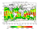
| Microwave Rain Rate (SSM/I, SSM/IS) |
This product shows the rainfall intensity (mm/hr) over the Earth's surface. It is derived from SSM/I channels 19V, 19H, 22V, 37V, and 85V on an orbital basis. Orbital and Mapped: SSM/I Product Link | SSM/IS Product Link |
|
|
||
| POES | Resolution: 15-50 Km | Frequency: Every 4 Hours |
| Precipitable Water Index | Product shows the amount of precipitable water derived from the difference between AVHRR channels 4 and 5. Precipitable water is defined as the total atmospheric water vapor contained in a vertical column of area extending between any two specified levels. This product is also known as the brightness temperature difference. Product Link |
|
|
||
| POES | Resolution: 15 Km | Frequency: Weekly |
| Satellite Precipitation Estimate Messages (SPENES) | Satellite-derived precipitation estimates (SPE’s) and satellite-based trend guidance are provided to the National Weather Service (NWS) when heavy convective rain threatens to produce flash flooding over the lower 48 states, Puerto Rico, and Hawaii. Support is also provided for heavy rain and snow associated with winter storms, and for heavy lake effect snow. This information is disseminated via Satellite Precipitation Estimate messages (SPENES), which are available on the Advanced Weather Interactive Processing System (AWIPS) and the Internet. “SPENES” is the AWIPS ID, and the WMO header for this message is “TXUS20 KNES”. In composing SPENES messages, the following data are used: GOES infrared (IR), visible (VIS), and water vapor (WV) imagery; GOES Sounder data and Derived Product Imagery (DPI); GOES satellite-derived winds; Microwave data from various Polar orbiting satellites; and surface and upper air data.
Product Link (Text with Graphics attached when available) |
|
|
||
| GOES and POES | Resolution: N/A | Frequency: Event Driven |
| Total Precipitable Water (ATOVS) | This product also known as Total Atmospheric Moisture (mm) with a 40 km resolution. It is derived from HIRS/3 channels 10-12 and is generated from the ATOVS processing system. Total precipitable water is defined as the vertically integrated water vapor in a column extending from the surface to the top of the atmosphere. Product Link |
|
|
||
| POES | Resolution: 45 Km | Frequency: Orbital |
| Total Precipitable Water (MSPPS) | The Total Precipitable Water (TPW) is the vertically integrated water vapor content in a vertical column of unit cross-sectional area extending all the way from the earth’s surface to the top of the atmosphere. The NESDIS operational TPW product is derived from 23 and 31 GHZs channel measurements of the Advanced Microwave Sounding Units (AMSU) -A aboard on the NOAA POES satellites, and is expressed here in mm or kg/m2. The products are available at both pixel and grid levels. Product Link |
|
|
||
| POES | Resolution: 45 Km at Nadir | Frequency: Orbital (Granule) or Daily |
| Total Precipitable Water (SSM/I) | Also referred to as Water Vapor, this product shows the total atmospheric moisture over oceans. The water vapor is derived from the passive microwave sensor SSM/I, which has 7 channels of 19 GHz (H, V), 22 GHz (V), 37 GHz (H, V), and 85 GHz (H, V), where H is the horizontal polarization, V is the vertical polarization. The water vapor varies from 0 to 80 with accuracy of 0.1 kg/m^2. The product is updated once per day at 4 am EST. This product is generated initially by the Fleet Numerical Meteorology and Oceanography Center (FNMOC). NOAA/NESDIS gets the product through an interagency program referred to as the Shared Processing Program in which NOAA, the US Air Force and US Navy participate. OSPO converts the product into HDF-EOS and WMO BUFR formats and distributed to users. Product Link |
|
|
||
| POES | Resolution: 25 Km | Frequency: Every 4 Hours |
| Additional Links |
|---|
|