Help
Welcome
Welcome to the Coordinated Needs Management Strategy (CNMS) tool, the Federal Emergency Management Agency’s (FEMA) web-based GIS platform for CNMS data and New, Validated, and Updated Engineering (NVUE) data.
CNMS was created to provide FEMA a process and database to organize, store, and analyze flood hazard mapping needs information for communities, along with the validity of flood studies in its flood hazard mapping inventory. It is comprised of the processes and data used to identify and track the lifecycle of mapping needs of FEMA’s flood hazard mapping program, known as the Risk Mapping, Assessment, and Planning (MAP) program. Mapping needs are based on analysis of Physiological, Climatological, and Engineering methodology (PCE) changes at a flood study (study) level. The CNMS geospatial database serves as a holding and visualization mechanism for the data, which displays the validity results of flood studies and where additional engineering analysis may be warranted. CNMS data informs mapping project planning and standardizes how new or updated flood data is collected before, during, and after flood map production.
What’s New with CNMS 1.1?
With CNMS 1.1, the CNMS tool allows for the designation of users as Reviewers, Submitters, and Administrators of mapping requests through the CNMS Viewer application. Administrators of the CNMS application will only provide access for submitting mapping needs requests to approved and authorized users (i.e., regional floodplain administrators, community officials, city planners, etc.). Additionally, authorized users are able track submitted mapping needs information on the platform, including updated status information on requests.
The following links provide information on how to understand, use, and navigate through the CNMS application:
- CNMS Login
- CNMS Database Components
- Request a User Account
- Permission Levels
- Viewing CNMS Data in the GIS Viewer
- NVUE Report Generator Tool
- Status Types
- Reset Account Password
- Additional Resources and Information
CNMS Login
When logging into the CNMS tool, the following login screen will appear:

PIV Users will be required to select the "Login with PIV/CAC" button and will then be prompted to provide their PIN.
If the PIV User has not inserted their PIV card, they will receive the following message:

Non-PIV Users will login using their current credentials and select "Login with User ID."
Non-PIV Users are required to set a challenge question and answer. Users will only be prompted to set a challenge question the first time they login after PIV Implementation is deployed.
After users login with their current credentials, users will see the following message requiring them to set a security question and answer and select "Submit."

Once the user has set their security question and answer, they will receive the following confirmation message. The user will be automatically logged into the CNMS tool, after they select "Ok."
CNMS Database Components
The CNMS application includes two database components, CNMS Inventory and CNMS Requests.
CNMS Inventory
The CNMS Inventory is comprised of streamline flooding sources, which represent FEMA’s entire inventory of flood hazard studies. These colored streamlines are attributed with a validation status determined by FEMA’s current validity standards. This dataset provides calculation of miles or percentage per validation status of the CNMS Inventory, providing a metric by which to quantify study types and qualities, and identify areas of mapping need by political boundary or watershed.
FEMA utilizes the CNMS Inventory as the authoritative mechanism for identifying which studies are New, Validated, or Updated Engineering (NVUE) compliant, meaning valid studies that are complete using up-to-date engineering methodology and/or conducted in areas which have not seen significant PCE changes since the date of the area’s effective flood study.
CNMS Requests
The CNMS Requests are polygons or points used to identify areas where study or mapping updates are desired. These areas can be selected by FEMA or authorized CNMS users, and will be taken into consideration when new study activities are being planned. The CNMS application is designed to be a portal for these viewing, submitting, and prioritizing these mapping need requests.
Request a User Account
User accounts are only necessary for submitting and reviewing mapping need requests. All other CNMS functions and data are publically available and do not require an account, including viewing validation statuses of flood studies and mapping need request points and areas.
Unregistered users do not have access to submit CNMS mapping needs requests or view status information for a submitted request (e.g., pending requests).
To create an account, you must be a local, state, or federal community official approved by FEMA (e.g., community officials, floodplain managers, city planners, etc.). Visit the CNMS Create An Account page to request a CNMS user account. For help on identifying your FEMA Region, visit FEMA’s website. We encourage you to sign-up for email notifications on system outages or other CNMS related updates by choosing to not opt-out in receiving email notifications.
Upon submitting a new user account request, a confirmation message in the CNMS tool will display. An appointed Administrator for your region will review your request and grant the appropriate permission level. If the account request is approved, login instructions will be sent to the email address provided. Your email address will act as your login user name.
User Permission Levels
All visitors of the CNMS tool are treated as unregistered users until they have submitted an account creation request. Permission levels in the CNMS tool include:
- Unregistered User: Visitors of the tool with access to validation status types of flood studies, NVUE data reports, submitted request points and areas, and National Flood Hazard Layer (NFHL) flood map layers.
Unregistered users do not have access to submit CNMS mapping needs requests or view specific review statuses of submitted requests that are currently going through the FEMA review process to become an official request. Unregistered users interested in seeing study status updates may visit the Risk MAP Progress website. - Submitter: Registered users that may submit a mapping needs request within their assigned FEMA region(s) and view their submitted requests in the ‘Quick Zoom’ panel, as well as view specific review statuses of other user-submitted requests in their region (e.g., pending requests)
- Reviewer: Reviewers are registered users that have rights to review and approve submission requests for their assigned FEMA region(s)
Only one user group can be selected at a time. If you wish to receive a greater permission level, contact your administrator. View the contact list of Region Administrators for assistance:
- Headquarters - Rick Sacbibit (Patrick.Sacbibit@fema.dhs.gov)
- Region I – Brent McCarthy (brent.mccarthy@j-mglobal.com)
- Region II – Andrew Martin (Andrew.Martin@fema.dhs.gov)
- Region III – Lee Brancheau (legrande.brancheau@fema.dhs.gov)
- Region IV – Nathan Shields (Nathan.Shields@tetratech.com)
- Region V – Sarah Hayman (sarah.hayman@fema.dhs.gov) and Rob Truelsen (robtruelsen@riskprepared.com)
- Region VI – Mark English (Mark.English@fema.dhs.gov); John Bourdeau (John.Bourdeaujr@fema.dhs.gov)
- Region VII – Tony Mirabile (Anthony.Mirabile@fema.dhs.gov)
- Region VIII – David Sutley (david.sutley@fema.dhs.gov)
- Region IX – Michael Bishop (michael.j.bishop@fema.dhs.gov)
- Region X – David Ratte (David.Ratte@fema.dhs.gov); Katie Dopierala (Katie.Dopierala@atkinsglobal.com)
Viewing CNMS data in the GIS Viewer
The CNMS Viewer (Viewer) is a geographical information system (GIS) interface that is available to all visitors of the tool and does not require an account to view the data.
Unregistered Users
Unregistered users of the CNMS tool may view the following CNMS data:
- Validation status of flood studies (Valid, Unverified, Unknown, and Assessed)
- User-submitted and Official mapping requests for a geographic area
- User-submitted requests are requests that are currently going through the review process to be implemented in FEMA’s official request data layer
- Official requests are requests that have been approved and labeled as a FEMA official request
- Run a NVUE Report by Region, State, County, HUC-8 code, or by zooming to an area on the map
- National Flood Hazard (NFHL) layers, including Flood Insurance Rate Map (FIRM) panels, Base Flood Elevations (BFE) calculations, coastal transects, cross sections, flood zone boundaries, and Special Flood Hazard Areas (SFHAs)
Registered Submitter Users
Registered Submitters may additionally:
- Submit a mapping needs request for a geographic area within their assigned FEMA region(s)
- View their submitted requests in the Quick Zoom panel
- View specific review statuses of other user-submitted mapping requests in their region (e.g., pending requests)
There are multiple ways to view CNMS data in the Viewer, including:
- Using the search function to navigate to a specific ZIP, county/FIPS, or HUC8 Code/watershed name
- Using the interactive hand tool to select an area of interest on the map and double clicking on the area of interest to zoom in
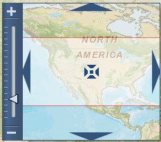
- Using the navigation compass on the right hand side, shown below to zoom in and out and move around the map:
To look up a County Name by FIPS Code, visit: https://www.census.gov/geo/www/ansi/countylookup.html
Interactive Tools of the Viewer
Use the interactive tools displayed in left hand tool bar to navigate the map, generate and view NVUE statistics, and draw and measure the distance and length of two points.
Descriptions for these tools are described below:
 Allows the user to click and drag the map to navigate
 Allows a user to click on an area of the map and retrieve an interactive NVUE Report for a region, a state, county, or watershed
 Allows a user to click and explore the existing and requested studies shown on the map
 Allows a user to click two points on the map and measure the distance between two points
 Allows the user to click and drag the map to navigate
 Allows a user to enter in a comment on an area or request a study
NVUE Reporting
Creating NVUE Reports via the Viewer
New, Validated, and Updated Engineering (NVUE) compliant is a term used to describe flood studies which were completed using up-to-date engineering methodology and conducted in areas which have not seen significant Physiological, Climatological and Engineering methodology (PCE) changes since the date of the area’s effective flood study. The NVUE percentage metric helps identify the portion of FEMA’s inventory of studies that do not have identified needs that would warrant a re-study.
NVUE Reports via the Viewer the can be generated by Region, State, County, or the 8-digit Hydrologic Unit Code (HUC8) code by selecting the respective radio button under ‘NVUE Reports by Type.’ The ‘by County’ and ‘by HUC8’ options will become available once zoomed in to the appropriate level.
When selecting the NVUE interactive tool icon, the map will highlight with the report type (i.e., Region, State, County, or HUC 8) that is selected. Once you have navigated to an area of interest and click on the map, a NVUE Data Report for the selected region, state, county, or HUC8 area will generate.
Users may also use the NVUE Report Generator tool as another method to generate a NVUE Report.
NVUE Report Generator
The NVUE Report Generator tool, accessed by selecting NVUE Reports on the top menu, is another method to generate NVUE reports for the entire nation, specific regions, state, counties, communities, or watersheds. The generated report can be exported to the following file formats:
- Rich Text File (RTF)
- Microsoft Excel (XLS)
- Microsoft Word (DOC)
- Portable Document Format (PDF)
- Crystal Report (RPT)
- Comma Separated Values (CSV)
- Extensible Markup Language (XML)
To generate a NVUE report and statistics within a political boundary, select the Region, State, and/or County combination and select NVUE by Political Boundary.
You may also generate the NVUE statistics for a specific watershed by selecting the desired Region, State, and/or County of interest and then selecting the desired watershed(s) from the ‘List of Watersheds’ and selecting the NVUE by Watershed button. Or, if you have a specific Community ID or HUC 8 code number, you can narrow the results returned by entering values in those fields.
Once the NVUE report has been generated based on the selected criteria, you can export the report by selecting the export icon from the upper left hand corner.
Status Types
Status Type records the actions being taken, or that will be taken, once the Validation Status is determined for a study during update and maintenance cycles of the CNMS Inventory. Status types are useful in understanding and tracking map update investment decisions and better understanding flood risk study progressions.
Validation Statuses
Within the CNMS Database, each study is assigned a Validation Status based on evaluated PCE factors. Stream centerlines hold these study status validation assignments, while polygons are used to hold supporting data used to make the validation decisions.
Four validation statuses exist within the CNMS Database: Valid, Unverified, Unknown, and Assessed.
- Valid status (target condition): A NVUE Compliant study that has been completed using up-to-date engineering methodology and/or conducted in areas which have not seen significant climatological or physiological changes since the effective date of the study.
- Unverified status (requires map update investment): A study that has not passed the Critical and Secondary Element checks part of FEMA’s validation standards and is eligible to receive resources for a re-study in the future or is currently being restudied.
- Unknown status (needs further investigation): A study that is either being currently evaluated, is planned to be evaluated, or lacks enough information to be able to determine a validation status.
- Assessed status: A study in an unmapped area that has been identified for a new study in the current or a future fiscal year or is a deferment of a new study request. Streams not part of FEMA’s SFHA inventory (i.e., Zone X, Zone D, or Area Not Included), that have been, or are being considered for a new study also fall under this validation status category.
Validation Checklist
During the evaluation of a study in CNMS, seventeen elements are used to determine validity based upon FEMA’s current validity standards. Seven elements are considered critical, while the remaining ten are considered secondary. A single deficiency in a critical element is enough to assign an ‘Unverified’ validation status, while it takes four or more secondary deficiencies to do the same. The following elements are evaluated for each detailed study reach.
Critical Elements
- Critical Element 1 - Change in gage record.
- Critical Element 2 - Change in Discharge.
- Critical Element 3 - Model methodology.
- Critical Element 4 - Hydraulic Change.
- Critical Element 5 - Channel Reconfiguration.
- Critical Element 6 - Hydraulic Change 2.
- Critical Element 7 - Channel Area Change.
Major change in gage record since effective analysis that includes major flood events? This field is to capture whether or not a major change in gage records have been observed since the effective analysis was completed.
Updated and effective peak discharges differ significantly based on confidence limits criteria in FEMA's Guidelines and Specifications for Flood Hazard Mapping Partners? This field is to capture whether or not updated and effective peak discharges differ significantly based on FEMA's current confidence limits criteria since the effective analysis was completed.
Model methodology no longer appropriate based on Guidelines and Specifications for Flood Hazard Mapping Partners (i.e. one-dimensional vs. two-dimensional modeling; Coastal Guidelines)?
This field is to capture whether or not the model methodology used to produce the effective analysis still meet current guidelines and specifications.
Addition/removal of a major flood control structure (i.e., certified levee or seawall, reservoir with more than 50 acre-ft storage per square mile)?
This field is to capture whether or not there have been major flood control structures added or removed since the effective analysis was completed.
Current channel reconfiguration outside effective SFHA?
This field is to capture whether or not any channel reconfigurations outside the effective special flood hazard area (SFHA) have been observed since the effective analysis was completed.
5 or more new or removed hydraulic structures (bridge/culvert) that impact BFEs?
This field is to capture whether or not 5 or more new or removed hydraulic structures (bridge/culvert) that impact base flood elevations (BFEs) have been observed since the effective analysis was completed.
Significant channel fill or scour?
This Yes/No field is to capture whether or not significant channel fill or scour has been observed since the effective analysis was completed.
Secondary Elements
- Secondary Element 1 - Regression Equation.
- Secondary Element 2 - Repetitive Loss.
- Secondary Element 3 - Impervious Area.
- Secondary Element 4 - Hydraulic Structure.
- Secondary Element 5 - Channel Improvements.
- Secondary Element 6 - Topography Data.
- Secondary Element 7 - Vegetation or Land Use.
- Secondary Element 8 - Coastal Dune.
- Secondary Element 9 - High Water Mark.
- Secondary Element 10 - Regression Equation.
Use of rural regression equations in urbanized areas?
This field is to capture whether or not a regression equation intended for rural use was used in an urbanized area.
Repetitive losses outside the SFHA?
This field is to capture whether or not repetitive loss claims have been filed for properties outside the SFHA.
Increase in impervious area in the sub-basin of more than 50 percent (i.e., 10 percent to 15 percent, 20 percent to 30 percent, etc.)?
This field is to capture whether or not there is a significant increase in impervious surface in the sub-basin since the effective study.
More than 1 and less than 5 new or removed hydraulic structures (bridge/culvert) impacting BFEs?
This field is to capture whether or not there have been 1 to 4 new and/or removed hydraulic structures that impact BFEs since the effective study. This should not be used to supersede the Letter of Map Revision process.
Channel improvements / Shoreline changes?
This field is to capture whether or not there have been any channel improvement or shoreline changing projects since the effective study.
Availability of better topography/bathymetry?
This field is to capture whether or not there are new topographic data meeting FEMA minimum standards available since the effective study.
Changes to vegetation or land use?
This field is to capture whether or not there are significant changes in land use or vegetation since the effective study.
Failure to identify primary frontal dune in coastal areas?
This field is to capture whether or not there was a failure to identify a primary frontal dune in coastal areas since the effective study.
Significant storms with High Water Marks.
This field is to capture whether or not there is recent storm surge high water mark data now available following the effective study.
New regression equations available?
This field is to capture whether or not there is a new regression equation available since the effective study.
Reset your CNMS Account Password
To reset your CNMS account password, visit the CNMS Account Login page and select ‘Recover Password’ or directly navigate to the Recover Password page. Enter in username (user’s email address) and a temporary password will be sent to your email address. Upon signing back into the CNMS application with the temporary password, you will need to enter in new password information.
Additional Resources and Information
To learn more about the CNMS application, visit the CNMS webpage to review additional user resources, including a training tutorial and factsheet.
Other applications and resources that may be of interest users include:
- FEMA National Flood Insurance Program Home Page- General NFIP Information and Terminology
- FEMA Map Service Center (MSC)- FEMA’s online portal for viewing and ordering flood map products
- Project Planning and Purchasing Tool (P4)- Provides a platform for FEMA Regions to plan projects on multi-year basis, sequence projects to be funded annually, and develop the ordering template and Statement of Priorities (SOP) for purchases. The P4 tool enables FEMA to accurately capture scope and quantity details and estimate approximate costs and associated program measure contributions for Risk Mapping, Assessment, and Planning (MAP) investments throughout the program planning processes.