- Current Hazards
- Forecasts
- Current Weather
- Radar Imagery
- Climate
- Weather Safety
- Additional Info
- Office Info
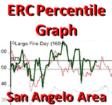
Fire Weather
|
|
Latest Text Product Selector (Selected product opens in a new window)
|
|
|
|
|
|
F o r e c a s t s |


|
|
|
|
|
O b s e r - | v a t i o n s |


|
|
|
|
|
S i t u a t i o n | O u t l o o k s |


|
|
|
|
G r e e n n e s s & | D r o u g h t & | A d d l I n f o |


| Enter the air temperature and the dew point in degrees Fahrenheit, then click on the Calculate RH to compute the relative humidity. |
- National Weather Service
- San Angelo, TX Weather Forecast Office
- 7654 Knickerbocker Road
- San Angelo, TX 76904
- 325-944-9445
- Page Author: SJT Webmaster
- Web Master's E-mail: sr-sjt.webmaster@noaa.gov
- Page last modified: August 30th 2011 8:18 PM