Local
forecast by
"City, St" |
|
Search
by city or zip code. Press enter or select the go button to
submit request
|
|
| Snow Water Equivalent Maps |
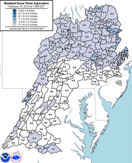 |
Snow water equivalent is the depth of water that would cover the ground if the snowcover was in a liquid state. Our river forecasting models use this value , along with temperature and sunshine information, to estimate the amount of snowmelt entering the river channels. The actual number is very rarely field checked, but rather estimated from the total snow depth, observed liquid equivalent precipitation, i.e. how much precipitation fell if it was entirely in the form of rain, and the amount of snowmelt.
|
 |
Snow depth is not always a true indicator of the average snow depth over an entire area, but the values are used qualitatively to see if the estimated water equivalents are in need of review or revision.
|
Additional Snow/Ice Links |
|
|
Popular Links:
River Forecasts, Current Stages, Precipitation Departure Maps, Weather, Radar, F.A.Q. |
|
NOAA's National Weather Service
Middle Atlantic River Forecast Center
328 Innovation Boulevard, Suite 330
State College, PA 16803
Page Authors: Jason Nolan
Webmaster's E-mail: marfc.webmaster@noaa.gov
Page last modified:
January 16, 2012 10:18 AM
|
Disclaimer |
Privacy Policy |
| Credits |
About Us |
| Glossary |
Career Opportunities |
|


