|
| |
Thomas Jefferson Quicks Hole Survey
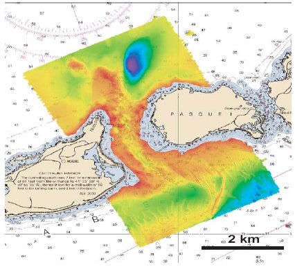 |
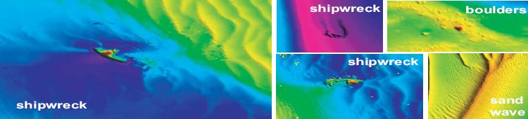
Quicks Hole is a narrow passage between Pasque and Nashawena Islands in the Elizabeth Islands chain that divides Buzzards Bay from Martha’s Vineyard Sound. It is the only safe passage between the islands for vessels with drafts >10 ft. The ~1 km-wide passage contains several navigationally significant hazards including swift currents at all tidal stages and foul ground to either side of the main channel. With these factors in mind, the U.S. Coast Guard requested a modern hydrographic survey of Quicks Hole.
The crew of NOAA Ship Thomas Jefferson conducted a modern hydrographic survey of Quicks Hole from August 10 to September 1, 2004. The highly skilled ship personnel acquired high resolution bathymetric data and side scan sonar imagery of the entire navigable area. Digital terrain models created from the data revealed giant sand waves rising up to 20 ft off the bottom, huge glacial erratic boulders, and several uncharted wrecks. Aside from updating the charts in the region, the high resolution DTM’s created from this survey will be used by scientists at the USGS office in Woods Hole, MA and by the Massachusetts Coastal Zone Management to improve their understanding of the marine environment in Vineyard Sound and Buzzards Bay. |
 |
|
Digital Terrain Models (DTMs) that show features on the ocean bottom in Quicks Hole, Ma. | |
|