 |
|
|
|
 |
DECADES after armed conflicts end, land mines continue
to maim and kill thousands of innocent civilians. Today,
79 countries are plagued by mines buried under thousands of square kilometers of land, and most of these countries possess limited resources to remove them. The use of metal detectors and the manual prodding of soil remain the most trusted demining techniques, but they are hindered by false positives and are time-consuming, costly, and dangerous. In fact, for every 1,000 to 2,000 mines cleared using conventional techniques, one deminer is killed or maimed.
A safer method that would reduce the number of false positives and the time and cost of demining operations has long been needed. To meet this need, a team of Lawrence Livermore engineers led by Christine Paulson and Kique Romero, together with colleagues at First Alliance Technologies, LLC, in San Ramon, California, and Hystar Aerospace Corporation in Vancouver, Canada, has developed the land mine locator. The developers received an R&D 100 Award for this innovative technology. Initial work was funded by Livermore’s Laboratory Directed Research and Development Program.
The land mine locator is an aerial detection system. The system is equipped with Livermore’s LANDMARC (land mine detection advanced radar concept), which features an ultrawideband radar-sensing technology called iRadar and tomographic algorithms that provide three-dimensional subsurface images. LANDMARC is deployed on the remotely operated Hystar aerial platform, thereby reducing the time and cost of demining while significantly improving the safety of personnel and equipment.
 |
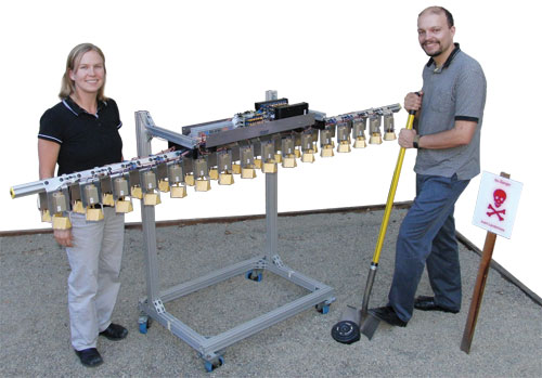
| Development team for the land mine locator at Livermore: (front row, from left) Sean Lehman, Benjamin Fasenfest, Noel Peterson, Christine Paulson, Kique Romero, Pat Welsh, Bob Yamamoto, and Dave Chambers; (back row) Jim Zumstein, Brian Guidry, Mark Vigars, Philip Top, John Parker, Garth Pratt, Steven Bond, Greg Dallum, Peter Haugen, John Chang, John Breneman, and Matthew Breneman. (Not shown: Steve Azevedo, Christopher Gardner, and Jae Jeon.) |
Land Mines Are Long-Lived
Land mines are explosive devices placed in the ground and triggered by mechanical or electronic proximity sensors. After conflicts cease, unexploded land mines can remain intact for decades, killing and maiming civilians, impeding reconstruction efforts, and rendering agricultural lands useless. The Landmine Monitor Report 2008 assesses that many thousands of square kilometers of land are contaminated by up to 100 million mines and other explosives. In 2007, about 1,400 people were killed
and 4,000 injured by mines or other explosive remnants of war.
An estimated 100,000 mines are removed each year. At that rate, clearing 40 to 50 million mines would require 450 to 500 years, assuming no new mines are laid. However, the pace of mine removal is far slower than the rate at which new mines are being placed.
According to Paulson, current demining methods are decades old and are extremely tedious because metal detectors cannot discriminate metallic mines from innocuous metallic clutter. Some antipersonnel mines are mostly plastic except for small metal parts. Detecting these metal parts requires the metal detector’s sensitivity to be turned up. As a result, most “mines” turn out to be harmless objects such as bottle caps, bullet casings, nails, or tin cans. Demining teams typically uncover 100 to 1,000 innocuous metal objects for each mine found.
 |
| Lead engineers Christine Paulson and Kique Romero demonstrate the iRadar array at Livermore’s inert mine test pit. |
Two Technologies Combine
For more than a decade, Livermore researchers have been working on applying their patented ultrawideband technology to the worldwide problem of demining. The iRadar sensor is compact, low power, inexpensive, and unusually versatile. The sensor can send out extremely short electromagnetic pulses over an exceptionally wide range of frequencies, permitting much finer resolution of materials than other sensing systems.
Livermore’s LANDMARC technology consists of an array of lightweight, ground-penetrating iRadar sensors and a signal-processing “engine” that detects and maps land mines in three dimensions. (See the figure above.) In this way, pipes can be distinguished from rebar, rebar from land mines, and land mines from clutter in general.
The land mine locator combines LANDMARC with the revolutionary Hystar helium-filled aerial platform, which can cruise at 72 kilometers per hour. The platform can also rotate 360 degrees while hovering or in directional flight. The 12-meter-diameter unit uses a reversible fan propeller at its center to ascend and descend, and jet engine propellers on its rim to move forward, backward, or sideways and to spin in place.
Hystar’s telescoping mast lowers a sensor bar on which individual iRadar units are secured. The sensor bar typically hovers between 1 and 2 meters above the ground. An onboard central control unit handles power, sensor coordination, and data acquisition.
Operators on the ground in a mobile base-station vehicle wirelessly control the land mine locator. The raw data collected from the iRadar array are entered into a Livermore software application developed specifically to help detect and precisely locate land mines during demining operations.
Technology Soars over Alternatives
Paulson notes that several alternative technologies have been studied for mine detection, including ground-penetrating radar and mechanical demining vehicles that till the soil. “However, each has had significant drawbacks,” she says. Unlike other methods, the land mine locator uses a remotely operated aerial platform, allowing mine detection to be performed without placing personnel or equipment in danger. Other potential applications for the land mine locator, according to Romero, are the detection of roadside bombs and improvised explosive devices, and the nondestructive evaluation of roadways, bridges, and buildings.
With the land mine locator in use, the world will at last have
a safer method to detect mines. As a result, nations will be able
to confidently reclaim millions of square kilometers from this
long-lasting scourge of war.
—Arnie Heller
Key Words: demining, Hystar, iRadar, LANDMARC, land mine locator, R&D 100 Award, ultrawideband radar.
For further information contact Christine Paulson (925) 423-7362 (paulson4@llnl.gov) or Kique Romero (925) 423-2830 (romero29@llnl.gov).
S&TR Home | LLNL
Home | LLNL Site Map | Top
Site designed and maintained by TID’s Web & Multimedia Group
Lawrence Livermore National Laboratory
Operated by Lawrence Livermore National Security, LLC, for the
U.S. Department of Energy’s National Nuclear Security Administration
Privacy & Legal Notice | UCRL-TR-52000-09-10/11 | October 2, 2009