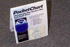
HOME | ABOUT US | CONTACT | REGIONAL MANAGERS
 
  Nautical Charts & Pubs  
 
  Nautical Charts & Products  
     •   Traditional Paper Charts  
     •   Print-on-Demand Charts (POD)  
     •   Raster Navigational Charts: NOAA RNC®  
     •   Electronic Navigational Charts: NOAA ENC®  
     •   PocketCharts  
     •   BookletChart™  
     •   Chart Updates (LNM and NM Corrections)  
 
  Nautical Charting Publications  
     •   United States Coast Pilot®  
     •   U.S. Chart No. 1  
     •   Chart Catalogs  
     •   Dates of Latest Editions (DOLE)  
     •   Upcoming New Editions (SON)  
 
  Nautical Charting Utilities  
     •   NOAA's On-Line Chart Viewer  
 
  Historical Products  
     •   Historical Maps and Charts  
     •   Historical Coast Pilots  
 
  Learn About Charting Products  
     •   Obtain Charting Products  
     •   How Publications are Updated  
     •   Differences Between Maps & Charts  
     •   Learn About Nautical Charts  
     •   DGPS & Your Chart  
     •   Differences Between NM and LNM  
     •   Differences Between RNCs and ENCs  
     •   Differences Between NOAA ENC® and DNC®  
     •   Differences Between ENC and ENC®Direct to GIS  
 
  Data Portals  
     •   Tides and Currents (General)  
     •   nowCOAST: Real-Time Coastal Data Map Portal  
     •   Physical Oceanographic Real-Time System (PORTS)  
     •   Nautical Charting Links  
 
  Resources  
     •   Coast Survey Partners  
     •   Chart Carriage Requirements  
     •   Report a Charting Discrepancy  
     •   Chart Inquiries (questions/comments)  
     •   Cartographic Automation  
 

PocketCharts
Picture of a PocketChart laid out on a table. Front and back side of charts are shown. In addition, folded up PocketCharts are shown. The new NOAA PocketChart™ is a special-purpose map for beginning recreational boaters. Beginning boaters can use the PocketChart to help answer their two most frequent questions: "Where am I?" and "How do I get to…?" This inexpensive, introductory charting product has a miniature NOAA nautical chart on one side, and safety, boating, and educational information on the reverse side. PocketCharts may be purchased for about $6 each from numerous retail outlets serving boaters. NOAA reassembles that PocketChart with the most up-to-date information every time a chart changes.
Obtain
   •   PocketChart Agents
Chart Side
The chart side is a complete, full-color NOAA chart that has been reduced in scale. (On average, the charts are 34% of full scale.) The primary text is legible, but text that appears small on the full-scale charts is even smaller on these reduced-scale charts. The result is suitable for its intended use as a locator, but is not suitable for real navigation.

Additionally, an overlay has been added to the chart to help boaters use the PocketChart as a locator. For certain populated places that are important to recreational boaters, the chart has been overlaid with enlarged text. Key aids to navigation, visible landmarks, and water bodies have also been highlighted to help with visual navigation.

 Picture of the front cover of a  NOAA PocketChart that is folded up.
Reverse Side
When the PocketChart is folded, part of the reverse side becomes a cover with the chart title and a small sketch of the area the chart covers. The rest of the reverse side is a mix of safety, educational, and boating information that is compiled from federal, state, and cooperating private sources. Some of the information is specific to the chart, and some information applies to all areas. The reverse-side information differs from chart to chart.

Reverse-side information may include:

  • Selected information from the United States Coast Pilot®
  • Table 2 tide correctors
  • Safety information from U.S. Coast Guard publications
  • State rules and regulations (e.g., boating education regulations) and boat licensing requirements
  • Nautical chart design and usage information
  • U.S. Coast Guard navigation rules
  • National Estuarine Research Reserve information
  • Weather information and warnings

This information will increase the safety and enjoyment of a beginner's boating experience.


User Survey  | Privacy Policy  |  Disclaimer  |  NOAA's National Ocean Service  |  NOAA  |  U.S. Department of Commerce 
Web site owner: United States Office of Coast Survey