
U.S. IOOS Coastal and Ocean Modeling Testbed

Snapshot of Coastal and Ocean Modeling Testbed website homepage.
Coastal waters and lowlands of the U.S. are threatened by climate change, sea-level rise, flooding, oxygen depleted “dead zones”, oil spills and unforeseen disasters.
With funding from NOAA’s Integrated Ocean Observing System Office, Southeastern University Research Association, SURA facilitated strategic collaborations among experts from academia, federal operational centers and industry and guided the U.S. IOOS Coastal and Ocean Modeling Testbed (COMT) through its first highly productive phase.
The mission of the COMT is to accelerate the transition of advances from the coastal ocean modeling research community to improved operational ocean products and services. The long-range vision of the program is to increase the accuracy, reliability, and scope of operational coastal and ocean forecasting products.
Current successes of the Coastal and Ocean Modeling Testbed include:
- Improving inundation forecasting to enable coastal communities to have more accurate and timely forecasts of storm events and flooding patterns to protect life and property.
- Improving understanding and forecasting hypoxia to ensure the safety of beach users.
- Improving wave and surface current modeling for more accurate and timely information about waves and rip currents for beach users.
Applications
Coastal Inundation
The objective of the coastal inundation group is to provide meaningful guidance on the behavior (e.g., accuracy, robustness, execution speed) and implementation requirements (e.g., resolution, parameterization, computer capacity) of models that are presently in “operational use”, or that are under consideration for such use, for computing waves, storm surge and inundation. Additionally, they are helping to develop testbed infrastructure that promotes standards, interoperability and data/model archives to greatly facilitate future model evaluation.
http://testbed.sura.org/node/522
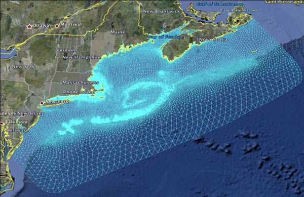
Gulf of Maine / Scituate Harbor - Extratropical Domain
(top)
Shelf Hypoxia
The objective of the Shelf Hypoxia team is to create a near real-time synoptic scale hypoxia forecast capability to capture the true temporal variability of formation, extent, duration and severity of the Gulf of Mexico Dead Zone. The long term goal is to develop and transition to operations a coupled biogeochemical/physical model to forecast the real-time, synoptic scale development and evolution of physical and ecosystem processes in the Northern Gulf of Mexico.
http://testbed.sura.org/node/551

Five Hydrodynamic Models Configured for the Chesapeake Bay
Estuarine Hypoxia
The objective of the Estuarine Hypoxia team is to evaluate and transition scientific findings for use in short term (≤~15 day) hypoxia forecast tools at NOAA. Additionally, the team is further exploring model properties that lead to the inability of hydrodynamic models to capture the observed intensity of density stratification in moderately energetic estuaries such as the Chesapeake Bay.
http://testbed.sura.org/node/524
(top)
Cyberinfrastructure

Snaphot from the cyberinfrustructure Data Expolrer
The objective of the Cyberinfrastructure team is to work with each of the other teams to facilitate maintaining a database to collect observational data with valuable metadata for everyone to be able to access. Additionally, the team assists in the development of tools to compare forecast models in order to assess models and modeling tools to help determine which can be used in an operational setting at a federal level.
http://testbed.sura.org/node/525
(top)
Collaboration
First and foremost, the Testbed has enabled significant community building (within the modeling community as well as enhancing academic and federal operational relations) which has dramatically improved model development.
The IOOS Program Office
- Manages the COMT grant
- Liaises with other federal partners including; NCEP, CO-OPS, CSDL, USACE, USN, USCG, USGS. Liaising to spread the understanding of the purpose of the Testbed, to gain interest from other agencies to participate, to gain financial support, to facilitate connections between research and operational community to enable transitioning of products from the COMT, etc…
- Drafts and staffs documentation to create a permanent framework for the COMT
- Provides support in budget planning to enable future funding support to maintain the Testbed
- Assists in development of communications strategy for COMT. Advocates for the COMT, spreading the word, touting successes at meetings, conferences, etc…
- Participates in progress calls with COMT teams, leads monthly calls with team leads and technical advisory group (TAG), liaise with TAG to ensure COMT is progressing effectively, coordinates with non-federal partner (SURA) to ensure proposal goals are being met, etc.
Collaboration Within the Project Teams
The Cyberinfrastructure team has assembled a robust infrastructure to facilitate model assessment based on community standards, including a distributed data repository, automated cataloging mechanism, quick browse facility, and tools for flexible and detailed scientific investigation of both model output and data. Models, tools and techniques from the Testbed are already starting to be incorporated into the NOAA operational framework, reducing the transition time from research to operations.
The Inundation team has developed a common infrastructure for 2 hurricanes in the Gulf of Mexico and 2 extra tropical storms in the Gulf of Maine. Dr. Don Slinn, University of FL, is working with the National Hurricane Center to transition a coupled SLOSH/SWAN model to allow incorporation of waves into the operational forecasts.
The Shelf Hypoxia team is working with NOAA’s Coast Survey Development Laboratory (CSDL) to transition biogeochemical operating equations for implementation into FVCOM. They also created a multi-year hypoxia data set available in Testbed cyberinfrastructure as well as with the National Data Buoy Center (NDBC).
The Estuarine Hypoxia team has compared 5 different hydrodynamic models with 5 dissolved oxygen (DO) models and a simple dissolved oxygen formulation for forecasting the location and timing of seasonal hypoxia was transitioned to NOAA's Coast Survey Development Lab’s research version of the Chesapeake Bay Operational Forecast System (CBOFS) for evaluation.
(top)
Background
The Coastal Ocean Modeling Testbed (COMT) was initiated by IOOS as a pilot project, in June 2010, to investigate the utility of a permanent Testbed by selecting two important coastal processes, hypoxia and inundation, and investigating model skill in several regions rich with historical data. IOOS led the effort by designating a full-time program manager to coordinate the development and execution of the COMT.
Based on the early success of the COMT, a second grant was approved and initiated in August, 2011 to define what a sustained COMT should look like and to develop a permanent framework and future plan for the COMT. SURA has been the grant recipient for both grants responsible for coordinating, liaising and managing several sub-contracts to fully implement the COMT.
The Testbed will serve as a conduit between the federal operational and research communities and allow sharing of numerical models, observations and software tools. These tools are needed to elucidate, prioritize, and resolve federal operational coastal ocean issues associated with a range of existing and emerging coastal oceanic, hydrologic, and ecological models.
(top)
Mission
To use applied research and development to accelerate the transition of scientific and technical advances from the coastal ocean modeling research community to improved operational ocean products and services (i.e. via research to operations and also operations to research).
Vision
A National Coastal Ocean Modeling Testbed to enhance the accuracy, reliability, and scope of the federal suite of operational ocean modeling products to meet the needs of a critical and diverse user community.
Definition
The US IOOS COMT will serve as a conduit between the federal operational and research communities and allow sharing of numerical models, observations and software tools. These tools are needed to elucidate, prioritize, and resolve federal operational coastal ocean issues associated with a range of existing and emerging coastal oceanic, hydrologic, and ecological models. The COMT is intended to be executed in the non-profit sector, anchored through infrastructure and transitional processes in an operational center. It will serve multiple federal agency operational requirements, providing funding opportunities that will target improved simulation and forecasts of coastal and ocean processes with societal importance.
(top)
Operations
Organization
The COMT will comprise an Executive Oversight Board (EOB), a Technical Advisory Group (TAG) and a Transition Management Group (TMG). The EOB will provide overarching guidance on operational needs, federal priorities and approve funding priorities. The TAG will comprise both federal operational and research scientific advisors to offer direction and endorsement of ongoing and planned activities. The TMG will execute plans approved by the EOB and TAG and provide direction on priorities, supervision and accountability to ensure success. Additionally, the COMT will foster partnerships at all levels to allow multi-sector collaboration, uniting a broad community of federal, non-federal and academic partners.
Processes
Terms of Reference and an Implementation Plan are in draft, which will define how the Testbed will be managed. They will be posted upon approval.
Cyberinfrastructure (CI)
CI is a critical piece of the COMT, providing efficient and powerful tools and techniques to enable model-model and model-data comparison as well as promulgating and supporting community standard data formats, which enable transition to federal operational centers. The CI allows models and data to be accessed from a distributed repository via web services, and provides tools for quantitative analysis and visualization. The minimum capabilities will include:
- Maintaining a server environment, tools and toolkits to facilitate access to data, models, model input files, and model results
- Developing standards-based software and skill assessment metrics to enable data and model comparisons for the Testbed and for the geosciences community.
- Documenting procedures and best practices for managing the model output life cycle.
- Ensuring High Performance Computer access and allocation to support computational-intensive simulations required to meet Testbed priorities
(top)
Resources and References
Southeastern University Research Association http://www.sura.org/home/index.html
Testbed Results Reports
Final Report Part 1: A Super-Regional Testbed to Improve Models of Environmental Processes on the U.S. Atlantic and Gulf of Mexico Coasts (pdf)
Final Report Part 2: Comments by the Technical Advisory & Evaluation Group (pdf)
For Questions and Enquiries:
Becky Baltes, tel: 301.427.2427