
Search and Rescue Satellites
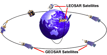
 Low-Earth Orbiting Search And Rescue (LEOSAR) Satellites
- NOAA Polar Orbiting Environmental Satellites (POES) – known as ‘SARSAT’
- ESA/EUMETSAT Polar Orbiting Meteorological Satellites (MetOp) – known as “SARSAT”
Geostationary Orbiting Search And Rescue (GEOSAR) Satellites
- NOAA Geostationary Orbiting Environmental Satellites (GOES)
- ISRO Indian National Satellite (INSAT)
- ESA Metosat Second Generation (MSG)
Low-Earth Orbiting Search And Rescue (LEOSAR) Satellites
The keystone to the Cospas-Sarsat System are the low-earth orbiting (LEO) satellites from which the system takes its name. These satellites provide the ability to detect and locate 406 MHz alerts worldwide.
 SARSAT is an instrument package flown aboard the NOAA series of environmental satellites operated by NOAA's National Environmental Satellite, Data and Information Service (NESDIS). These satellites orbit at an altitude of 528 miles and complete an orbit every 100 minutes. Their orbits are inclined 99 degrees from the equator. Typically, each satellite monitors the earth for various weather and climate data. Yet, each satellite also carries a Search and Rescue Repeater (SARR) which receives and retransmits 406 MHz signals anytime the satellite is in view of a ground station. Also carried is a Search and Rescue Processor (SARP) which receives 406 MHz transmissions, provides measurements of the frequency and time, then retransmits this data in real-time. The satellite also stores each 406 MHz signal it receives and continuously downloads this data for up to 48 hours ensuring ground stations around the world receive it. That is, if the satellite was not in view of a ground station when it received a beacon signal, the next ground station that sees that satellite will receive the data. This provides global coverage for 406 MHz distress signals. The SARR is provided by the Canadian Department of National Defence and the SARP is provided by the French Center National D'Etudes Spatiales (CNES).
Geostationary Orbiting Search And Rescue (GEOSAR) Satellites
 As you can see from this image taken today from GOES-East, geostationary satellites are capable of continually viewing large areas of the Earth. These geostationary (GEO) satellites are also able to provide immediate alerting and identification of 406 MHz beacons. The GEO satellites are not able to use Doppler location processing since they have no relative motion between them and the emergency beacons. Therefore, they are not able to determine a location for a beacon. They can, however, provide immediate alerts. This is a valuable tool for SAR personnel since it allows them to begin their initial verification of the alert using the National 406 MHz Beacon Registration Database. Often this detective work yields a general location of the vessel or aircraft in distress and SAR assets can be readied or dispatched to that general area. Ideally, a SARSAT satellite will fly over the beacon within the next hour and calculate a Doppler location which will be given to the SAR personnel who may already be en route.
There is a significant advantage with a GEOSAR satellite detection of a beacon with encoded location. Here’s how it works: specially made emergency beacons determine their location using a GPS receiver that is either integrated into the beacon (called a location protocol beacon) or fed by an external GPS receiver. This accurate location information (generally around a football field in size for positional accuracy) is then encoded into the 406 MHz signal that is transmitted by the beacon. The USMCC then receives that signal with the location and notifies the RCC accordingly. This information can often be derived in a matter of minutes! Since every second counts in reaching the scene of a distress this means that there is an increased chance of survival.
Without a doubt, the early warning capability of the GEOSAR constellation provides a valuable tool to increase the effectiveness of the Cospas-Sarsat system and, ultimately, save more lives.
 Two important considerations
First, a GPS-equipped beacon only works when the receiver has a clear view of the sky in order to permit the receiver to self-locate. Often times, conditions do not permit this which may either distort the positional accuracy or negate it altogether. Because of this, the Cospas-Sarsat System relies upon the Doppler locating effect as the primary means for locating a beacon. This process is able to overcome the limitations of a GPS unit and still generate a fairly accurate location…within a mile for positional accuracy. Secondly, the GEOSAR component only works if the beacon is registered with NOAA. Without registration, the RCCs are unable to react as quickly…and ultimately this may delay a SAR response should you be in an emergency. If you have a 406 MHz beacon and have not registered it, please do so by clicking here to access the National 406 MHz Registration Database.
Status of LEOSAR and GEOSAR Payload Instruments
The status of the Cospas-Sarsat space segment can be found on the Cospas-Sarsat website.