Degree Heating Weeks

clickable global map of degree heating weeks
DHWs in Mediterranean and Red Sea DHWs around India DHWs east of Japan DHWs around Hawaii DHWs around Central America DHWs West of Africa DHWs in Mediterranean and Red Sea DHWs around southern Africa DHWs in the southern Indian Ocean DHWs around Australia DHWs in the South Pacific DHWs west of South America DHWs east of Brazil DHWs around southern Africa Click on the image to zoom in.

Current images: Global | E.Hem. | W.Hem. | Pacific | Caribbean | Coral Triangle


Data Formats Available

images Image Archives
Regional imagery and image archives from OSDPD.
Google Earth Google Earth
All of our satellite data products are available on Google Earth.
Virtual Stations Virtual Stations
Imagery, graphs, ASCII data, and e-mail alerts for reef pixels around the world.
animations Animations
Data animations and downloadable animated GIF files from OSDPD.
HDF data HDF data files
Raw data in Hierarchical Data Format (HDF), with free NOAA viewing software.


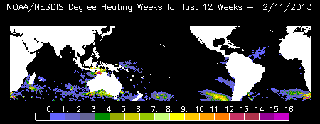
The DHW product shows accumulated thermal stress, which can lead to coral bleaching. The scale goes from 0 to 16 degree-weeks. Spatial resolution is one-half degree.


Product description in the tutorial.
Technical details on the methodology page.