The State House in
Philadelphia
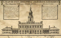
A Map of Philadelphia and Parts Adjacent,
With A Perspective View
of the State House.
Philadelphia: Lawrence Hebert, 1752
Geography & Map Division
Gift of the Madison Council,
the Phillips Society and
J. Thomas Touchton and
Mrs. and Mrs. Isadore Scott, 1998 (6B.1)
|
Drawn by George Heap, a surveyor and city coroner of Philadelphia,
and Nicolas Scull, Surveyor General of the Province of Pennsylvania,
this map shows streams, roads, and names of the landowners in
the vicinity of Philadelphia. The top third of the map contains
the first illustration in any format of the State-House or Independence
Hall, home of the Federal Convention of 1787. The map was issued
before the State-House was completed. Scull and Heap apparently
worked from the architectural plans to depict the unfinished belfry.
|

