Map
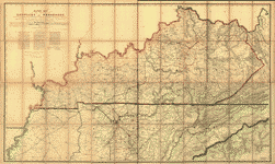
Military map of the States of Kentucky and Tennessee, within eleven miles of the 35th parallel of latitude or southern boundary of Tennessee; compiled from the best authentic original maps, various documents, and miscellaneous latest sources of information;
| Format |
Map |
|---|---|
| Contributors |
Swann, Charles E. |
| Dates |
1863 |
| Location |
Kentucky Tennessee United States |
| Language |
English |
| Subjects |
Civil War History Kentucky Tennessee United States |
- Title
- Military map of the States of Kentucky and Tennessee, within eleven miles of the 35th parallel of latitude or southern boundary of Tennessee; compiled from the best authentic original maps, various documents, and miscellaneous latest sources of information;
- Description
-
Scale 1:350,000.
-
LC Civil War Maps (2nd ed.), 216.8
-
Another issue.
-
In this issue Camp Burnside on the Cumberland River is named, the lithographer's name has been revised, and a dotted line representing the "out line of coal field" has been added in the southeastern quadrant.
-
Description derived from published bibliography.
-
Available also through the Library of Congress web site as raster image.
-
1 map, 128 x 215 cm., mounted to fold to 33 x 19 cm.
- Creator
- Swann, Charles E.,
- Created Published
-
Cincinnati, O., Ehrgott, Forbriger & Co., Lithographers, Engravers & Printers, 1863.
- Subject Headings
-
-
Kentucky--History--Civil War, 1861-1865
-
-
Tennessee--History--Civil War, 1861-1865
-
-
United States--Kentucky.
-
-
United States--Tennessee.
- Notes
-
-
Scale 1:350,000.
-
-
LC Civil War Maps (2nd ed.), 216.8
-
-
Another issue.
-
-
In this issue Camp Burnside on the Cumberland River is named, the lithographer's name has been revised, and a dotted line representing the "out line of coal field" has been added in the southeastern quadrant.
-
-
Description derived from published bibliography.
-
-
Available also through the Library of Congress web site as raster image.
- Medium
-
1 map, 128 x 215 cm., mounted to fold to 33 x 19 cm.
- Call Number
-
G3951.S5 1863 .S9
- Repository
-
Library of Congress Geography and Map Division Washington, D.C. 20540-4650 dcu
- Digital Id
-
g3951s cw0216800 http://hdl.loc.gov/loc.gmd/g3951s.cw0216800
- Library of Congress Catalog Number
- 99447356
Rights & Access
The maps in the Map Collections materials were either published prior to 1922, produced by the United States government, or both (see catalogue records that accompany each map for information regarding date of publication and source). The Library of Congress is providing access to these materials for educational and research purposes and is not aware of any U.S. copyright protection (see Title 17 of the United States Code) or any other restrictions in the Map Collection materials.
Note that the written permission of the copyright owners and/or other rights holders (such as publicity and/or privacy rights) is required for distribution, reproduction, or other use of protected items beyond that allowed by fair use or other statutory exemptions. Responsibility for making an independent legal assessment of an item and securing any necessary permissions ultimately rests with persons desiring to use the item.
More about Copyright and other Restrictions
For guidance about compiling full citations consult Citing Primary Sources.
Part of...
-
Civil War Maps
[2281]
-
Military Battles And Campaigns Cartographic Items
[3867]
-
Geography And Maps Division
[60803]
-
American Memory
[1121009]
More maps like this
-
 Military map of the States of Kentucky and Tennessee, within eleven miles of the 35th parallel of latitude or southern boundary of Tennessee; compiled from ...
Contributor:
Swann, Charles E.
Site:
American Memory-cultural, Main Catalog
Original Format:
Map
Date:
1865
View catalog record
Military map of the States of Kentucky and Tennessee, within eleven miles of the 35th parallel of latitude or southern boundary of Tennessee; compiled from ...
Contributor:
Swann, Charles E.
Site:
American Memory-cultural, Main Catalog
Original Format:
Map
Date:
1865
View catalog record
-
 Map of Kentucky and Tennessee.
Site:
American Memory-cultural, Main Catalog
Original Format:
Map
Date:
1864
View catalog record
Map of Kentucky and Tennessee.
Site:
American Memory-cultural, Main Catalog
Original Format:
Map
Date:
1864
View catalog record
-
 Map of the surveys made for the U.S.M.R.R., 1863 & 4, from Kentucky to east. Tenn. /
Contributor:
Clark, W. P.
Site:
American Memory-cultural, Main Catalog
Original Format:
Map
Date:
1864
View catalog record
Map of the surveys made for the U.S.M.R.R., 1863 & 4, from Kentucky to east. Tenn. /
Contributor:
Clark, W. P.
Site:
American Memory-cultural, Main Catalog
Original Format:
Map
Date:
1864
View catalog record
-
 [Civil War sketch book : Tennessee and Kentucky /
Contributor:
Brooks, Alfred F.
Site:
American Memory-cultural, Main Catalog
Original Format:
Map
Date:
1862
View catalog record
[Civil War sketch book : Tennessee and Kentucky /
Contributor:
Brooks, Alfred F.
Site:
American Memory-cultural, Main Catalog
Original Format:
Map
Date:
1862
View catalog record
-
 Sketch of the vicinity of the Falls of Caney Fork of Cumberland River, Ten. /
Contributor:
Rosson, W.
Site:
American Memory-cultural
Original Format:
Map
Date:
1863
Sketch of the vicinity of the Falls of Caney Fork of Cumberland River, Ten. /
Contributor:
Rosson, W.
Site:
American Memory-cultural
Original Format:
Map
Date:
1863
-
 Sketch of the vicinity of the falls of Caney Fork of Cumberland River, Ten. [sic] /
Contributor:
Weyss, J. E.
Site:
American Memory-cultural, Main Catalog
Original Format:
Map
Date:
1863
View catalog record
Sketch of the vicinity of the falls of Caney Fork of Cumberland River, Ten. [sic] /
Contributor:
Weyss, J. E.
Site:
American Memory-cultural, Main Catalog
Original Format:
Map
Date:
1863
View catalog record
-
 Topographical sketch of the country adjacent to the turnpike between Nolensville and Chapel Hill, Tenn. /
Contributor:
Weyss, J. E.
Site:
American Memory-cultural, Main Catalog
Original Format:
Map
Date:
1863
View catalog record
Topographical sketch of the country adjacent to the turnpike between Nolensville and Chapel Hill, Tenn. /
Contributor:
Weyss, J. E.
Site:
American Memory-cultural, Main Catalog
Original Format:
Map
Date:
1863
View catalog record
-
 Battle of Missionary Ridge or Chickamauga, Tenn.
Contributor:
Sneden, Robert Knox
Site:
American Memory-cultural
Original Format:
Map
Date:
1861
Battle of Missionary Ridge or Chickamauga, Tenn.
Contributor:
Sneden, Robert Knox
Site:
American Memory-cultural
Original Format:
Map
Date:
1861
-
 Lloyd's official map of the State of Kentucky : compiled from actual surveys and official documents, showing every rail road & rail road station with ...
Contributor:
Lloyd, James T.
Site:
American Memory-cultural, Main Catalog
Original Format:
Map
Date:
1862
View catalog record
Lloyd's official map of the State of Kentucky : compiled from actual surveys and official documents, showing every rail road & rail road station with ...
Contributor:
Lloyd, James T.
Site:
American Memory-cultural, Main Catalog
Original Format:
Map
Date:
1862
View catalog record
-
 Across Kentucky
Contributor:
Blakeslee, G. H.
Site:
American Memory-cultural, Main Catalog
Original Format:
Map
Date:
1862
View catalog record
Across Kentucky
Contributor:
Blakeslee, G. H.
Site:
American Memory-cultural, Main Catalog
Original Format:
Map
Date:
1862
View catalog record
-
 Map of the state of Kentucky : with the adjoining territories /
Contributor:
Russell, John
Site:
American Memory-cultural, Main Catalog
Original Format:
Map
Date:
1794
View catalog record
Map of the state of Kentucky : with the adjoining territories /
Contributor:
Russell, John
Site:
American Memory-cultural, Main Catalog
Original Format:
Map
Date:
1794
View catalog record
-
 Kentucky and Tennessee /
Contributor:
Lederle, O.
Site:
American Memory-cultural, Main Catalog
Original Format:
Map
Date:
1862
View catalog record
Kentucky and Tennessee /
Contributor:
Lederle, O.
Site:
American Memory-cultural, Main Catalog
Original Format:
Map
Date:
1862
View catalog record
-
 Map of Kentucky & Tennessee exhitibing the post offices, post roads, canals, rail roads, &c.; by David. H. Burr (Late topographer to the Post Office,) ...
Contributor:
Burr, David H.
Site:
American Memory-cultural, Main Catalog
Original Format:
Map
Date:
1839
View catalog record
Map of Kentucky & Tennessee exhitibing the post offices, post roads, canals, rail roads, &c.; by David. H. Burr (Late topographer to the Post Office,) ...
Contributor:
Burr, David H.
Site:
American Memory-cultural, Main Catalog
Original Format:
Map
Date:
1839
View catalog record
-
 New map of Kentucky and Tennessee from authentic reports of county surveyors throughout the states of Kentucky and Tennessee with a new key for measuring ...
Contributor:
Campbell and Barlow
Site:
American Memory-cultural, Main Catalog
Original Format:
Map
Date:
1861
View catalog record
New map of Kentucky and Tennessee from authentic reports of county surveyors throughout the states of Kentucky and Tennessee with a new key for measuring ...
Contributor:
Campbell and Barlow
Site:
American Memory-cultural, Main Catalog
Original Format:
Map
Date:
1861
View catalog record
-
 Western Tennessee, and part of Kentucky
Contributor:
Von Reizenstein, B.
Site:
American Memory-cultural, Main Catalog
Original Format:
Map
Date:
1865
View catalog record
Western Tennessee, and part of Kentucky
Contributor:
Von Reizenstein, B.
Site:
American Memory-cultural, Main Catalog
Original Format:
Map
Date:
1865
View catalog record
You might also like
-

 Statement of Major General Buell, in review of the evidence before the military commission,
Contributor:
Buell, [Don Carlos]
Site:
Main Catalog
Original Format:
Book
Date:
1863
Statement of Major General Buell, in review of the evidence before the military commission,
Contributor:
Buell, [Don Carlos]
Site:
Main Catalog
Original Format:
Book
Date:
1863
-
Diary of Brigadier-General Marcus J. Wright, C.S.A. April 23, 1861 - February 26, 1863 /
Contributor:
Wright, Marcus Joseph
Site:
American Memory-cultural
Original Format:
Book
Date:
1861-04-23
-
"Marse Henry" an autobiography /
Contributor:
Watterson, Henry
Site:
American Memory-cultural
Original Format:
Book
Date:
1919
-
 Joseph Warren Keifer papers, 1850-1865
Contributor:
Keifer, Joseph Warren
Site:
Finding Aids, Main Catalog
Original Format:
Manuscript
View catalog record
Joseph Warren Keifer papers, 1850-1865
Contributor:
Keifer, Joseph Warren
Site:
Finding Aids, Main Catalog
Original Format:
Manuscript
View catalog record
-
The conquest of the old Southwest;
Contributor:
Henderson, Archibald
Site:
Main Catalog
Original Format:
Book
Date:
1920
-
The debt of our country to the American highlanders during the war /
Contributor:
Ryder, Charles Jackson
Site:
Main Catalog
Original Format:
Book
Date:
1900