Map
Across Kentucky

| Format |
Map |
|---|---|
| Contributors |
Blakeslee, G. H. |
| Dates |
1862 |
| Location |
Kentucky United States |
| Language |
English |
| Subjects |
Civil War History Kentucky Manuscript Maps United States |
- Title
- Across Kentucky
- Description
-
Scale ca. 1:1,020,000.
-
LC Civil War Maps (2nd ed.), 215.5
-
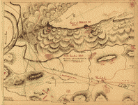
Pen and ink sketch map showing "route of regiment" of the "38th Brigade, Gilbert's Division, of Buel's [sic] Army" from Louisville to "Mitchelsville" (i.e., Mitchellville), Tennessee.
-
Description derived from published bibliography.
-
Available also through the Library of Congress web site as raster image.
-
1 map, col. ms, 53 x 43 cm.
- Creator
- Blakeslee, G. H.
- Created Published
-
[1862]
- Subject Headings
-
-
Kentucky--History--Civil War, 1861-1865
-
-
Manuscript maps.
-
-
United States--Kentucky.
- Notes
-
-
Scale ca. 1:1,020,000.
-
-
LC Civil War Maps (2nd ed.), 215.5
-
-
Pen and ink sketch map showing "route of regiment" of the "38th Brigade, Gilbert's Division, of Buel's [sic] Army" from Louisville to "Mitchelsville" (i.e., Mitchellville), Tennessee.
-
-
Description derived from published bibliography.
-
-
Available also through the Library of Congress web site as raster image.
- Medium
-
1 map, col. ms, 53 x 43 cm.
- Call Number
-
G3951.S5 1862 .B6
- Repository
-
Library of Congress Geography and Map Division Washington, D.C. 20540-4650 dcu
- Digital Id
-
g3951s cw0215500 http://hdl.loc.gov/loc.gmd/g3951s.cw0215500
- Library of Congress Catalog Number
- 99446408
Rights & Access
The maps in the Map Collections materials were either published prior to 1922, produced by the United States government, or both (see catalogue records that accompany each map for information regarding date of publication and source). The Library of Congress is providing access to these materials for educational and research purposes and is not aware of any U.S. copyright protection (see Title 17 of the United States Code) or any other restrictions in the Map Collection materials.
Note that the written permission of the copyright owners and/or other rights holders (such as publicity and/or privacy rights) is required for distribution, reproduction, or other use of protected items beyond that allowed by fair use or other statutory exemptions. Responsibility for making an independent legal assessment of an item and securing any necessary permissions ultimately rests with persons desiring to use the item.
More about Copyright and other Restrictions
For guidance about compiling full citations consult Citing Primary Sources.
Part of...
-
Civil War Maps
[2281]
-
Military Battles And Campaigns Cartographic Items
[3867]
-
Geography And Maps Division
[60803]
-
American Memory
[1121009]
More maps like this
-
 [Map of the environs of Pine Mountain, Lost Mountain, Kenesaw Mountain, and Little Kenesaw Mountain]
Contributor:
Blakeslee, G. H.
Site:
American Memory-cultural, Main Catalog
Original Format:
Map
Date:
1864
View catalog record
[Map of the environs of Pine Mountain, Lost Mountain, Kenesaw Mountain, and Little Kenesaw Mountain]
Contributor:
Blakeslee, G. H.
Site:
American Memory-cultural, Main Catalog
Original Format:
Map
Date:
1864
View catalog record
-
 May 17 to 23, 1864, Adairsville to Euharlee, GA, route of Harrison's brigade /
Contributor:
Blakeslee, G. H.
Site:
American Memory-cultural, Main Catalog
Original Format:
Map
Date:
1864
View catalog record
May 17 to 23, 1864, Adairsville to Euharlee, GA, route of Harrison's brigade /
Contributor:
Blakeslee, G. H.
Site:
American Memory-cultural, Main Catalog
Original Format:
Map
Date:
1864
View catalog record
-
 Atlanta campaign-1864. "Rossville" to "Snake Creek Gap."
Contributor:
Blakeslee, G. H.
Site:
American Memory-cultural, Main Catalog
Original Format:
Map
Date:
1864
View catalog record
Atlanta campaign-1864. "Rossville" to "Snake Creek Gap."
Contributor:
Blakeslee, G. H.
Site:
American Memory-cultural, Main Catalog
Original Format:
Map
Date:
1864
View catalog record
-
 Middle Tennessee /
Contributor:
Blakeslee, G. H.
Site:
American Memory-cultural, Main Catalog
Original Format:
Map
Date:
1863
View catalog record
Middle Tennessee /
Contributor:
Blakeslee, G. H.
Site:
American Memory-cultural, Main Catalog
Original Format:
Map
Date:
1863
View catalog record
-
 From the Etowah to Burnt-Hickory, Ga.
Contributor:
Blakeslee, G. H.
Site:
American Memory-cultural, Main Catalog
Original Format:
Map
Date:
1864
View catalog record
From the Etowah to Burnt-Hickory, Ga.
Contributor:
Blakeslee, G. H.
Site:
American Memory-cultural, Main Catalog
Original Format:
Map
Date:
1864
View catalog record
-
 From Mitchelsville [sic] to Gallatin--Sumner Co., Tenn., 1862 /
Contributor:
Blakeslee, G. H.
Site:
American Memory-cultural, Main Catalog
Original Format:
Map
Date:
1862
View catalog record
From Mitchelsville [sic] to Gallatin--Sumner Co., Tenn., 1862 /
Contributor:
Blakeslee, G. H.
Site:
American Memory-cultural, Main Catalog
Original Format:
Map
Date:
1862
View catalog record
-
 Nashville--Tenn. and vicinity 1863 /
Contributor:
Blakeslee, G. H.
Site:
American Memory-cultural, Main Catalog
Original Format:
Map
Date:
1863
View catalog record
Nashville--Tenn. and vicinity 1863 /
Contributor:
Blakeslee, G. H.
Site:
American Memory-cultural, Main Catalog
Original Format:
Map
Date:
1863
View catalog record
-
 Franklin--Tenn. profield [sic] June 1863 /
Contributor:
Blakeslee, G. H.
Site:
American Memory-cultural, Main Catalog
Original Format:
Map
Date:
1863
View catalog record
Franklin--Tenn. profield [sic] June 1863 /
Contributor:
Blakeslee, G. H.
Site:
American Memory-cultural, Main Catalog
Original Format:
Map
Date:
1863
View catalog record
-
 Chattanooga Tenn. 1863 /
Contributor:
Blakeslee, G. H.
Site:
American Memory-cultural, Main Catalog
Original Format:
Map
Date:
1863
View catalog record
Chattanooga Tenn. 1863 /
Contributor:
Blakeslee, G. H.
Site:
American Memory-cultural, Main Catalog
Original Format:
Map
Date:
1863
View catalog record
-
 Winter quarters 1864 : [vicinity of Lookout Mountain, Tennessee] /
Contributor:
Blakeslee, G. H.
Site:
American Memory-cultural, Main Catalog
Original Format:
Map
Date:
1864
View catalog record
Winter quarters 1864 : [vicinity of Lookout Mountain, Tennessee] /
Contributor:
Blakeslee, G. H.
Site:
American Memory-cultural, Main Catalog
Original Format:
Map
Date:
1864
View catalog record
-
 Lloyd's official map of the State of Kentucky : compiled from actual surveys and official documents, showing every rail road & rail road station with ...
Contributor:
Lloyd, James T.
Site:
American Memory-cultural, Main Catalog
Original Format:
Map
Date:
1862
View catalog record
Lloyd's official map of the State of Kentucky : compiled from actual surveys and official documents, showing every rail road & rail road station with ...
Contributor:
Lloyd, James T.
Site:
American Memory-cultural, Main Catalog
Original Format:
Map
Date:
1862
View catalog record
-
 Map of the cost [sic] of Georgia & Florida.
Site:
American Memory-cultural, Main Catalog
Original Format:
Map
Date:
1863
View catalog record
Map of the cost [sic] of Georgia & Florida.
Site:
American Memory-cultural, Main Catalog
Original Format:
Map
Date:
1863
View catalog record
-
 Military map of the States of Kentucky and Tennessee, within eleven miles of the 35th parallel of latitude or southern boundary of Tennessee; compiled from ...
Contributor:
Swann, Charles E.
Site:
American Memory-cultural, Main Catalog
Original Format:
Map
Date:
1863
View catalog record
Military map of the States of Kentucky and Tennessee, within eleven miles of the 35th parallel of latitude or southern boundary of Tennessee; compiled from ...
Contributor:
Swann, Charles E.
Site:
American Memory-cultural, Main Catalog
Original Format:
Map
Date:
1863
View catalog record
-
 Map of Kentucky and Tennessee.
Site:
American Memory-cultural, Main Catalog
Original Format:
Map
Date:
1864
View catalog record
Map of Kentucky and Tennessee.
Site:
American Memory-cultural, Main Catalog
Original Format:
Map
Date:
1864
View catalog record
-
 Military map of the States of Kentucky and Tennessee, within eleven miles of the 35th parallel of latitude or southern boundary of Tennessee; compiled from ...
Contributor:
Swann, Charles E.
Site:
American Memory-cultural, Main Catalog
Original Format:
Map
Date:
1865
View catalog record
Military map of the States of Kentucky and Tennessee, within eleven miles of the 35th parallel of latitude or southern boundary of Tennessee; compiled from ...
Contributor:
Swann, Charles E.
Site:
American Memory-cultural, Main Catalog
Original Format:
Map
Date:
1865
View catalog record
-
 Map of the rebel fortifications at Columbus, Ky. /
Contributor:
Cullum, George W.
Site:
American Memory-cultural, Main Catalog
Original Format:
Map
Date:
1862
View catalog record
Map of the rebel fortifications at Columbus, Ky. /
Contributor:
Cullum, George W.
Site:
American Memory-cultural, Main Catalog
Original Format:
Map
Date:
1862
View catalog record
You might also like
-

 The Union cause in Kentucky, 1860-1865,
Contributor:
Speed, Thos
Site:
Main Catalog
Original Format:
Book
Date:
1907
The Union cause in Kentucky, 1860-1865,
Contributor:
Speed, Thos
Site:
Main Catalog
Original Format:
Book
Date:
1907
-
Drafts in Kentucky during civil war.
Contributor:
United States. Adjutant-general's office
Site:
Main Catalog
Original Format:
Book
Date:
1909
-
Millicent Halford. A tale of the dark days of Kentucky in the year 1861.
Contributor:
Remick, Martha
Site:
Main Catalog
Original Format:
Book
Date:
1865
-
"Morgan's men" a narrative of personal experiences /
Contributor:
Stone, Henry Lane
Site:
American Memory-cultural
Original Format:
Book
Date:
1919
-
Reminiscences of a soldier of the Orphan brigade
Contributor:
Young, Lot D.
Site:
American Memory-cultural
Original Format:
Book
Date:
1918
-
The peaceable Americans of 1860-1861; a study in public opinion,
Contributor:
Scrugham, Mary
Site:
Main Catalog
Original Format:
Book
Date:
1921