Map
Plan of the Battle of Fredericksburg, Virginia.

| Format |
Map |
|---|---|
| Contributors |
Sneden, Robert Knox |
| Dates |
1861 |
| Location |
Fredericksburg Region United States Virginia |
| Language |
English |
| Subjects |
Battle Of Fredericksburg Fredericksburg Region United States Va Virginia |
- Title
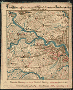
- Plan of the Battle of Fredericksburg, Virginia.
- Description
-
Color coding indicates the location of Union and Confederate forces.
-
NOTE: Researchers will be served a color photocopy of this diary image.
-
Relief shown by hachures.
-
This item is from the collections of the Virginia Historical Society; please contact the institution for more information.
-
Map shows the area between the Rappahannock and Massaponax rivers including Fredericksburg and Marie's Heights. The location of Confederate troops under Longstreet and Jackson and Union troops under Burnside are indicated. Due to Burnside's slow maneuvering, the Confederates were able to use the topography to their advantage, in particular the bluffs overlooking the town and river. After sustaining heavy losses crossing the Rappahannock River, Burnside decided against renewed attacks and withdrew from Fredericksburg on the 15th of December 1862.
-
Available also through the Library of Congress web site as a raster image.
-
In the Robert Knox Sneden Diary (Mss5:1 Sn237:1 v. 4, p. 106).
-
Manuscripts
-
1 map : pen-and-ink and watercolor ; 16 x 22 cm.
- Creator
- Sneden, Robert Knox, 1832-1918.
- Created Published
-
[1862-1865].
- Subject Headings
-
-
Fredericksburg, Battle of, Fredericksburg, Va., 1862
-
-
United States--Virginia--Fredericksburg Region.
-
-
Fredericksburg, Battle of, Fredericksburg, Va.
- Notes
-
-
Color coding indicates the location of Union and Confederate forces.
-
-
NOTE: Researchers will be served a color photocopy of this diary image.
-
-
Relief shown by hachures.
-
-
This item is from the collections of the Virginia Historical Society; please contact the institution for more information.
-
-
Map shows the area between the Rappahannock and Massaponax rivers including Fredericksburg and Marie's Heights. The location of Confederate troops under Longstreet and Jackson and Union troops under Burnside are indicated. Due to Burnside's slow maneuvering, the Confederates were able to use the topography to their advantage, in particular the bluffs overlooking the town and river. After sustaining heavy losses crossing the Rappahannock River, Burnside decided against renewed attacks and withdrew from Fredericksburg on the 15th of December 1862.
-
-
Available also through the Library of Congress web site as a raster image.
-
-
In the Robert Knox Sneden Diary (Mss5:1 Sn237:1 v. 4, p. 106).
-
-
Manuscripts
- Medium
-
1 map : pen-and-ink and watercolor ; 16 x 22 cm.
- Repository
-
Virginia Historical Society, P.O. Box 7311, Richmond, VA 23221-0311 USA vau
- Digital Id
-
gvhs01 vhs00124 http://hdl.loc.gov/loc.ndlpcoop/gvhs01.vhs00124
Rights & Access
The maps in the Map Collections materials were either published prior to 1922, produced by the United States government, or both (see catalogue records that accompany each map for information regarding date of publication and source). The Library of Congress is providing access to these materials for educational and research purposes and is not aware of any U.S. copyright protection (see Title 17 of the United States Code) or any other restrictions in the Map Collection materials.
Note that the written permission of the copyright owners and/or other rights holders (such as publicity and/or privacy rights) is required for distribution, reproduction, or other use of protected items beyond that allowed by fair use or other statutory exemptions. Responsibility for making an independent legal assessment of an item and securing any necessary permissions ultimately rests with persons desiring to use the item.
More about Copyright and other Restrictions
For guidance about compiling full citations consult Citing Primary Sources.
Part of...
-
Civil War Maps
[2281]
-
Military Battles And Campaigns Cartographic Items
[3867]
-
Geography And Maps Division
[60803]
-
American Memory
[1121009]
More maps like this
-
 Plan of the Battle of Fredericksburg, Va., Decr. 13, 1862.
Contributor:
Sneden, Robert Knox
Site:
American Memory-cultural
Original Format:
Map
Date:
1861
Plan of the Battle of Fredericksburg, Va., Decr. 13, 1862.
Contributor:
Sneden, Robert Knox
Site:
American Memory-cultural
Original Format:
Map
Date:
1861
-
 Position of Union and Rebel armies at Fredericksburg, Decr. 1st 1862
Contributor:
Sneden, Robert Knox
Site:
American Memory-cultural
Original Format:
Map
Date:
1861
Position of Union and Rebel armies at Fredericksburg, Decr. 1st 1862
Contributor:
Sneden, Robert Knox
Site:
American Memory-cultural
Original Format:
Map
Date:
1861
-
 The Rebel entrenched position at Fredericksburg, Va. showing Hooker's flank march on Chancellorsville 3rd and 4th May 1863.
Contributor:
Sneden, Robert Knox
Site:
American Memory-cultural
Original Format:
Map
Date:
1863
The Rebel entrenched position at Fredericksburg, Va. showing Hooker's flank march on Chancellorsville 3rd and 4th May 1863.
Contributor:
Sneden, Robert Knox
Site:
American Memory-cultural
Original Format:
Map
Date:
1863
-
 Plan of attack on Marie's Heights, Fredericksburg Va. By Maj. Genl. John Sedgwick, USA, with the 6th Army Corps. Sunday May 3rd 1863.
Contributor:
Sneden, Robert Knox
Site:
American Memory-cultural
Original Format:
Map
Date:
1863
Plan of attack on Marie's Heights, Fredericksburg Va. By Maj. Genl. John Sedgwick, USA, with the 6th Army Corps. Sunday May 3rd 1863.
Contributor:
Sneden, Robert Knox
Site:
American Memory-cultural
Original Format:
Map
Date:
1863
-
 Plan of the battle of Fredericksburg, Virginia : shewing [sic] Union and Rebel positions 13th Decr 1862.
Contributor:
Sneden, Robert Knox
Site:
American Memory-cultural
Original Format:
Map
Date:
1862
Plan of the battle of Fredericksburg, Virginia : shewing [sic] Union and Rebel positions 13th Decr 1862.
Contributor:
Sneden, Robert Knox
Site:
American Memory-cultural
Original Format:
Map
Date:
1862
-
 Plan of the battle of Fredericksburg, Virginia : fought Decr. 13th 1862.
Contributor:
Sneden, Robert Knox
Site:
American Memory-cultural
Original Format:
Map
Date:
1861
Plan of the battle of Fredericksburg, Virginia : fought Decr. 13th 1862.
Contributor:
Sneden, Robert Knox
Site:
American Memory-cultural
Original Format:
Map
Date:
1861
-
 The Mud march ... shewing [sic] movement on Bank's Ford Jany. 19th 1863 by Hooker, Franklin & Sumner.
Contributor:
Sneden, Robert Knox
Site:
American Memory-cultural
Original Format:
Map
Date:
1861
The Mud march ... shewing [sic] movement on Bank's Ford Jany. 19th 1863 by Hooker, Franklin & Sumner.
Contributor:
Sneden, Robert Knox
Site:
American Memory-cultural
Original Format:
Map
Date:
1861
-
 The field of Fredericksburg : showing the positions of the troops on the morning of December 13, 1862 /
Contributor:
Geo. W. Stadly & Co
Site:
American Memory-cultural
Original Format:
Map
Date:
1898-01-01
The field of Fredericksburg : showing the positions of the troops on the morning of December 13, 1862 /
Contributor:
Geo. W. Stadly & Co
Site:
American Memory-cultural
Original Format:
Map
Date:
1898-01-01
-
 Map of the battle field of Fredericksburg, Dec. 13, 1862 /
Contributor:
Blackford, B. L.
Site:
American Memory-cultural
Original Format:
Map
Date:
1866
Map of the battle field of Fredericksburg, Dec. 13, 1862 /
Contributor:
Blackford, B. L.
Site:
American Memory-cultural
Original Format:
Map
Date:
1866
-
 Battle-field & environs of the city of Fredericksburg.
Site:
American Memory-cultural
Original Format:
Map
Date:
1863
Battle-field & environs of the city of Fredericksburg.
Site:
American Memory-cultural
Original Format:
Map
Date:
1863
-
 Plan of the Battle of Fredericksburg.
Contributor:
Sneden, Robert Knox
Site:
American Memory-cultural
Original Format:
Map
Date:
1862
Plan of the Battle of Fredericksburg.
Contributor:
Sneden, Robert Knox
Site:
American Memory-cultural
Original Format:
Map
Date:
1862
-
 The line of the Rappahannock, 30th April 1863 Showing position of Union and Rebel armies at and near Fredericksburg, Va.
Contributor:
Sneden, Robert Knox
Site:
American Memory-cultural
Original Format:
Map
Date:
1862
The line of the Rappahannock, 30th April 1863 Showing position of Union and Rebel armies at and near Fredericksburg, Va.
Contributor:
Sneden, Robert Knox
Site:
American Memory-cultural
Original Format:
Map
Date:
1862
-
 Plan of the battle of Fredericksburg. Fought 13th Decr. 1862.
Contributor:
Sneden, Robert Knox
Site:
American Memory-cultural
Original Format:
Map
Date:
1862
Plan of the battle of Fredericksburg. Fought 13th Decr. 1862.
Contributor:
Sneden, Robert Knox
Site:
American Memory-cultural
Original Format:
Map
Date:
1862
-
 Passages of the Rappahannock and Battle of Fredericksburg, December 10th to 16th, 1862 : copied from the original belonging to Gen'l. Burnside /
Contributor:
Callahan, Denis
Site:
American Memory-cultural
Original Format:
Map
Date:
1863
Passages of the Rappahannock and Battle of Fredericksburg, December 10th to 16th, 1862 : copied from the original belonging to Gen'l. Burnside /
Contributor:
Callahan, Denis
Site:
American Memory-cultural
Original Format:
Map
Date:
1863
-
 Sketch of Banks Ford.
Site:
American Memory-cultural, Main Catalog
Original Format:
Map
Date:
1863
View catalog record
Sketch of Banks Ford.
Site:
American Memory-cultural, Main Catalog
Original Format:
Map
Date:
1863
View catalog record
-
 Map of the battle of Chancellorsville, including operations from April 29th to May 5th, 1863.
Contributor:
Sneden, Robert Knox
Site:
American Memory-cultural
Original Format:
Map
Date:
1861
Map of the battle of Chancellorsville, including operations from April 29th to May 5th, 1863.
Contributor:
Sneden, Robert Knox
Site:
American Memory-cultural
Original Format:
Map
Date:
1861
You might also like
-
 Basil Gordon Brick House, Fredericksburg, Virginia
Contributor:
Johnston, Frances Benjamin
Site:
Prints & Photographs
Original Format:
Photo, Print, Drawing
Date:
1927
Basil Gordon Brick House, Fredericksburg, Virginia
Contributor:
Johnston, Frances Benjamin
Site:
Prints & Photographs
Original Format:
Photo, Print, Drawing
Date:
1927
-
 Fortifications. Fredericksburg, Va.?
Site:
Prints & Photographs, Main Catalog
Original Format:
Photo, Print, Drawing
Date:
1861
View catalog record
Fortifications. Fredericksburg, Va.?
Site:
Prints & Photographs, Main Catalog
Original Format:
Photo, Print, Drawing
Date:
1861
View catalog record
-
 Burying the dead at hospital in Fredericksburg, Va.
Site:
Prints & Photographs
Original Format:
Photo, Print, Drawing
Date:
1861
Burying the dead at hospital in Fredericksburg, Va.
Site:
Prints & Photographs
Original Format:
Photo, Print, Drawing
Date:
1861
-
 Burying the dead at hospital in Fredericksburg, Va.
Site:
Prints & Photographs, Main Catalog
Original Format:
Photo, Print, Drawing
Date:
1864
View catalog record
Burying the dead at hospital in Fredericksburg, Va.
Site:
Prints & Photographs, Main Catalog
Original Format:
Photo, Print, Drawing
Date:
1864
View catalog record
-
 To the freeholders of the Counties of Gloucester, Middlesex, Essex. King and Queen, King William Caroline, Westmoreland, Richmond, Northumberland, and Lancaster. Woodbury, in Richmond County. ...
Contributor:
Lee, Arthur
Site:
American Memory-cultural
Original Format:
Book
Date:
1788
To the freeholders of the Counties of Gloucester, Middlesex, Essex. King and Queen, King William Caroline, Westmoreland, Richmond, Northumberland, and Lancaster. Woodbury, in Richmond County. ...
Contributor:
Lee, Arthur
Site:
American Memory-cultural
Original Format:
Book
Date:
1788
-
 A plan, for the establishment of iron-works in Spotsylvania county, and state of Virginia .... [1805].
Site:
American Memory-cultural
Original Format:
Book
Date:
1805
A plan, for the establishment of iron-works in Spotsylvania county, and state of Virginia .... [1805].
Site:
American Memory-cultural
Original Format:
Book
Date:
1805