Map
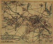
Battle-field & environs of the city of Fredericksburg.

| Format |
Map |
|---|---|
| Dates |
1863 |
| Location |
Fredericksburg Fredericksburg Region United States Virginia |
| Language |
English |
| Subjects |
Battle Of Civil War Fredericksburg Fredericksburg Region Fredericksburg Region (Va.) History United States Va Virginia |
- Title
- Battle-field & environs of the city of Fredericksburg.
- Description
-
"To James G. McCabe, Jr., from his friend James W.B."
-
Dated 1863 in pencil in upper right corner.
-
Dated on map: 13th Dec. 1862.
-
Relief shown by hachures.
-
Signed in lower right corner: J.M.B.
-
This item is in the Map Collection of the Library of Virginia; please contact the Library's Archives Research Services department for more information.
-
Swem, C.E. Maps relating to Virginia, 1008
-
Available also through the Library of Congress web site as raster image.
-
April 2002, Map Cataloging Team.
-
Civil War Map Proj. no.: LVA00050.
-
Conservation: Etherington Conservation Center, April 2002.
-
Digital image available: 5 15/16 x 9 3/8 in.
-
Map accession no. 5188x.
-
Previously filed as: 755.36 M6 1861-1865 1863.
-
1 map : ms., col. mounted on paper ; 15 x 24 cm on sheet x 18 27 cm.
- Created Published
-
[1863?]
- Subject Headings
-
-
Fredericksburg Region (Va.)--History--Civil War, 1861-1865
-
-
Fredericksburg, Battle of, Fredericksburg, Va., 1862
-
-
United States--Virginia--Fredericksburg Region.
- Notes
-
-
"To James G. McCabe, Jr., from his friend James W.B."
-
-
Dated 1863 in pencil in upper right corner.
-
-
Dated on map: 13th Dec. 1862.
-
-
Relief shown by hachures.
-
-
Signed in lower right corner: J.M.B.
-
-
This item is in the Map Collection of the Library of Virginia; please contact the Library's Archives Research Services department for more information.
-
-
Swem, C.E. Maps relating to Virginia, 1008
-
-
Available also through the Library of Congress web site as raster image.
-
-
April 2002, Map Cataloging Team.
-
-
Civil War Map Proj. no.: LVA00050.
-
-
Conservation: Etherington Conservation Center, April 2002.
-
-
Digital image available: 5 15/16 x 9 3/8 in.
-
-
Map accession no. 5188x.
-
-
Previously filed as: 755.36 M6 1861-1865 1863.
- Medium
-
1 map : ms., col. mounted on paper ; 15 x 24 cm on sheet x 18 27 cm.
- Repository
-
Library of Virginia Richmond, VA 23219-8000 USA vau For copies contact: Archives Research Services.
- Digital Id
-
glva01 lva00050 http://hdl.loc.gov/loc.ndlpcoop/glva01.lva00050
Rights & Access
The maps in the Map Collections materials were either published prior to 1922, produced by the United States government, or both (see catalogue records that accompany each map for information regarding date of publication and source). The Library of Congress is providing access to these materials for educational and research purposes and is not aware of any U.S. copyright protection (see Title 17 of the United States Code) or any other restrictions in the Map Collection materials.
Note that the written permission of the copyright owners and/or other rights holders (such as publicity and/or privacy rights) is required for distribution, reproduction, or other use of protected items beyond that allowed by fair use or other statutory exemptions. Responsibility for making an independent legal assessment of an item and securing any necessary permissions ultimately rests with persons desiring to use the item.
More about Copyright and other Restrictions
For guidance about compiling full citations consult Citing Primary Sources.
Part of...
-
Civil War Maps
[2281]
-
Military Battles And Campaigns Cartographic Items
[3867]
-
Geography And Maps Division
[60803]
-
American Memory
[1121009]
More maps like this
-
 The field of Fredericksburg : showing the positions of the troops on the morning of December 13, 1862 /
Contributor:
Geo. W. Stadly & Co
Site:
American Memory-cultural
Original Format:
Map
Date:
1898-01-01
The field of Fredericksburg : showing the positions of the troops on the morning of December 13, 1862 /
Contributor:
Geo. W. Stadly & Co
Site:
American Memory-cultural
Original Format:
Map
Date:
1898-01-01
-
 Map of the battle field of Fredericksburg, Dec. 13, 1862 /
Contributor:
Blackford, B. L.
Site:
American Memory-cultural
Original Format:
Map
Date:
1866
Map of the battle field of Fredericksburg, Dec. 13, 1862 /
Contributor:
Blackford, B. L.
Site:
American Memory-cultural
Original Format:
Map
Date:
1866
-
 Passages of the Rappahannock and Battle of Fredericksburg, December 10th to 16th, 1862 : copied from the original belonging to Gen'l. Burnside /
Contributor:
Callahan, Denis
Site:
American Memory-cultural
Original Format:
Map
Date:
1863
Passages of the Rappahannock and Battle of Fredericksburg, December 10th to 16th, 1862 : copied from the original belonging to Gen'l. Burnside /
Contributor:
Callahan, Denis
Site:
American Memory-cultural
Original Format:
Map
Date:
1863
-
 Sketch of Banks Ford.
Site:
American Memory-cultural, Main Catalog
Original Format:
Map
Date:
1863
View catalog record
Sketch of Banks Ford.
Site:
American Memory-cultural, Main Catalog
Original Format:
Map
Date:
1863
View catalog record
-
 Plan of the Battle of Fredericksburg, Va., Decr. 13, 1862.
Contributor:
Sneden, Robert Knox
Site:
American Memory-cultural
Original Format:
Map
Date:
1861
Plan of the Battle of Fredericksburg, Va., Decr. 13, 1862.
Contributor:
Sneden, Robert Knox
Site:
American Memory-cultural
Original Format:
Map
Date:
1861
-
 Position of Union and Rebel armies at Fredericksburg, Decr. 1st 1862
Contributor:
Sneden, Robert Knox
Site:
American Memory-cultural
Original Format:
Map
Date:
1861
Position of Union and Rebel armies at Fredericksburg, Decr. 1st 1862
Contributor:
Sneden, Robert Knox
Site:
American Memory-cultural
Original Format:
Map
Date:
1861
-
 Fredericksburg /
Contributor:
United States. National Park Service
Site:
American Memory-cultural, Main Catalog
Original Format:
Map
Date:
1979
View catalog record
Fredericksburg /
Contributor:
United States. National Park Service
Site:
American Memory-cultural, Main Catalog
Original Format:
Map
Date:
1979
View catalog record
-
 Plan of attack on Marie's Heights, Fredericksburg Va. By Maj. Genl. John Sedgwick, USA, with the 6th Army Corps. Sunday May 3rd 1863.
Contributor:
Sneden, Robert Knox
Site:
American Memory-cultural
Original Format:
Map
Date:
1863
Plan of attack on Marie's Heights, Fredericksburg Va. By Maj. Genl. John Sedgwick, USA, with the 6th Army Corps. Sunday May 3rd 1863.
Contributor:
Sneden, Robert Knox
Site:
American Memory-cultural
Original Format:
Map
Date:
1863
-
 The Rebel entrenched position at Fredericksburg, Va. showing Hooker's flank march on Chancellorsville 3rd and 4th May 1863.
Contributor:
Sneden, Robert Knox
Site:
American Memory-cultural
Original Format:
Map
Date:
1863
The Rebel entrenched position at Fredericksburg, Va. showing Hooker's flank march on Chancellorsville 3rd and 4th May 1863.
Contributor:
Sneden, Robert Knox
Site:
American Memory-cultural
Original Format:
Map
Date:
1863
-
 [Map of the Rappahannock River below Fredericksburg, showing Port Royal, Moss Neck, Corbin's Neck, etc.].
Site:
American Memory-cultural, Main Catalog
Original Format:
Map
Date:
1862
View catalog record
[Map of the Rappahannock River below Fredericksburg, showing Port Royal, Moss Neck, Corbin's Neck, etc.].
Site:
American Memory-cultural, Main Catalog
Original Format:
Map
Date:
1862
View catalog record
-
 Approaches of A. of P. to Fredericksburg.
Contributor:
United States. Army of the Potomac
Site:
American Memory-cultural, Main Catalog
Original Format:
Map
Date:
1862
View catalog record
Approaches of A. of P. to Fredericksburg.
Contributor:
United States. Army of the Potomac
Site:
American Memory-cultural, Main Catalog
Original Format:
Map
Date:
1862
View catalog record
-
 [Map of portion of Fredericksburg, Spotsylvania County, Virginia] /
Contributor:
Smith, Normand
Site:
American Memory-cultural
Original Format:
Map
[Map of portion of Fredericksburg, Spotsylvania County, Virginia] /
Contributor:
Smith, Normand
Site:
American Memory-cultural
Original Format:
Map
-
 [Map of the Fredericksburg and Chancellorsville battlefields, 1862-1863].
Contributor:
Hotchkiss, Jedediah
Site:
American Memory-cultural, Main Catalog
Original Format:
Map
Date:
1862
View catalog record
[Map of the Fredericksburg and Chancellorsville battlefields, 1862-1863].
Contributor:
Hotchkiss, Jedediah
Site:
American Memory-cultural, Main Catalog
Original Format:
Map
Date:
1862
View catalog record
-
 Map of the Rappahannock River fron [sic] Port Royal to Richards Ferry /
Contributor:
Vernam, John S.
Site:
American Memory-cultural, Main Catalog
Original Format:
Map
Date:
1863
View catalog record
Map of the Rappahannock River fron [sic] Port Royal to Richards Ferry /
Contributor:
Vernam, John S.
Site:
American Memory-cultural, Main Catalog
Original Format:
Map
Date:
1863
View catalog record
-
 Map of a portion of the Rappahannock River and vicinity, Virginia : to illustrate the operations of the Army of Northern Virginia C.S. and the ...
Contributor:
Hotchkiss, Jedediah
Site:
American Memory-cultural, Main Catalog
Original Format:
Map
Date:
1866
View catalog record
Map of a portion of the Rappahannock River and vicinity, Virginia : to illustrate the operations of the Army of Northern Virginia C.S. and the ...
Contributor:
Hotchkiss, Jedediah
Site:
American Memory-cultural, Main Catalog
Original Format:
Map
Date:
1866
View catalog record
-
 Map [of] central Virginia showing the movements of the Tenth New York Cavalry in the campaigs [sic] of 1864.
Contributor:
Preston, Noble D.
Site:
American Memory-cultural, Main Catalog
Original Format:
Map
Date:
1892
View catalog record
Map [of] central Virginia showing the movements of the Tenth New York Cavalry in the campaigs [sic] of 1864.
Contributor:
Preston, Noble D.
Site:
American Memory-cultural, Main Catalog
Original Format:
Map
Date:
1892
View catalog record
You might also like
-
 Fortifications. Fredericksburg, Va.?
Site:
Prints & Photographs, Main Catalog
Original Format:
Photo, Print, Drawing
Date:
1861
View catalog record
Fortifications. Fredericksburg, Va.?
Site:
Prints & Photographs, Main Catalog
Original Format:
Photo, Print, Drawing
Date:
1861
View catalog record
-
 Burying the dead at hospital in Fredericksburg, Va.
Site:
Prints & Photographs
Original Format:
Photo, Print, Drawing
Date:
1861
Burying the dead at hospital in Fredericksburg, Va.
Site:
Prints & Photographs
Original Format:
Photo, Print, Drawing
Date:
1861
-
 Burying the dead at hospital in Fredericksburg, Va.
Site:
Prints & Photographs, Main Catalog
Original Format:
Photo, Print, Drawing
Date:
1864
View catalog record
Burying the dead at hospital in Fredericksburg, Va.
Site:
Prints & Photographs, Main Catalog
Original Format:
Photo, Print, Drawing
Date:
1864
View catalog record
-
 Rear view of Fredericksburg, Va. Confederate fortifications in foreground
Site:
Prints & Photographs, Main Catalog
Original Format:
Photo, Print, Drawing
Date:
1861
View catalog record
Rear view of Fredericksburg, Va. Confederate fortifications in foreground
Site:
Prints & Photographs, Main Catalog
Original Format:
Photo, Print, Drawing
Date:
1861
View catalog record
-
 Fredericksburg
Contributor:
Waud, Alfred R. (Alfred Rudolph), Waud, Alfred R.
Site:
Prints & Photographs, Main Catalog
Original Format:
Photo, Print, Drawing
Date:
1862
View catalog record
Fredericksburg
Contributor:
Waud, Alfred R. (Alfred Rudolph), Waud, Alfred R.
Site:
Prints & Photographs, Main Catalog
Original Format:
Photo, Print, Drawing
Date:
1862
View catalog record
-
 Bringing the wounded into Fredericksburg in the afternoon--of Saturday
Contributor:
Lumley, Arthur
Site:
Prints & Photographs, Main Catalog
Original Format:
Photo, Print, Drawing
Date:
1862
View catalog record
Bringing the wounded into Fredericksburg in the afternoon--of Saturday
Contributor:
Lumley, Arthur
Site:
Prints & Photographs, Main Catalog
Original Format:
Photo, Print, Drawing
Date:
1862
View catalog record